

View Information About HSR Ratings
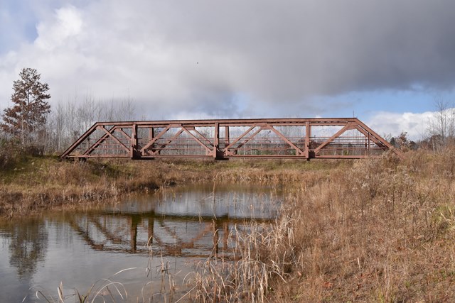
Relocated and reused for pedestrians in a recreation area, this is one of the few preserved truss bridges in northern lower Michigan. Prior to relocation, this bridge was unaltered, and had excellent historic integrity, despite deterioration of the floorbeams and lower chord connections. When the bridge was moved the trusses were narrowed, probably to reduce deck, new floorbeam, and abutment costs. The bridge was painted, but the lower chord section loss was not repaired prior to painting. However one remarkable change was made, and it is not known if it was on purpose or not: they put the trusses up backwards! You read that right, the trusses are BACKWARDS! This is one of the most unusual alterations ever encountered on a truss bridge! Another unfortunate outcome is that the beautiful riveted and original lattice railings were removed from the bridge. Perhaps if someone had left the attractive lattice railings in place on the bridge, then the contractor who erected the bridge would have figured out which way the trusses go! The reversal of the trusses may be the result of a contractor unfamiliar with the history of this very special bridge misinterpreting the design of this bridge. This bridge was one of the early Michigan State Highway Department standard plans for truss bridges. The design is detailed in historical literature linked to on this page. The unique design included interior knee bracing on the vertical members... in other words, the opposite of most pony truss bridges. Most pony truss bridges had outriggers, which was bracing that extended outside the truss lines. C. V. Dewart, who worked for the highway department felt that interior knee braces functioned better for lateral stability than outriggers, so he designed a bridge with interior knee bracing, which this bridge is an example of. It is possible that whoever reassembled this bridge thought the interior knee braces were outriggers.
![]()
![]()
![]()
Coordinates (Latitude, Longitude):
Search For Additional Bridge Listings:
Bridgehunter.com: View listed bridges within 0.5 miles (0.8 kilometers) of this bridge.
Bridgehunter.com: View listed bridges within 10 miles (16 kilometers) of this bridge.
Additional Maps:
Google Streetview (If Available)
GeoHack (Additional Links and Coordinates)
Apple Maps (Via DuckDuckGo Search)
Apple Maps (Apple devices only)
Android: Open Location In Your Map or GPS App
Flickr Gallery (Find Nearby Photos)
Wikimedia Commons (Find Nearby Photos)
Directions Via Sygic For Android
Directions Via Sygic For iOS and Android Dolphin Browser
USGS National Map (United States Only)
Historical USGS Topo Maps (United States Only)
Historic Aerials (United States Only)
CalTopo Maps (United States Only)

© Copyright 2003-2026, HistoricBridges.org. All Rights Reserved. Disclaimer: HistoricBridges.org is a volunteer group of private citizens. HistoricBridges.org is NOT a government agency, does not represent or work with any governmental agencies, nor is it in any way associated with any government agency or any non-profit organization. While we strive for accuracy in our factual content, HistoricBridges.org offers no guarantee of accuracy. Information is provided "as is" without warranty of any kind, either expressed or implied. Information could include technical inaccuracies or errors of omission. Opinions and commentary are the opinions of the respective HistoricBridges.org member who made them and do not necessarily represent the views of anyone else, including any outside photographers whose images may appear on the page in which the commentary appears. HistoricBridges.org does not bear any responsibility for any consequences resulting from the use of this or any other HistoricBridges.org information. Owners and users of bridges have the responsibility of correctly following all applicable laws, rules, and regulations, regardless of any HistoricBridges.org information.
![]()