We Recommend:
Bach Steel - Experts at historic truss bridge restoration.
BridgeHunter.com Phase 1 is released to the public! - Visit Now
Paw Paw River Railroad Bridge

Primary Photographer(s): Nathan Holth
Bridge Documented: March 4, 2012 and April 8, 2012
Benton Harbor: Berrien County, Michigan: United States
Metal Deck Girder, Movable: Single Leaf Bascule (Fixed Trunnion) and Approach Spans: Metal Deck Girder, Fixed
1911 By Builder/Contractor: Wisconsin Bridge and Iron Company of Milwaukee, Wisconsin
Not Available or Not Applicable
71.0 Feet (21.6 Meters)
123.0 Feet (37.5 Meters)
Not Available
1 Main Span(s) and 2 Approach Span(s)
Not Applicable

View Information About HSR Ratings
Bridge Documentation
View Archived National Bridge Inventory Report - Has Additional Details and Evaluation
View A Historical Article About This Bridge
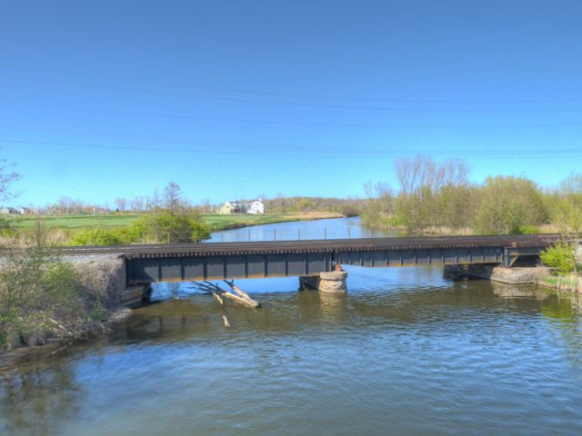
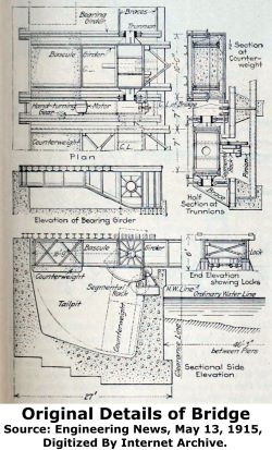
It might be hard to believe today, but the Paw Paw River here used to be navigable for boats and this railroad bridge was originally built as a bascule bridge. Today, the bridge no longer operates, and nearly all traces of its movable equipment, as well as the trunnion, and counterweight have been removed. However the original bascule leaf remains in place as a fixed deck plate girder. The giveaway that this was a bascule leaf is that the single span simple girder is not symmetrical, with the girder being less deep at the western end. The eastern end of the leaf, which originally had an extension where the trunnion was located has been cut off and removed. The eastern approach span, which passed over the counterweight and tail pit, and which also functioned as the trunnion girder, holding the trunnion in place, has also been removed and replaced. In short, everything in the superstructure from the trunnion to the counterweight, including the trunnion and the section of the girder that the trunnion passed through, has been removed and replaced. The western approach span is original, however. The substructure remains original as well. The tail pit itself remains. Typical of railroad bascule bridges it is a single leaf bascule.
This bridge was unusual as a small-scale railroad bascule bridge. The bridge carries two sets of tracks. It was built as two separate superstructures parallel to each other. It would have been possible to raise one side of the bridge and leave the other side lowered. This would have allowed workers to do repair work on one half of the bridge, while leaving the other half open to trains.
This bridge was originally built for the Pere Marquette Railroad, which became part of Chesapeake and Ohio, and is today CSX.
Because of its severe alteration, the bridge is not highly historically significant. However, it does have a well-documented history thanks to a historical article about the bridge, and it is an interesting reminder of the past in Benton Harbor and the Paw Paw River.
![]()
Photo Galleries and Videos: Paw Paw River Railroad Bridge
Bridge Photo-Documentation
Original / Full Size PhotosA collection of overview and detail photos. This gallery offers photos in the highest available resolution and file size in a touch-friendly popup viewer.
Alternatively, Browse Without Using Viewer
![]()
Bridge Photo-Documentation
Mobile Optimized PhotosA collection of overview and detail photos. This gallery features data-friendly, fast-loading photos in a touch-friendly popup viewer.
Alternatively, Browse Without Using Viewer
![]()
Maps and Links: Paw Paw River Railroad Bridge
Coordinates (Latitude, Longitude):
Search For Additional Bridge Listings:
Bridgehunter.com: View listed bridges within 0.5 miles (0.8 kilometers) of this bridge.
Bridgehunter.com: View listed bridges within 10 miles (16 kilometers) of this bridge.
Additional Maps:
Google Streetview (If Available)
GeoHack (Additional Links and Coordinates)
Apple Maps (Via DuckDuckGo Search)
Apple Maps (Apple devices only)
Android: Open Location In Your Map or GPS App
Flickr Gallery (Find Nearby Photos)
Wikimedia Commons (Find Nearby Photos)
Directions Via Sygic For Android
Directions Via Sygic For iOS and Android Dolphin Browser
USGS National Map (United States Only)
Historical USGS Topo Maps (United States Only)
Historic Aerials (United States Only)
CalTopo Maps (United States Only)


