

View Information About HSR Ratings
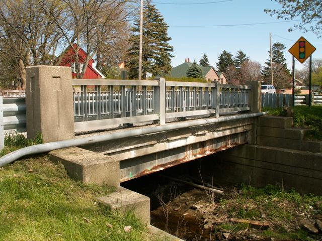
This bridge is not really all that noteworthy, but it serves as a great example for bridge researchers. From the top of the bridge it appears to be an unassuming 1940s/1950s steel stringer bridge, based on the railings. The simple elevation view reveals no more; the bridge still appears to be a steel stringer, with the beams visible. However, anyone who goes all the way under this bridge will find that all the center beams of the bridge are concrete t-beams. Only the few outermost beams are steel stringers. This is a 1930s concrete t-beam bridge which was widened in 1947 by adding steel stringers. The abutments were widened at this time to support the additional beams. The old abutment concrete is still visible under the bridge, but the edges of the abutment date to 1947 and include the standard stepped design that was used at this time. New railings were also placed at this time.
Although not particularly significant, this bridge shows how even the smallest bridge has a story to tell, and it also shows how much people can miss when they don't pay attention to the details.
A relatively low 15 ton weight limit was posted for this bridge in its final few years before replacement. It was previously unposted. This usually means an engineer went underneath the bridge and saw a different sort of story: deterioration. The steel beams in particular are in poor condition, likely due to a combination of winter salt application and lack of bridge maintenance. This bridge was demolished and replaced in 2012.
![]()
![]()
This historic bridge has been demolished. This map is shown for reference purposes only.
Coordinates (Latitude, Longitude):
Search For Additional Bridge Listings:
Bridgehunter.com: View listed bridges within 0.5 miles (0.8 kilometers) of this bridge.
Bridgehunter.com: View listed bridges within 10 miles (16 kilometers) of this bridge.
Additional Maps:
Google Streetview (If Available)
GeoHack (Additional Links and Coordinates)
Apple Maps (Via DuckDuckGo Search)
Apple Maps (Apple devices only)
Android: Open Location In Your Map or GPS App
Flickr Gallery (Find Nearby Photos)
Wikimedia Commons (Find Nearby Photos)
Directions Via Sygic For Android
Directions Via Sygic For iOS and Android Dolphin Browser
USGS National Map (United States Only)
Historical USGS Topo Maps (United States Only)
Historic Aerials (United States Only)
CalTopo Maps (United States Only)

© Copyright 2003-2026, HistoricBridges.org. All Rights Reserved. Disclaimer: HistoricBridges.org is a volunteer group of private citizens. HistoricBridges.org is NOT a government agency, does not represent or work with any governmental agencies, nor is it in any way associated with any government agency or any non-profit organization. While we strive for accuracy in our factual content, HistoricBridges.org offers no guarantee of accuracy. Information is provided "as is" without warranty of any kind, either expressed or implied. Information could include technical inaccuracies or errors of omission. Opinions and commentary are the opinions of the respective HistoricBridges.org member who made them and do not necessarily represent the views of anyone else, including any outside photographers whose images may appear on the page in which the commentary appears. HistoricBridges.org does not bear any responsibility for any consequences resulting from the use of this or any other HistoricBridges.org information. Owners and users of bridges have the responsibility of correctly following all applicable laws, rules, and regulations, regardless of any HistoricBridges.org information.
![]()