

View Information About HSR Ratings
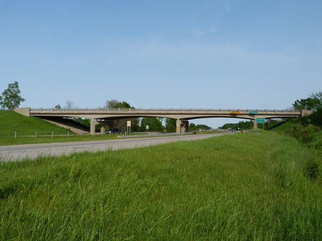
Clintonia Road is the creative name for the county line road made up from the names of the two counties, Clinton and Ionia. The bridge has rocker bearings at each pier and abutment, meaning that all bearings appear to be expansion bearings. This is different from the nearly identical bridge just east of this one on Jones Road. It is not known why the design is different on these two bridges built at the same time.
This bridge is of interest because it has been sensitively rehabilitated. Of particular note, deteriorated concrete railing posts were replaced with replicas that even still include the keyhole impression in the concrete, except for one pillar next to an abutment which for unknown reasons lacks the keyhole. The sides of the concrete pillars that face the freeway have a grey paint added, but the rest of the posts were not painted for unknown reasons. The roadway and deck was also reconstructed.
Because the rehabilitated replicated the posts design, it is a good rehabilitation in terms of historic preservation. This bridge is not considered an official historic bridge by the government, so it is nice to see they still made a point of restoring the original railing posts.
The only area of improvement might have been that instead of bolting modern Armco guardrails onto the original railings, Michigan's low profile two-tube type guardrail could have been mounted into the curb. This would have obstructed the view of the original railings less while also not requiring holes to be drilled into the original railing posts.
![]()
![]()
![]()
Coordinates (Latitude, Longitude):
Search For Additional Bridge Listings:
Bridgehunter.com: View listed bridges within 0.5 miles (0.8 kilometers) of this bridge.
Bridgehunter.com: View listed bridges within 10 miles (16 kilometers) of this bridge.
Additional Maps:
Google Streetview (If Available)
GeoHack (Additional Links and Coordinates)
Apple Maps (Via DuckDuckGo Search)
Apple Maps (Apple devices only)
Android: Open Location In Your Map or GPS App
Flickr Gallery (Find Nearby Photos)
Wikimedia Commons (Find Nearby Photos)
Directions Via Sygic For Android
Directions Via Sygic For iOS and Android Dolphin Browser
USGS National Map (United States Only)
Historical USGS Topo Maps (United States Only)
Historic Aerials (United States Only)
CalTopo Maps (United States Only)

© Copyright 2003-2026, HistoricBridges.org. All Rights Reserved. Disclaimer: HistoricBridges.org is a volunteer group of private citizens. HistoricBridges.org is NOT a government agency, does not represent or work with any governmental agencies, nor is it in any way associated with any government agency or any non-profit organization. While we strive for accuracy in our factual content, HistoricBridges.org offers no guarantee of accuracy. Information is provided "as is" without warranty of any kind, either expressed or implied. Information could include technical inaccuracies or errors of omission. Opinions and commentary are the opinions of the respective HistoricBridges.org member who made them and do not necessarily represent the views of anyone else, including any outside photographers whose images may appear on the page in which the commentary appears. HistoricBridges.org does not bear any responsibility for any consequences resulting from the use of this or any other HistoricBridges.org information. Owners and users of bridges have the responsibility of correctly following all applicable laws, rules, and regulations, regardless of any HistoricBridges.org information.
![]()