

View Information About HSR Ratings
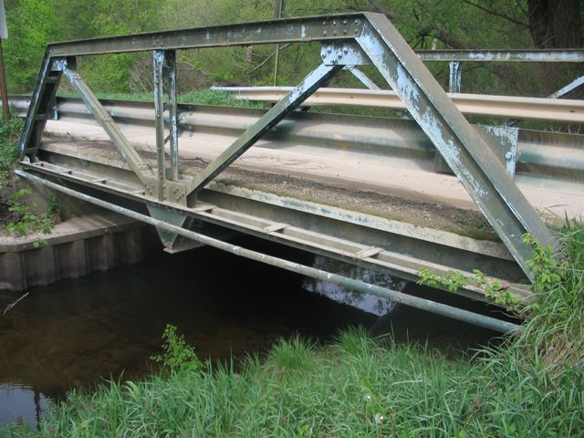
This bridge is an early (the bridge stylistically dates to roughly between 1910-1925) example of a truss bridge that uses bolts instead of rivets for all connections, and it is one of the only examples of a historic truss bridge with bolted connections in the entire state of Michigan, along with the other two truss bridges in Mason County. The bridge is also noteworthy for being one of the shortest trusses in Michigan. As a two panel Pratt, it also displays the smallest number of panels that a Pratt truss can have.
It is unclear why Mason County has three truss bridges with bolted connections while elsewhere in the state this design is nearly unheard of. Unfortunately, the bridge has been altered. The top chord and end post was insensitively repaired (presumably in the 1976 rehabilitation referenced in the bridge inventory) when new plate was welded directly on top of the original cover plate, with the top half of the rivets for the original cover plate being removed. In addition to reducing the historic integrity of the bridge, the plain, flat, rivet-less appearance of the top of these beams has reduced the historic feel and aesthetic qualities of the bridge.
The bridge is in a condition where rehabilitation and preservation should be feasible.
![]()
![]()
![]()
This historic bridge has been demolished. This map is shown for reference purposes only.
Coordinates (Latitude, Longitude):
Search For Additional Bridge Listings:
Bridgehunter.com: View listed bridges within 0.5 miles (0.8 kilometers) of this bridge.
Bridgehunter.com: View listed bridges within 10 miles (16 kilometers) of this bridge.
Additional Maps:
Google Streetview (If Available)
GeoHack (Additional Links and Coordinates)
Apple Maps (Via DuckDuckGo Search)
Apple Maps (Apple devices only)
Android: Open Location In Your Map or GPS App
Flickr Gallery (Find Nearby Photos)
Wikimedia Commons (Find Nearby Photos)
Directions Via Sygic For Android
Directions Via Sygic For iOS and Android Dolphin Browser
USGS National Map (United States Only)
Historical USGS Topo Maps (United States Only)
Historic Aerials (United States Only)
CalTopo Maps (United States Only)

© Copyright 2003-2026, HistoricBridges.org. All Rights Reserved. Disclaimer: HistoricBridges.org is a volunteer group of private citizens. HistoricBridges.org is NOT a government agency, does not represent or work with any governmental agencies, nor is it in any way associated with any government agency or any non-profit organization. While we strive for accuracy in our factual content, HistoricBridges.org offers no guarantee of accuracy. Information is provided "as is" without warranty of any kind, either expressed or implied. Information could include technical inaccuracies or errors of omission. Opinions and commentary are the opinions of the respective HistoricBridges.org member who made them and do not necessarily represent the views of anyone else, including any outside photographers whose images may appear on the page in which the commentary appears. HistoricBridges.org does not bear any responsibility for any consequences resulting from the use of this or any other HistoricBridges.org information. Owners and users of bridges have the responsibility of correctly following all applicable laws, rules, and regulations, regardless of any HistoricBridges.org information.
![]()