We Recommend:
Bach Steel - Experts at historic truss bridge restoration.
BridgeHunter.com Phase 1 is released to the public! - Visit Now
Falls River Soo Line Railroad Bridge

Primary Photographer(s): Nathan Holth
Bridge Documented: October 1, 2012
Railroad (Soo Line, Former Duluth South Shore and Atlantic) Over Falls River
L'Anse: Baraga County, Michigan: United States
Metal Continuous (Straight Chords) Rivet-Connected Double-Intersection Warren Deck Truss, Fixed
Not Available or Not Applicable
Not Available
Not Available
Not Available
2 Main Span(s)
Not Applicable

View Information About HSR Ratings
Bridge Documentation
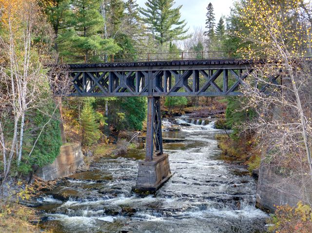
This is a highly unusual bridge. The bridge has two relatively short deck truss spans that carry the railroad over Falls River. Also unusual is that the panel length for the trusses is quite short. Another uncommon detail is that while the trusses make extensive use of angles, as opposed to built-up box beams that are more common on railroad truss bridges. This design, which is uncommon, but not unheard of, gives the bridge a somewhat two dimensional, plate-like look to it. Perhaps to compensate for the lighter design of the angles, the bridge's trusses are doubled on each side of the deck, almost like two pairs of trusses on each side of the railway. Finally, the bridge is continuous over the center bent. This is a very rare example of a continuous railroad truss in Michigan. It is also short example of a continuous truss, since continuous trusses tend to be used on large crossings. The bridge sits on abutments that are concrete, but also make use of unusual red brick abutments, visible behind the concrete. The brick abutments are likely from a previous bridge, and the concrete portions were likely added when the existing bridge was built. Red brick abutments are very unusual. Stone and concrete are the typical abutment types.
Plans in an archive at the Soo Line Historical Society are dated 1913, 1915, and 1916, so a ca. 1916 construction date is assumed for the bridge. Repair work was done in 1929. The previous bridge at this location was a 67 foot wooden structure built in 1903. Larry Easton at the Soo Line Historical Society explained some of the history of the bridge as follows. This bridge was designed by the Duluth South Shore & Atlantic, commonly known at the DSS&A or South Shore for short. This railroad ran from Duluth to approximately Marquette and Sault Ste. Marie. This route is very similar to that of the Soo Line (which itself was a subsidiary of the Canadian Pacific or CP) in this area of the U.P. Commonly it is said that the DSS&A was acquired by the Soo Line on December 31, 1960, but only to be technical the legal action was that the DSS&A acquired the Soo because the corporate structure of the DSS&A was more acceptable to the parent company, CP.
After the DSS&A and Soo merged in 1960, parts of each of the lines was abandoned as they became redundant in their parallel nature. Very fortunately the DSS&A line was the surviving line at L'Anse and the unique bridge has survived.
![]()
Photo Galleries and Videos: Falls River Soo Line Railroad Bridge
Bridge Photo-Documentation
Original / Full Size PhotosA collection of overview and detail photos. This gallery offers photos in the highest available resolution and file size in a touch-friendly popup viewer.
Alternatively, Browse Without Using Viewer
![]()
Bridge Photo-Documentation
Mobile Optimized PhotosA collection of overview and detail photos. This gallery features data-friendly, fast-loading photos in a touch-friendly popup viewer.
Alternatively, Browse Without Using Viewer
![]()
Maps and Links: Falls River Soo Line Railroad Bridge
Coordinates (Latitude, Longitude):
Search For Additional Bridge Listings:
Bridgehunter.com: View listed bridges within 0.5 miles (0.8 kilometers) of this bridge.
Bridgehunter.com: View listed bridges within 10 miles (16 kilometers) of this bridge.
Additional Maps:
Google Streetview (If Available)
GeoHack (Additional Links and Coordinates)
Apple Maps (Via DuckDuckGo Search)
Apple Maps (Apple devices only)
Android: Open Location In Your Map or GPS App
Flickr Gallery (Find Nearby Photos)
Wikimedia Commons (Find Nearby Photos)
Directions Via Sygic For Android
Directions Via Sygic For iOS and Android Dolphin Browser
USGS National Map (United States Only)
Historical USGS Topo Maps (United States Only)
Historic Aerials (United States Only)
CalTopo Maps (United States Only)

