

View Information About HSR Ratings
2020 Update: This bridge has been closed to all traffic.
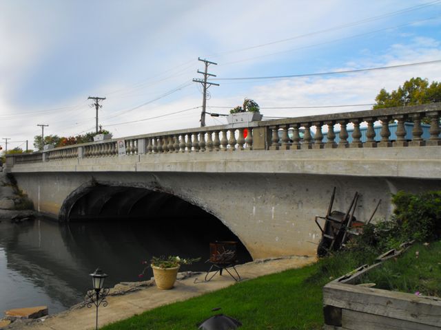
This bridge is extremely significant because it is an example of Wayne County's rare cantilevered concrete arch bridges. These unusual bridges defy attempts at classification, and have also been described as curved t-beam bridges instead of arch bridges, because the arch is actually formed of individual beams rather than a solid arch structure as is normally the case with closed spandrel arch bridges. Wayne County built a number of these bridges across the county, and several examples remain today. A cantilevered concrete arch does not function like a traditional arch. Traditional arch bridges require the arch to be a complete and connected arch to function. This arch bridge does not function in that way. Each half of each arch spans is a cantilever arm that is structurally independent from the other half of the arch in that span. These cantilever arms support a suspended span which is essentially a reinforced concrete slab in the center of the bridge. Looking closely at this bridge, two seams are visible on the side of the arch, marking where the cantilever arms end and the suspended span begins.
Information and Findings From Michigan Historic Bridge InventoryNarrative Description A small canal runs between the mainland and Swan Island, which is located a the base of the Trenton Canal, near where the Detroit River flows into Lake Erie. Gibraltar Road is carried to Swan Island by a 50-foot concrete cantilevered T-beam bridge. The suspended center section is nine feet long. Two 5.5 foot sidewalks flank the 38-foot roadway. The concrete balustrade railing has urn-shaped spindles. The bottom of the span's ten T-beams are curved to suggest an arched structure, making the bridge an attractive focal point for the surrounding village. A marina is to the north. When the county paved Gibralter Road in the early 1930s, it erected several new bridges along the route, including a reinforced-concrete cantilevered-arch span over a local canal. The 1931-1932 annual report of the Wayne County Road Commissioners noted that "this low sweeping arch bridge is in keeping with its surroundings and is one of the features which make Gibralter Road so attractive." Plans for the bridge (#403), prepared under the supervision of chief designer F. H. Chapin, are retained by the Wayne County Department of Public Works. This bridge is an excellent example of the attractive and creative designs developed by the Wayne County Road Commission. |
![]()
![]()
![]()
Coordinates (Latitude, Longitude):
Search For Additional Bridge Listings:
Bridgehunter.com: View listed bridges within 0.5 miles (0.8 kilometers) of this bridge.
Bridgehunter.com: View listed bridges within 10 miles (16 kilometers) of this bridge.
Additional Maps:
Google Streetview (If Available)
GeoHack (Additional Links and Coordinates)
Apple Maps (Via DuckDuckGo Search)
Apple Maps (Apple devices only)
Android: Open Location In Your Map or GPS App
Flickr Gallery (Find Nearby Photos)
Wikimedia Commons (Find Nearby Photos)
Directions Via Sygic For Android
Directions Via Sygic For iOS and Android Dolphin Browser
USGS National Map (United States Only)
Historical USGS Topo Maps (United States Only)
Historic Aerials (United States Only)
CalTopo Maps (United States Only)

© Copyright 2003-2026, HistoricBridges.org. All Rights Reserved. Disclaimer: HistoricBridges.org is a volunteer group of private citizens. HistoricBridges.org is NOT a government agency, does not represent or work with any governmental agencies, nor is it in any way associated with any government agency or any non-profit organization. While we strive for accuracy in our factual content, HistoricBridges.org offers no guarantee of accuracy. Information is provided "as is" without warranty of any kind, either expressed or implied. Information could include technical inaccuracies or errors of omission. Opinions and commentary are the opinions of the respective HistoricBridges.org member who made them and do not necessarily represent the views of anyone else, including any outside photographers whose images may appear on the page in which the commentary appears. HistoricBridges.org does not bear any responsibility for any consequences resulting from the use of this or any other HistoricBridges.org information. Owners and users of bridges have the responsibility of correctly following all applicable laws, rules, and regulations, regardless of any HistoricBridges.org information.
![]()