We Recommend:
Bach Steel - Experts at historic truss bridge restoration.
BridgeHunter.com Phase 1 is released to the public! - Visit Now
East River Road Bridge

Primary Photographer(s): Nathan Holth
Bridge Documented: October 11, 2009
Grosse Ile: Wayne County, Michigan: United States
Not Available or Not Applicable
24.0 Feet (7.3 Meters)
64.0 Feet (19.5 Meters)
24 Feet (7.32 Meters)
3 Main Span(s)
82200200000B010

View Information About HSR Ratings
Bridge Documentation
This bridge no longer exists!
Bridge Status: Demolished and replaced in 2019.View Archived National Bridge Inventory Report - Has Additional Details and Evaluation
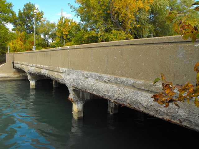
This bridge is not the most attractive bridge visually, nor is it the oldest bridge around. However the number of reinforced continuous concrete slab bridges of decent size which retain integrity is relatively low in the state. The Historic Bridge Inventory decided this bridge was eligible for listing in the National Register of Historic Places as a representative example. There are two bridges of this sort on Grosse Ile, both considered historic by the inventory. The bridge does indeed retain good integrity including a marble plaque cast into the guardrails. The guardrail design is plain, but unusual and unlike other bridges in the state. Wayne County Road Commission was noted for being innovative and trying new things, and as such historic bridges in Wayne County often bear little resemblance to bridges built during the same periods in other Michigan counties.
Information and Findings From Michigan Historic Sites OnlineNarrative Description Hickory Island is located near the mouth of the Detroit River. The East River Road Bridge crosses the North Hickory Canal to connect the north end of the island with marshy land at the southeast end of Grosse Ile. The bridge's solid concrete parapet railings, which contain large pebble aggregate, are trimmed near the top edge with an incised horizontal line. A similar line traces the level of the deck on the outside face of the railing. The railing ends curve at a 90-degree angle to follow the wing walls, which are perpendicular to the center line of the bridge. Metal guardrails edging the bridge approaches are attached to the inside ends of the railing. Piers have a row of square-section concrete posts with beveled edges.. Statement of Significance This bridge was built as part of a project to straighten and widen a section of the south end of East River Road. The road, which had run along the Detroit River, was moved to the west, and the existing timber bridge was removed. Plans for the new bridge were approved by chief designer Julian C. Mead in February 1944. The bridge was apparently not completed until the following year. The Wayne County Road Commission used the continuous concrete slab as a standard bridge plan in the years during and after World War II, presumably in part to minimize the use of steel, which was expensive and difficult to obtain during this period. The commission experimented with different forms for the precast concrete bent piles. On East River Road, the piles were octagon in section. This is one of the bridges that should be considered for National Register designation under Criteria A and C as an example of the evolution of the road commission's bridge design. |
![]()
Photo Galleries and Videos: East River Road Bridge
Bridge Photo-Documentation
Original / Full Size PhotosA collection of overview and detail photos. This gallery offers photos in the highest available resolution and file size in a touch-friendly popup viewer.
Alternatively, Browse Without Using Viewer
![]()
Bridge Photo-Documentation
Mobile Optimized PhotosA collection of overview and detail photos. This gallery features data-friendly, fast-loading photos in a touch-friendly popup viewer.
Alternatively, Browse Without Using Viewer
![]()
Maps and Links: East River Road Bridge
This historic bridge has been demolished. This map is shown for reference purposes only.
Coordinates (Latitude, Longitude):
Search For Additional Bridge Listings:
Bridgehunter.com: View listed bridges within 0.5 miles (0.8 kilometers) of this bridge.
Bridgehunter.com: View listed bridges within 10 miles (16 kilometers) of this bridge.
Additional Maps:
Google Streetview (If Available)
GeoHack (Additional Links and Coordinates)
Apple Maps (Via DuckDuckGo Search)
Apple Maps (Apple devices only)
Android: Open Location In Your Map or GPS App
Flickr Gallery (Find Nearby Photos)
Wikimedia Commons (Find Nearby Photos)
Directions Via Sygic For Android
Directions Via Sygic For iOS and Android Dolphin Browser
USGS National Map (United States Only)
Historical USGS Topo Maps (United States Only)
Historic Aerials (United States Only)
CalTopo Maps (United States Only)

