HistoricBridges.org Menu: HistoricBridges.org Menu:


We Recommend:
Bach Steel - Experts at historic truss bridge restoration.

HistoricBridges.org: Bridge Browser

Hines Drive Ann Arbor Road Bridge

Hines Drive Ann Arbor Road Bridge

Primary Photographer(s): Nathan Holth

Bridge Documented: December 15, 2010

View Photos
and Videos
View Maps
and Links

Facility Carried / Feature Intersected
Hines Drive Over Ann Arbor Road (Old M-14)
Location
Livonia: Wayne County, Michigan: United States
Structure Type
Concrete Rigid-Frame, Fixed
Construction Date and Builder / Engineer
1948 By Builder/Contractor: J. H. Baker and Sons of Port Huron, Michigan
Rehabilitation Date
Not Available or Not Applicable
Main Span Length
72.8 Feet (22.2 Meters)
Structure Length
72.8 Feet (22.2 Meters)
Roadway Width
48 Feet (14.63 Meters)
Spans
1 Main Span(s)
Inventory Number
82182101000S010

Historic Significance Rating (HSR)
View Information About HSR Ratings

Bridge Documentation

View Archived National Bridge Inventory Report - Has Additional Details and Evaluation

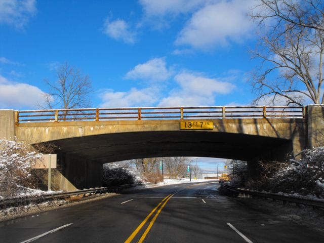
Hines Drive as well as some of the other roads and crossings in the various River Rouge parkways contain a number of old bridges of interest including concrete arch bridges. Nearly all of them have lost their original railings however. Specifically, a number of old rigid-frame bridges are along Hines Drive, but this is the only one that retains its original railings. This bridge also is among the earliest of the bridges built. The Historic Bridge Inventory thus highlighted this bridge among all the other old bridges on Hines Drive and as a result the bridge was listed in the National Register of Historic Places. The only noteworthy loss of historic integrity with this bridge is the fact that both plaques on the bridge have been stolen.

Rigid frame bridges are rare in Michigan. The state highway department only built a limited number of the bridge type. The conglomeration of county-designed rigid-frame bridges along Hines Drive are thus an anomaly among Michigan's collection of old and historic bridges.

The bridge appears to be in decent condition, however spalling on the underside of the superstructure needs to be repaired before it has a chance to deteriorate further. There also is a small tree growing out of a seemingly small gap in the abutment at the northeast corner of the bridge. Cutting this tree out would be something that county maintenance workers could do and it would help ensure that the bridge is not damaged by the growth of the tree.

Because the retention of original railings on this bridge is one of the key elements that distinguish this bridge, any future rehabilitation work should ensure that the original railings are preserved and not removed and replaced. As they are today, they could stand a fresh coat of paint to protect the steel from deterioration.

Information and Findings From Michigan Historic Bridge Inventory

Edward N. Hines Drive follows a pleasantly wooded parkway along the Rouge River. Just before it reaches Plymouth, it crosses over Ann Arbor Road (Old M-14). The railings on the rigid-frame structure consist of three rows of horizontal metal channels on metal box posts, with solid concrete parapets on the ends over the abutments. Sidewalks are on each side of the roadway, which carries two lanes of traffic in each direction and wide shoulders. Modern metal guardrail has been added to pipe posts between the southwest sidewalk and the road; a cable runs along the top of this rail.

By the 1920s, enlightened planners recognized that Wayne County’s rural character would quickly be transformed by the automobile. Leroy C. Smith, manager of the Wayne County Road Commission, warned that “an industrial center like Detroit is likely to place too much emphasis on the commercial highway and partially lose sight of the beautiful and restful places which still may be preserved.” The road commission sought to capitalize on the rivers winding through the county by edging them with parkways. In November 1929, Wayne Count Road Commissioner Edward N. Hines announced plans to develop a parkway system along the Rouge River and its branches. The parkway was soon named in his honor. In a paper delivered in February 1931, Leroy Smith explained that “the eventual plan is to include all the land along this stream from Detroit to Northville and from the top of the bank on one side of the river to the top of the bank on the opposite side.” He continued: “The plan includes a parkway drive following the stream through the lowland, with grade separations at important highway and railroad crossings...Such a drive, winding through a valley flanked with wooded slopes and rolling hills, will be unequaled as a parkway development.” The purpose of the parkway was two-fold: to decrease traffic congestion on other routes, and to server “the individuals who need fresh air, sunshine, and care free recreation.”

The commission’s first priority was to procure the necessary land. It then turned to developing the road and other amenities. Work first concentrated on a section of the river valley between Northville and Plymouth, in the northwestern corner of Wayne County. The parkway was established as far east as Newburgh Road before World War II. By the end of the war, the commission was eager to extend the route from Newburgh Road to its eastern terminus at Ford Road and Rouge Park. The commission had acquired the land and designed eighteen bridges to serve the parkway and intersecting roads. The structures, which were estimated to cost $1.5 million to erect, included ten highway grade separations, six river crossings, and two bridges that crossed both the river and the parkway.

One of the first highway grade separation to be completed was over Ann Arbor Road. The structure was built as a federal-aid secondary project, a cooperative venture between the federal government, the state highway department, and the Wayne County Road Commission. It was erected by contractor J.H. Baker and Sons in 1947. The county road commission’s 1946-1947 annual report explained that an important consideration rushed the construction: “This structure was completed to an extent that Ann Arbor Road traffic could pass under the structure before the football season at Ann Arbor.” Problems with obtaining steel, labor strikes and other obstacles delayed completion of the bridge, so the contractor was given a contract extension until spring 1948.

Divider

Photo Galleries and Videos: Hines Drive Ann Arbor Road Bridge


View Photo Gallery

Bridge Photo-Documentation

Original / Full Size Photos
A collection of overview and detail photos. This gallery offers photos in the highest available resolution and file size in a touch-friendly popup viewer.
Alternatively, Browse Without Using Viewer

Divider

View Photo Gallery

Bridge Photo-Documentation

Mobile Optimized Photos
A collection of overview and detail photos. This gallery features data-friendly, fast-loading photos in a touch-friendly popup viewer.
Alternatively, Browse Without Using Viewer

Divider

Maps and Links: Hines Drive Ann Arbor Road Bridge

Coordinates (Latitude, Longitude):

Search For Additional Bridge Listings:

Bridgehunter.com: View listed bridges within 0.5 miles (0.8 kilometers) of this bridge.

Bridgehunter.com: View listed bridges within 10 miles (16 kilometers) of this bridge.

HistoricBridges.org Bridge Browser: View listed bridges within 0.5 miles (0.8 kilometers) of this bridge.

HistoricBridges.org Bridge Browser: View listed bridges within 10 miles (16 kilometers) of this bridge.

2021 National Bridge Inventory: View listed bridges within 0.5 miles (0.8 kilometers) of this bridge.

Additional Maps:

Google Maps

Google Streetview (If Available)

Bing Maps

OpenStreetMap

GeoHack (Additional Links and Coordinates)

Apple Maps (Via DuckDuckGo Search)

Apple Maps (Apple devices only)

MapQuest

HERE We Go Maps

ACME Mapper

Waze Map

Android: Open Location In Your Map or GPS App

Flickr Gallery (Find Nearby Photos)

Wikimedia Commons (Find Nearby Photos)

Directions Via Sygic For Android

Directions Via Sygic For iOS and Android Dolphin Browser

USGS National Map (United States Only)

Historical USGS Topo Maps (United States Only)

Historic Aerials (United States Only)

CalTopo Maps (United States Only)


Divider
 
Home Top

Divider

About - Contact

© Copyright 2003-2024, HistoricBridges.org. All Rights Reserved. Disclaimer: HistoricBridges.org is a volunteer group of private citizens. HistoricBridges.org is NOT a government agency, does not represent or work with any governmental agencies, nor is it in any way associated with any government agency or any non-profit organization. While we strive for accuracy in our factual content, HistoricBridges.org offers no guarantee of accuracy. Information is provided "as is" without warranty of any kind, either expressed or implied. Information could include technical inaccuracies or errors of omission. Opinions and commentary are the opinions of the respective HistoricBridges.org member who made them and do not necessarily represent the views of anyone else, including any outside photographers whose images may appear on the page in which the commentary appears. HistoricBridges.org does not bear any responsibility for any consequences resulting from the use of this or any other HistoricBridges.org information. Owners and users of bridges have the responsibility of correctly following all applicable laws, rules, and regulations, regardless of any HistoricBridges.org information.

Admin Login

Divider