

View Information About HSR Ratings
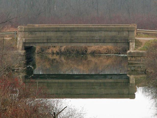
This bridge is a great example of Michigan's design of through girder. It retains excellent historic integrity, with the exception of stolen plaques. There is no posted weight limit, nor is there any notable spalling on the bridge. Modern railings provide an approach to the bridge, but they are not bolted to the concrete girders, and they are only present on one end of each side of the bridge. This is unlike the Hastings Road Bridge, which has the more frequently seen mounting technique, that obscures the view of part of the bridge.
An old, large, and ugly pipe is mounted to the north side of this bridge. There was quite a bit of construction equipment near this bridge, and it looked like they were preparing to perhaps replace the pipe or do work on it somehow. Hopefully it is the pipe it is replacing and not the bridge! If they do replace the pipe, perhaps burying it underground, it would make this bridge quite a bit more photogenic. Views beside the bridge were easier from the north side, although anyone who explores the railroad grade will find that the nearby railroad bridge to the south provides impressive side views.
Between 2006 and 2009, the meager Armco railings present approaching the bridge on the southwest and northeast corners was removed and larger and much more extensive Armco railings were but on leading up to the bridge from some distance away. The use of crash-resistant railing is often important for motorist safety, and well as for maintaining the safety and integrity of the historic bridge, however HistoricBridges.org does not support or advocate the choice of Armco railing because it is not aesthetically appealing compared to other crash tested alternatives. HistoricBridges.org also strongly discourages drilling holes into the original concrete of the historic bridge for the purpose of attaching these railings, which is what was done in this case. By drilling holes in the concrete, they have opened the door for moisture to enter the historic bridge and do damage which in some cases may be irreversible. They have also needlessly damaged and destroyed original bridge material by drilling holes in the bridge. Alternative ways to secure the roadway and bridge should have been considered.
![]()
![]()
Coordinates (Latitude, Longitude):
Search For Additional Bridge Listings:
Bridgehunter.com: View listed bridges within 0.5 miles (0.8 kilometers) of this bridge.
Bridgehunter.com: View listed bridges within 10 miles (16 kilometers) of this bridge.
Additional Maps:
Google Streetview (If Available)
GeoHack (Additional Links and Coordinates)
Apple Maps (Via DuckDuckGo Search)
Apple Maps (Apple devices only)
Android: Open Location In Your Map or GPS App
Flickr Gallery (Find Nearby Photos)
Wikimedia Commons (Find Nearby Photos)
Directions Via Sygic For Android
Directions Via Sygic For iOS and Android Dolphin Browser
USGS National Map (United States Only)
Historical USGS Topo Maps (United States Only)
Historic Aerials (United States Only)
CalTopo Maps (United States Only)

© Copyright 2003-2026, HistoricBridges.org. All Rights Reserved. Disclaimer: HistoricBridges.org is a volunteer group of private citizens. HistoricBridges.org is NOT a government agency, does not represent or work with any governmental agencies, nor is it in any way associated with any government agency or any non-profit organization. While we strive for accuracy in our factual content, HistoricBridges.org offers no guarantee of accuracy. Information is provided "as is" without warranty of any kind, either expressed or implied. Information could include technical inaccuracies or errors of omission. Opinions and commentary are the opinions of the respective HistoricBridges.org member who made them and do not necessarily represent the views of anyone else, including any outside photographers whose images may appear on the page in which the commentary appears. HistoricBridges.org does not bear any responsibility for any consequences resulting from the use of this or any other HistoricBridges.org information. Owners and users of bridges have the responsibility of correctly following all applicable laws, rules, and regulations, regardless of any HistoricBridges.org information.
![]()