

View Information About HSR Ratings
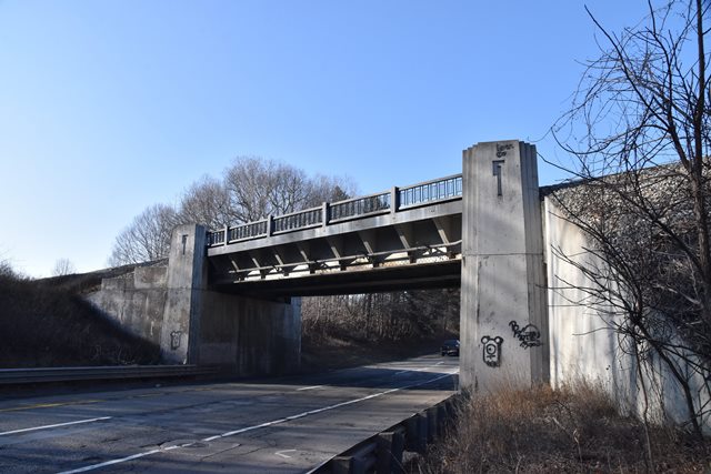
This is perhaps one of the oldest known bridges on I-94 in Michigan since it is a repurposed former US-12 bridge. The location is interesting because immediately east of this bridge is the exit for old US-12. Multiple alignments are discernable on maps, with this bridge being one old US-12 alignment, and another being the road that extends southwest of the aforementioned exit. Since US-12 was a two lane highway, the 1936 bridge was only suitable for a single direction of I-94 traffic, and to reuse this bridge, I-94 westbound had to follow the alignment of old US-12. For eastbound I-94, a new road was needed. This new road was not constructed right next to the westbound road, and instead bows out to the south and crosses the railroad as a highway over railroad overpass. It is a unique pairing of bridges and a rare example of a pre-interstate bridge still present on an interstate. The bridge retains good historic integrity including type R4 railing panels and keystone details on the abutments.
The only plaque on this bridge is on the median side of the expressway. I-94 is an extremely busy expressway for its size and has a ton of trucks. It was not possible to get a safely access and get a good photo of the plaque and only a distance shot where the builder is barely visible is currently available.
This bridge is tagged with the following special condition(s): Unorganized Photos
![]()
![]()
![]()
Coordinates (Latitude, Longitude):
Search For Additional Bridge Listings:
Bridgehunter.com: View listed bridges within 0.5 miles (0.8 kilometers) of this bridge.
Bridgehunter.com: View listed bridges within 10 miles (16 kilometers) of this bridge.
Additional Maps:
Google Streetview (If Available)
GeoHack (Additional Links and Coordinates)
Apple Maps (Via DuckDuckGo Search)
Apple Maps (Apple devices only)
Android: Open Location In Your Map or GPS App
Flickr Gallery (Find Nearby Photos)
Wikimedia Commons (Find Nearby Photos)
Directions Via Sygic For Android
Directions Via Sygic For iOS and Android Dolphin Browser
USGS National Map (United States Only)
Historical USGS Topo Maps (United States Only)
Historic Aerials (United States Only)
CalTopo Maps (United States Only)

© Copyright 2003-2026, HistoricBridges.org. All Rights Reserved. Disclaimer: HistoricBridges.org is a volunteer group of private citizens. HistoricBridges.org is NOT a government agency, does not represent or work with any governmental agencies, nor is it in any way associated with any government agency or any non-profit organization. While we strive for accuracy in our factual content, HistoricBridges.org offers no guarantee of accuracy. Information is provided "as is" without warranty of any kind, either expressed or implied. Information could include technical inaccuracies or errors of omission. Opinions and commentary are the opinions of the respective HistoricBridges.org member who made them and do not necessarily represent the views of anyone else, including any outside photographers whose images may appear on the page in which the commentary appears. HistoricBridges.org does not bear any responsibility for any consequences resulting from the use of this or any other HistoricBridges.org information. Owners and users of bridges have the responsibility of correctly following all applicable laws, rules, and regulations, regardless of any HistoricBridges.org information.
![]()