We Recommend:
Bach Steel - Experts at historic truss bridge restoration.
BridgeHunter.com Phase 1 is released to the public! - Visit Now
Lincoln Road Bridge
Riverdale Bridge

Primary Photographer(s): Nathan Holth
Bridge Documented: Winter 2006 and March 15, 2009
Rural: Gratiot County, Michigan: United States
1922 By Builder/Contractor: Walter Willets and Engineer/Design: Michigan State Highway Department
Not Available or Not Applicable
90.0 Feet (27.4 Meters)
90.0 Feet (27.4 Meters)
20 Feet (6.1 Meters)
1 Main Span(s)
29200019000B010

View Information About HSR Ratings
Bridge Documentation
This bridge no longer exists!
View Archived National Bridge Inventory Report - Has Additional Details and Evaluation
Learn about Michigan's Unique Concrete Camelback Bridges
This historic bridge was demolished and replaced in 2009!
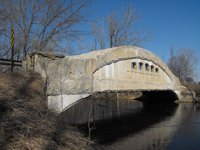
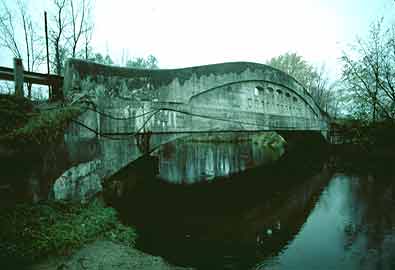
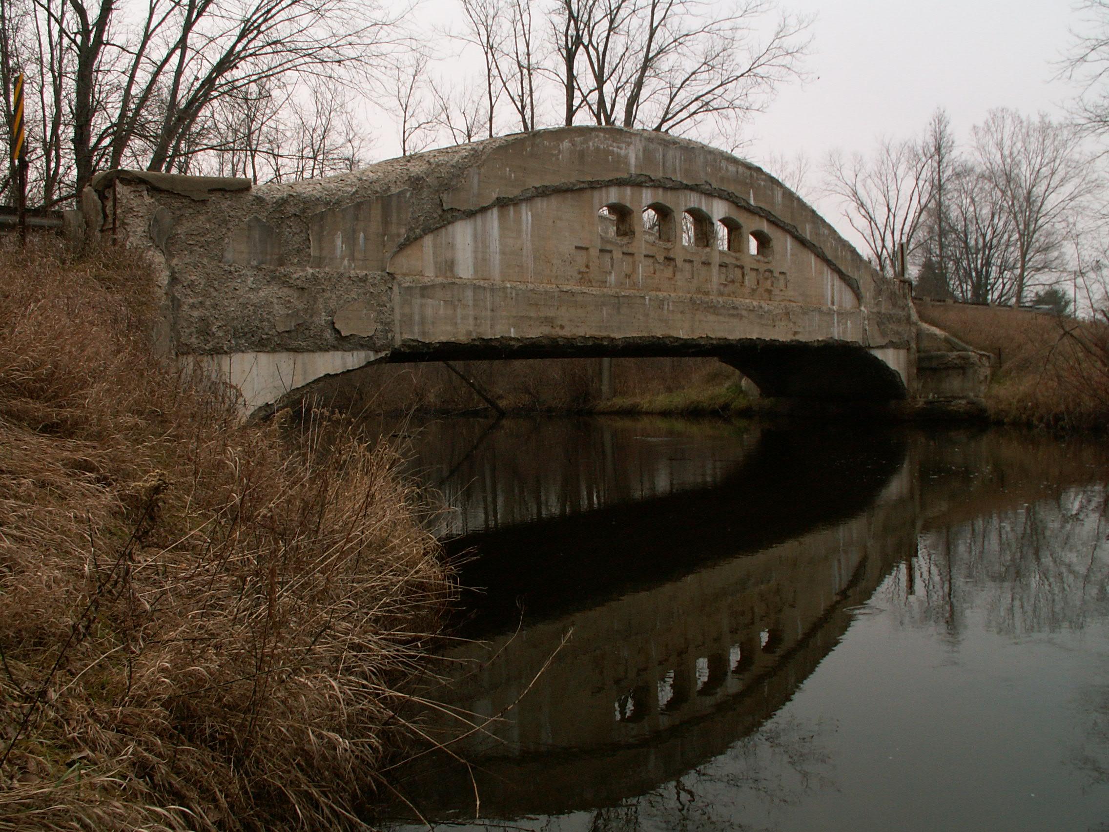
This is perhaps the most severely spalling bridge to appear on this website. Perhaps a bad concrete mix in 1922, coupled with the use of salt on roads today, have combined to bring about the sad fate of this bridge. Oddly though, for all this spalling, the bridge's structure is apparently in fair condition, as no weight limit is posted. The spalling is unimaginable. The shape of the decorative pierced openings on the girders have deformed, nearly the entire top layer of cement on the outmost halves of the girder is gone. The ends of the bridge were patched at some time, and the spalling has continued beneath this patching, and the patch itself has been breaking up. The spalling, which turns solid concrete into a pile of stones and dust have become suitable for grass to begin growing on the girders! Perhaps the only good that has come of this is an opportunity to see inside a reinforced concrete bridge of the 1920s. The main reinforcing rods (apparently acting like the top chord) are quite large, and look somewhat like the decorative twisted steel that uninformed companies call "wrought iron". Smaller, yet similar rods run vertically in the girders, acting like vertical members. Finally, tiny wire-like reinforcing rods are visible in spots as well, for holding smaller portions of concrete together.
This bridge is noteworthy for not only its early 1922 construction date, but also for being a large 90 foot span that also features a notable skew. Most of the 90 foot plan structures are not skewed.

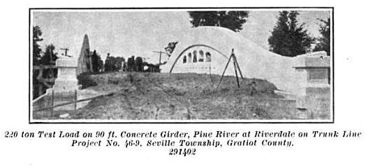
The Lincoln Road Bridge was built to serve the M-46 state trunkline, which originally ran along Lincoln Road in this area. The 1922 Biennial Report of the Michigan State Highway Department shows a 220 Ton Test Load placed on the deck of the bridge, a stunning image that shows the shear strength of Michigan's concrete camelback bridges.
Among Gratiot County's three curved chord through girder bridges, this was the only one to appear on MDOT's website. This is apparently because of its older construction date. Indeed the bridge is significant as one of the first examples of its type to be built, and is one of the oldest remaining today. But it is worth noting that this structure type was only built for about a decade. Even the last girder to be built in Michigan was under ten years newer than this bridge. With perhaps only a few dozen of this structure type remaining, and that number decreasing, all of these bridges are significant, including the others in Gratiot County. Getting Gratiot County to preserve all three of their concrete girder bridges might prove difficult. Perhaps they might agree to preserve one of them however. If this was the case, logic would initially seem to suggest that the Lincoln Road Bridge should be that one, as it was determined to have the most historic significance. However, it may be pertinent, to suggest that the St. Charles Road Bridge might be the way to go. The difference of historic important between a handful or years, versus the structural quality of the actual structure suggest that the St. Charles Road Bridge is more important today. Restoring the St. Charles Road Bridge would be less costly, and because less concrete patching would be needed on its comparatively pristine surface, it would retain a greater degree of historic integrity. It is quite unfortunate, but visually, there is very little left of the Lincoln Road Bridge to preserve. The damage has already been done for the most part. On the other hand, if funding worked more effectively in Michigan, repairs would be less costly that demolition and replacement, and then it would be sensible to restore all three of Gratiot County's girder bridges!
MDOT's explanation for this bridge answers a question some people might have. Usually with a girder bridge, such as a plate girder, one expects to see the floor beams running under the deck between the girders. However, with most of these concrete girder bridges, those girders are cast integrally with the deck itself, rendering them invisible. Some bridges like the Griswold Road Bridge actually has these beams visible.

Above: Replacement Bridge. Photo Credit: Gratiot County Road Commission
Information and Findings From Michigan Historic Bridge Inventory
Narrative Description Constructed in 1921-1922 from a MSHD standard design, the structure is comprised of a pair of 90-foot, arched concrete through girders that rest on angled concrete brackets cantilevered from the skewed concrete abutments. A dozen concrete floor beams span between the two girders; these are cast integrally with the 20-foot-wide concrete deck. The arched girders feature typical MSHD detailing, with spandrel walls punctuated by five small arched cutouts aligned over a series of arched recessed panels. The lack of corbeled bulkheads at the girders' ends illustrates the bridge's early construction. Although the Lincoln Road Bridge suffers from severe concrete spalling and Armco guardrails have been installed at the approaches, it retains a relatively high degree of structural integrity. Statement of Significance The Michigan State Highway Department first developed plans for a long-span concrete through girder bridge with arched girders on cantilevered brackets in the 1921-22 biennium. "These designs have curved top chords and bottom chord brackets," MSHD reported in its Ninth Biennial Report, making them suitable for relatively long-span applications. The first curved-chord girder was a 90-foot span built in 1922 over the Raisin River at Tecumseh. This was followed in the 1920s by a series of curved girders used in single-span or multiple-span configurations. Among the earliest of these new bridges was the span that MSHD designed in 1921 for the Pine Creek crossing in Gratiot County. The Lincoln Road structure, like the Tecumseh Bridge, featured a 90-foot span. Since its completion in 1922, the Lincoln Road Bridge has functioned in place, essentially unaltered. With its 1921-1922 construction date and its 90-foot span, it is today noteworthy as on of the earliest and longest remaining examples in Michigan of the MSHD-designed, arched through girder. |
![]()
Photo Galleries and Videos: Lincoln Road Bridge
2009 Overview Photos
Original / Full Size PhotosA collection of overview photos, taken March 15, 2009. This gallery offers photos in the highest available resolution and file size in a touch-friendly popup viewer.
Alternatively, Browse Without Using Viewer
![]()
2009 Overview Photos
Mobile Optimized PhotosA collection of overview photos, taken March 15, 2009. This gallery features data-friendly, fast-loading photos in a touch-friendly popup viewer.
Alternatively, Browse Without Using Viewer
![]()
Winter 2006 Bridge Photo-Documentation
A collection of overview and detail photos, taken Winter 2006. This photo gallery contains a combination of Original Size photos and Mobile Optimized photos in a touch-friendly popup viewer.Alternatively, Browse Without Using Viewer
![]()
Maps and Links: Lincoln Road Bridge
This historic bridge has been demolished. This map is shown for reference purposes only.
Coordinates (Latitude, Longitude):
Search For Additional Bridge Listings:
Bridgehunter.com: View listed bridges within 0.5 miles (0.8 kilometers) of this bridge.
Bridgehunter.com: View listed bridges within 10 miles (16 kilometers) of this bridge.
Additional Maps:
Google Streetview (If Available)
GeoHack (Additional Links and Coordinates)
Apple Maps (Via DuckDuckGo Search)
Apple Maps (Apple devices only)
Android: Open Location In Your Map or GPS App
Flickr Gallery (Find Nearby Photos)
Wikimedia Commons (Find Nearby Photos)
Directions Via Sygic For Android
Directions Via Sygic For iOS and Android Dolphin Browser
USGS National Map (United States Only)
Historical USGS Topo Maps (United States Only)
Historic Aerials (United States Only)
CalTopo Maps (United States Only)


