Information and Findings From
Michigan Historic Bridge Inventory
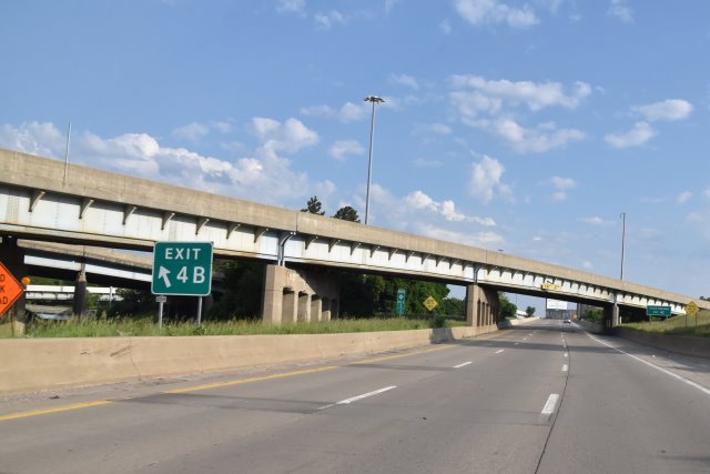
Bridge 1 (And General Discussion)
M-10 NB over
I-94 (#000000000011195)
Built: 1953
Status: Open, no restriction
Design: Steel Stringer/Multi-beam or
girder
This bridge is part of the interchange between I-94 (Edsel Ford Expressway) and M-10 (John C. Lodge Expressway). The
original railings have been replaced by a solid concrete Jersey
barricade. Piers supporting the bridge's six steel-stringer spans
consist of four square-section posts; each post is trimmed with an
incised line to form a "capital." The posts are separated by slightly
pointed, flat-arch openings.
In the early 1940s, the Wayne County
Board of Supervisors directed its road commission to study the
feasibility of a north-south expressway as a post-World War II
construction project. The route would complement an east-west crosstown
freeway (later the Edsel Ford Expressway/Interstate 94), which was also
being planned. Engineers soon narrowed the prospective north-south route
to a nine-mile corridor generally following the course of Hamilton and
Sixth, a densely developed urban area. By January 1944, the road
commission presented the Detroit Common Council with a preliminary plan
for a limited-access road with three 12-foot lanes in each direction
divided by a 14-foot median. Entrance and exit ramps were placed at
approximately quarter-mile intervals. The road was designed to carry
9,000 vehicles per hour. Local traffic was served by 30-foot-wide
one-way service drives flanking the depressed expressway, and by
overpass bridges every five or six blocks.
The feasibility of the
project was greatly enhanced by the Federal Aid Law of 1944, which
permitted federal funds, for the first time, to pay for highway
construction in urban areas. The estimated price tag for the Lodge was
$50 million. The state highway department, which controlled the federal
funds, reached an agreement with Wayne County and the city of Detroit
whereby federal aid would cover 50 percent of the highway's cost. The
state would pick up another 25 percent, with the remainder split evenly
between the county and the city. Since the expressway was to become part
of the state trunkline system, the state highway department would
normally have been responsible for its design and construction. The
capacity of the state's engineering department, however, was stretched
by work on the Ford Expressway, as well as other projects throughout the
state. As a result, the Wayne County Road Commission took on the
challenge of designing and building the Lodge, except for the section
between Holden and Merrick avenues, where the Lodge and Ford
intersected. The county had gained experience in freeway construction by
developing the Davison Expressway in 1940s, and working with the state
on the Detroit Industrial Expressway during the war. Under an agreement
between the state and the county, the state let the contracts for both
the Ford and Lodge expressways, but the county prepared the plans and
over saw the construction of the Lodge.
Construction did not
begin until after the end of World War II. The first phase extended
north from First Street and Jefferson Avenue to Pallister and Hamilton
avenues. The Third Street Bridge was ready by November 1948, and the
Milwaukee Avenue Bridge opened in 1948, but other developments in this
section proved costly and complicated. Dealing with railroad lines was a
particular challenge, since rail traffic could not be interrupted by
road construction. Temporary trestles carried trains for two years while
permanent bridges were erected. Relocating water, sewer and other
utility lines sometimes took longer than anticipated. In addition,
right-of-way acquisition costs were high, depleting the amount of money
available for work on the expressway. While progress was delayed south
of Pallister, the county extended its efforts to the north, opening the
Forest Avenue Bridge in 1949, and the Warren Avenue Bridge in 1950.
In October 1950, the first half-mile section of the expressway, the
northbound lanes between Holden and Pallister, was put in service. Steel
shortages delayed construction of pedestrian and vehicular bridges,
including the interchange with the Edsel Ford Expressway, in the
following year, but material was once again arriving by November 1951.
The project was significantly expedited in January 1952, when the
proceeds from an $80 million bond issue became available to fund
construction of both expressways. Previously, work had been initiated
based on actual cash available. With the new infusion of funds, the
state highway department let contracts for 12 bridges over the Lodge in
the first seven months of 1952, along with right-of-way demolition and
other construction contracts. Plans called for opening the section south
from Holden to Grand River Avenue before the onset of winter, but the
official ribbon cutting did not occur until 14 January 1953. Traffic was
allowed south from Grand River to Howard Street in September 1954, and a
two-mile section north from the Ford Expressway interchange to Glendale
in Highland Park opened with much fanfare in October 1955. State Highway
Commissioner Charles Ziegler cut the ribbon for the latter section. The
ceremony included a speech by Charles D. Curtiss, Commissioner of the
U.S. Bureau of Public Roads. Curtiss, a Michigan native who had once
worked for the state highway department, remarked: "It is fitting that
this dynamic city, which has had such an influence on motor transport,
should have this expressway system." Wayne County Engineer Leroy C.
Smith added that "the only reason for a dedication is to look ahead -
this system is a model for what is to come in Wayne County and in
Michigan." The expressway was christened in honor of John C. Lodge, a
Detroit civic leader who had served in a number of public roles,
including city council member and mayor.
Bridge 2
M-10 SB over I-94 (#000000000011192)
Built: 1953
Status: Open, no restriction
Design: Steel Stringer/Multi-beam or
girder
Bridge 3
M-10 SB over I-94 RAMP FROM M-10
(#000000000011197) South Lodge to East 94
Built: 1953
Status: Open, no restriction
Design: Steel Stringer/Multi-beam or girder
This bridge is part
of the interchange between I-94 (Edsel Ford Expressway) and M-10 (John
C. Lodge Expressway). The structure carries northbound M-10 over a ramp
that links southbound traffic on M-10 with eastbound I-94. The
three-span steel-girder structure in skewed. The original metal railings
have been replaced by modern solid concrete barricades.
Bridge 4
I-94 WB over I-94 RAMP FROM M-10
(#000000000011196) South Lodge to East 94
Built: 1955
Status: Open, no restriction
Design: Steel Stringer/Multi-beam or girder
This bridge is part
of the interchange between I-94 (Edsel Ford Expressway) and M-10 (John
C. Lodge Expressway). The skewed, three-span, steel-girder structure
carries westbound vehicles on I-94 over a ramp connecting southbound
traffic on M-10 with eastbound I-94. Solid concrete barricades replaced
the standard state highway department metal railings and posts that once
edged the road's three lanes. Original stepped concrete parapets at the
railing ends survive.
Bridge 5
I-94WB RMP TO M-10 over I-94 EB & M-10
NB (#000000000011194)
Built: 1953
Status: Open, no restriction
Design: Steel Stringer/Multi-beam or girder
This bridge is part
of the interchange between I-94 (Edsel Ford Expressway) and M-10 (John
C. Lodge Expressway). It transfers traffic exiting from the left lane of
westbound I-94 to the left lane of southbound M-10, passing over
eastbound I-94, northbound M-10, a ramp between northbound M-10 and
westbound I-94, and a ramp between southbound M-10 and eastbound I-94.
The structure, which forms a 90-degree curve, is comprised of eleven
spans, each with five steel-plate deck girders. The girders are built up
from the plates and angles. The concrete deck extends beyond the outside
girder, supported by steel brackets. The original railings, single
horizontal metal rails on a relatively low metal and concrete base, have
been supplanted by solid concrete Jersey barricades. Piers supporting
the spans consist of four square-section posts; each post is trimmed
with an incised line to form a "capital." The posts are separated by
slightly pointed, flat-arch openings.
Bridge 6
I-94EB RMP TO M-10 over I-94 WB & M-10
SB (#000000000011193)
Built: 1953
Status: Open, would be posted or
closed except for temporary shoring
Design: Steel Stringer/Multi-beam
or girder
This bridge is part of the interchange between I-94 (Edsel
Ford Expressway) and M-10 (John C. Lodge Expressway). It transfers
traffic exiting from the left lane of eastbound I-94 to the left lane of
northbound M-10, passing over westbound I-94, southbound M-10, a ramp
between northbound M-10 and westbound I-94, and a ramp between
southbound M-10 and eastbound I-94. The structure, which forms a
90-degree curve, is comprised of eleven spans, each with five
steel-plate deck girders. The girders, which are built up from plates
and angles, are braced by crossed angles. The concrete deck extends
beyond the outside girder, supported by steel brackets. The original
railings, single horizontal metal rails on a relatively low concrete and
metal base, have been supplanted by solid concrete Jersey barricades.
Piers supporting the spans consist of four square-section posts; each
post is trimmed with an incised line to form a "capital." The posts are
separated by slightly pointed, flat-arch openings.
Bridge 7
I-94 EB over I-94 RAMP TO M-10
(#000000000011191) EB I-94 Over West I-10 to West I-94 App
Built: 1955
Status: Open, no restriction
Design: Steel Stringer/Multi-beam or girder
This bridge is part
of the interchange between I-94 (Edsel Ford Expressway) and M-10 (John
C. Lodge Expressway). The three-span, steel-girder structure carries
eastbound vehicles on I-94 over a ramp connection northbound traffic on
M-10 with westbound I-94. Solid concrete barricades have replaced the
standard state highway department metal railings and posts that once
edged the road's three lanes. Original stepped concrete parapets at the
railing end survive.
Bridge 8
M-10 EB over I-94 RAMP
(#000000000011190) EB I-94 Over West I-10 to West I-94 App
Built: 1953
Status: Open, no restriction
Design: Steel Stringer/Multi-beam or girder
|