

View Information About HSR Ratings
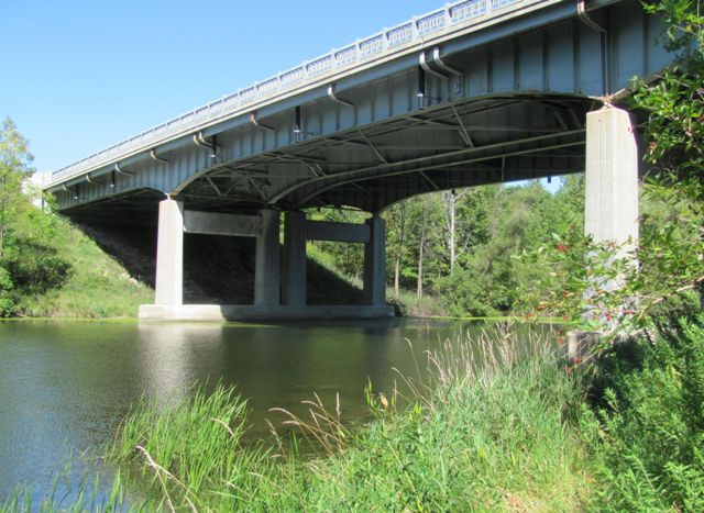
This bridge is a good example of a cantilevered deck plate girder, a design that the Michigan State Highway Department used in the mid-20th Century to cross larger obstacles. The design has distinctive variable depth girders that identify the design.
Information and Findings From Michigan Historic Bridge InventoryNarrative Description This long-span steel bridge crosses the Pentwater River at the northern periphery of Hart, the Oceana County seat. Carrying U.S. Highway 31, the West Michigan Pike, this graceful deck girder structure extends 270 feet. It is configured with two 84-foot anchor spans that cantilever over the piers. The abutments have stepped concrete wingwalls; the spill-through piers feature battered columns with concrete corbeling and straight cross-beams. The variable-depth girders are made up of steel plate webs, with riveted angle flanges and web stiffeners. They carry the 56-foot-wide concrete deck. Completed in 1954, the Pentwater River Bridge has since carried vehicular traffic, with only maintenance-related repairs. By the early 1950s the existing US-31 bridge over the Pentwater River in Hart had become a serious bottleneck to traffic. In 1954 engineers for the Michigan State Highway Department designed a replacement structure. The proposed Pentwater Bridge was actually configured as two side-by-side structures - each with its own columns, girders and floor system - separated by a "four-foot divider strip." MSHD designated the bridge a Federal Aid project, solicited competitive bids for its construction and awarded the contract to Gene Fewell. Fewell completed the Pentwater Bridge the next year for $266,564. Since then it has carried vehicular traffic in essentially unaltered condition. The bridge's steel girder configuration is one that MSHD used extensively for bridges in the 1930s and 1940s. Although the highway department had delineated a standard steel stringer design as early as the 1905-1906 biennium, the relatively shallow I-beams that were being fabricated by the steel mills limited their span - first to 30 feet, later to 45 feet. When the mills began producing deeper beams in the 1920s, MSHD could extend the spans of its steel stringer bridges "When this type of structure was first put in use," MSHD stated in 1930, "rolled sections of sufficient strength were not available for spans greater than about forty-five feet. It was necessary, therefore, to use relatively shallow fabricated deck girders for spans greater than forty-five feet. Rather recently, however, steel mills have improved their methods and are able to furnish rolled section which, on proper spacing, are suitable for spans up to sixty feet." For its long-span bridges in high-traffic locations, MSHD often substituted plate girders for rolled beams, and for its longest girder structures, it cantilevered the channel spans from arms of the adjacent anchor spans. The Pentawater River Bridge in Oceana County is noteworthy among these cantilevered girder bridges for its relatively long span and its well-preserved condition. A pivotal crossing on a regionally important highway, it is a significant transportation-related resource. |
![]()
![]()
![]()
Coordinates (Latitude, Longitude):
Search For Additional Bridge Listings:
Bridgehunter.com: View listed bridges within 0.5 miles (0.8 kilometers) of this bridge.
Bridgehunter.com: View listed bridges within 10 miles (16 kilometers) of this bridge.
Additional Maps:
Google Streetview (If Available)
GeoHack (Additional Links and Coordinates)
Apple Maps (Via DuckDuckGo Search)
Apple Maps (Apple devices only)
Android: Open Location In Your Map or GPS App
Flickr Gallery (Find Nearby Photos)
Wikimedia Commons (Find Nearby Photos)
Directions Via Sygic For Android
Directions Via Sygic For iOS and Android Dolphin Browser
USGS National Map (United States Only)
Historical USGS Topo Maps (United States Only)
Historic Aerials (United States Only)
CalTopo Maps (United States Only)

© Copyright 2003-2026, HistoricBridges.org. All Rights Reserved. Disclaimer: HistoricBridges.org is a volunteer group of private citizens. HistoricBridges.org is NOT a government agency, does not represent or work with any governmental agencies, nor is it in any way associated with any government agency or any non-profit organization. While we strive for accuracy in our factual content, HistoricBridges.org offers no guarantee of accuracy. Information is provided "as is" without warranty of any kind, either expressed or implied. Information could include technical inaccuracies or errors of omission. Opinions and commentary are the opinions of the respective HistoricBridges.org member who made them and do not necessarily represent the views of anyone else, including any outside photographers whose images may appear on the page in which the commentary appears. HistoricBridges.org does not bear any responsibility for any consequences resulting from the use of this or any other HistoricBridges.org information. Owners and users of bridges have the responsibility of correctly following all applicable laws, rules, and regulations, regardless of any HistoricBridges.org information.
![]()