We Recommend:
Bach Steel - Experts at historic truss bridge restoration.
BridgeHunter.com Phase 1 is released to the public! - Visit Now
Dickerson Creek Railroad Bridge

Primary Photographer(s): Nathan Holth
Bridge Documented: May 24, 2011 and April 23, 2022
Railroad (Abandoned Ionia and Lansing Railroad) Over Dickerson Creek
Rural: Ionia County, Michigan: United States
By Builder/Contractor: Unknown
Not Available or Not Applicable
Not Available
Not Available
Not Available
2 Main Span(s)
Not Applicable

View Information About HSR Ratings
Bridge Documentation
This area was once known as Kiddville, over 100 years ago.
This bridge can be easy to miss if one is not aware of it. Heading east on Long Lake Road (Kidd Street in Belding) our of Belding, cross the Flat River bridge, then there is a crossing of the former Mid-Michigan Railroad, which was abandoned after 2006 and the tracks removed. It became a rail-trail. Next to it on the south side of the road is a small parking area with an undeveloped trail heading south. About 700 feet or so south along a trail over an old railway embankment is the bridge. The area around the bridge is part of the Flat River State Game Area, which has its headquarters just to the east on Long Lake Road.
From the parking area, the recently abandoned right-of-way heads north and also passes just to the west as it curves southwest into Belding. The long abandoned route that the stone bridge is on looks like a forgotten spur branching off south and east, but it was actually the original line from Ionia which continued north to Greenville. The connection to Belding came after, eventually reaching Lowell further south, and survived as the active line until 5 years ago, while the original Ionia segment was apparently abandoned 70 years ago.
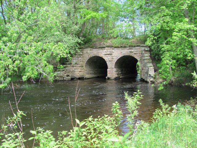
The bridge is an uncommon sight in Michigan, a multi-span stone arch bridge. The bridge contains two semicircular stone arch spans. The arches appear to be in good condition but there is some abutment wingwall deterioration.
The bridge may date to ca. 1870.
This bridge is tagged with the following special condition(s): Unorganized Photos
![]()
Photo Galleries and Videos: Dickerson Creek Railroad Bridge
Bridge Photo-Documentation
Original / Full Size PhotosA collection of overview and detail photos. This gallery offers photos in the highest available resolution and file size in a touch-friendly popup viewer.
Alternatively, Browse Without Using Viewer
![]()
Bridge Photo-Documentation
Mobile Optimized PhotosA collection of overview and detail photos. This gallery features data-friendly, fast-loading photos in a touch-friendly popup viewer.
Alternatively, Browse Without Using Viewer
![]()
Additional Unorganized Photos
Original / Full Size PhotosA supplemental collection of photos that are from additional visit(s) to the bridge and have not been organized or captioned. This gallery offers photos in the highest available resolution and file size in a touch-friendly popup viewer.
Alternatively, Browse Without Using Viewer
![]()
Additional Unorganized Photos
Mobile Optimized PhotosA supplemental collection of photos that are from additional visit(s) to the bridge and have not been organized or captioned. This gallery features data-friendly, fast-loading photos in a touch-friendly popup viewer.
Alternatively, Browse Without Using Viewer
![]()
Maps and Links: Dickerson Creek Railroad Bridge
Coordinates (Latitude, Longitude):
Search For Additional Bridge Listings:
Bridgehunter.com: View listed bridges within 0.5 miles (0.8 kilometers) of this bridge.
Bridgehunter.com: View listed bridges within 10 miles (16 kilometers) of this bridge.
Additional Maps:
Google Streetview (If Available)
GeoHack (Additional Links and Coordinates)
Apple Maps (Via DuckDuckGo Search)
Apple Maps (Apple devices only)
Android: Open Location In Your Map or GPS App
Flickr Gallery (Find Nearby Photos)
Wikimedia Commons (Find Nearby Photos)
Directions Via Sygic For Android
Directions Via Sygic For iOS and Android Dolphin Browser
USGS National Map (United States Only)
Historical USGS Topo Maps (United States Only)
Historic Aerials (United States Only)
CalTopo Maps (United States Only)


