We Recommend:
Bach Steel - Experts at historic truss bridge restoration.
BridgeHunter.com Phase 1 is released to the public! - Visit Now
Old M-35 Bridge

Primary Photographer(s): Nathan Holth
Bridge Documented: October 1, 2012
Rural: Menominee County, Michigan: United States
Not Available or Not Applicable
Not Available
Not Available
Not Available
1 Main Span(s)
Not Applicable

View Information About HSR Ratings
Bridge Documentation
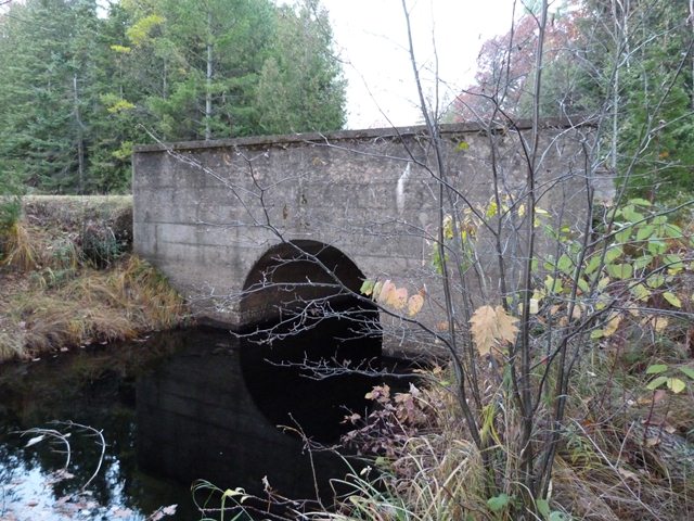
This is a tiny bridge that despite being a very early surviving example of a concrete arch bridge in Michigan with a 1911 construction date, is otherwise unremarkable structurally. However, it has one unusual detail. The bridge has two inscriptions set into the solid concrete parapets. These inscriptions are written in an unusual script that is very odd among bridges. Bridge inscriptions and plaques usually use a plain print font, not a script. The shallow nature of the inscriptions, perhaps some wear and tear over the decades, and the script style inscriptions combine to make them very difficult to read and nearly impossible to photograph in a way that the text is legible given the somewhat low light conditions HistoricBridges.org encountered here. One inscription appears to list the commissioners, and the other inscription appears to list the builders of the bridge, listed as the "bridge crew" which is also somewhat unusual. Bridges often list engineers, contractors, etc, but listing the "bridge crew" which presumably means the actual names of the workers who built the bridge is very unusual.
This bridge is on a road that leads to Bailey County Park, but it was originally the main road prior to the current alignment of M-35 a short distance west of the bridge.
There is apparently another similar bridge on private property a number of miles south of this bridge over Bailey Creek, coordinates 45.20954, -87.52936.
Above: Aerial view of bridge, September 10, 2020. Click for enlargement. Photo Credit: Doug Heim, Angelcopter, LLC
![]()
Photo Galleries and Videos: Old M-35 Bridge
Bridge Photo-Documentation
Original / Full Size PhotosA collection of overview and detail photos. This gallery offers photos in the highest available resolution and file size in a touch-friendly popup viewer.
Alternatively, Browse Without Using Viewer
![]()
Bridge Photo-Documentation
Mobile Optimized PhotosA collection of overview and detail photos. This gallery features data-friendly, fast-loading photos in a touch-friendly popup viewer.
Alternatively, Browse Without Using Viewer
![]()
Maps and Links: Old M-35 Bridge
Coordinates (Latitude, Longitude):
Search For Additional Bridge Listings:
Bridgehunter.com: View listed bridges within 0.5 miles (0.8 kilometers) of this bridge.
Bridgehunter.com: View listed bridges within 10 miles (16 kilometers) of this bridge.
Additional Maps:
Google Streetview (If Available)
GeoHack (Additional Links and Coordinates)
Apple Maps (Via DuckDuckGo Search)
Apple Maps (Apple devices only)
Android: Open Location In Your Map or GPS App
Flickr Gallery (Find Nearby Photos)
Wikimedia Commons (Find Nearby Photos)
Directions Via Sygic For Android
Directions Via Sygic For iOS and Android Dolphin Browser
USGS National Map (United States Only)
Historical USGS Topo Maps (United States Only)
Historic Aerials (United States Only)
CalTopo Maps (United States Only)


