We Recommend:
Bach Steel - Experts at historic truss bridge restoration.
BridgeHunter.com Phase 1 is released to the public! - Visit Now
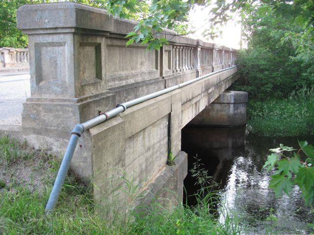
Railroad Street Bridge

Primary Photographer(s): Randy Mulder
Bridge Documented: June 25, 2011
Seney: Schoolcraft County, Michigan: United States
By Builder/Contractor: Unknown and Engineer/Design: Michigan State Highway Department
Not Available or Not Applicable
40.0 Feet (12.2 Meters)
79.7 Feet (24.3 Meters)
30 Feet (9.14 Meters)
2 Main Span(s)
75200032000B010

View Information About HSR Ratings
Bridge Documentation
View Archived National Bridge Inventory Report - Has Additional Details and Evaluation
This bridge is an example of a bridge design built from approximately 1927 to 1932 in relatively large quantities in Michigan.
This bridge has historical significance as part of the M-28 "Seney Stretch", the straight and flat section of highway that parallels the railroad west of here to Shingleton. Originally, the highway ran straight along Railroad St through Seney. However, from 1947 to 1954 MDOT built 10 new bridges from Shingleton to Seney, and because they also jogged M-28 a block north entering Seney, this included a bridge just north of this one. Therefore, this road reverted to local status and this bridge is a remnant of the old highway. The 10 bridges all retain their R4 railings, although covered by Armco guardrail.
The Seney Stretch is usually claimed to be 25 miles long, and sometimes 30, but because the road jogs slightly north into the towns on each end, the actual straight section is probably closer to 23 miles. According to Michigan Highways, before 1949 the highway followed the tracks for several miles more east of Seney, which may explain the 30. This road's straightness and flatness is often given as reasons for M-28 being a very boring drive. Only some of the roads of Michigan's Thumb Area like M-46 might give the road a run for its money.
![]()
Photo Galleries and Videos: Railroad Street Bridge
Bridge Photo-Documentation
Original / Full Size PhotosA collection of overview and detail photos. This gallery offers photos in the highest available resolution and file size in a touch-friendly popup viewer.
Alternatively, Browse Without Using Viewer
![]()
Bridge Photo-Documentation
Mobile Optimized PhotosA collection of overview and detail photos. This gallery features data-friendly, fast-loading photos in a touch-friendly popup viewer.
Alternatively, Browse Without Using Viewer
![]()
Maps and Links: Railroad Street Bridge
Coordinates (Latitude, Longitude):
Search For Additional Bridge Listings:
Bridgehunter.com: View listed bridges within 0.5 miles (0.8 kilometers) of this bridge.
Bridgehunter.com: View listed bridges within 10 miles (16 kilometers) of this bridge.
Additional Maps:
Google Streetview (If Available)
GeoHack (Additional Links and Coordinates)
Apple Maps (Via DuckDuckGo Search)
Apple Maps (Apple devices only)
Android: Open Location In Your Map or GPS App
Flickr Gallery (Find Nearby Photos)
Wikimedia Commons (Find Nearby Photos)
Directions Via Sygic For Android
Directions Via Sygic For iOS and Android Dolphin Browser
USGS National Map (United States Only)
Historical USGS Topo Maps (United States Only)
Historic Aerials (United States Only)
CalTopo Maps (United States Only)

