



View Information About HSR Ratings
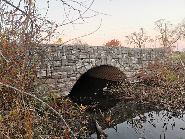
This page covers two identical bridges on a circle drive in this small park. The map links point to the southern bridge, the northern one is directly opposite in the circle at 43.253927, -86.236134. These bridges have the appearance of stone arch bridges but are like fancy corrugated steel culverts. The type was common in the 1930s, often as Depression-era relief programs in parks. The bridges were easy and cost-effective to build yet had an attractive appearance for parks.
The two small stone-faced corrugated metal arch bridges in Richards Park are surviving features of a much larger Depression-era highway beautification and park development associated with the Muskegon Causeway. Although their rustic stone appearance is reminiscent of bridges constructed under programs such as the Works Progress Administration (WPA), available historical documentation instead associates development of this area primarily with federal New Deal highway funding, the Michigan State Highway Department, Muskegon County, and a broader civic effort to create an impressive landscaped northern entrance to Muskegon.
Richards Charter Park, historically known as Richards Park and also called Boom Park, is today an unusually small and rustic 7.5-acre park at the north end of Ottawa Street in Muskegon. Its most distinctive historic feature is a circular drive surrounding a small pond or lagoon. Two small bridges carry the drive across waterways associated with the lagoon. These structures consist of corrugated structural metal arches concealed behind substantial rustic stone masonry facing.
The seemingly unusual arrangement of a circular roadway, lagoon, ornamental stonework, and bridges makes considerably more sense when viewed as a surviving fragment of a much larger early twentieth-century landscape development.
The origins of the project date to 1924, when Louis Lunsford, chairman of the Muskegon Chamber of Commerce, proposed transforming approximately 55 acres of marshland between Muskegon and North Muskegon into an impressive landscaped entrance to the city and a memorial to local World War I veterans.
At the time, the marsh contained considerable debris remaining from Muskegon's lumber industry. Lunsford envisioned transforming this unattractive area into a designed landscape containing lagoons, lawns, trees, curving drives and paths, together with monuments commemorating Muskegon's veterans.
The ambitious proposal was initially regarded by some as impractical because of its considerable cost. It eventually gained broader support, particularly after the Michigan State Highway Department became involved. The Highway Department agreed to construct a divided highway and bridges across the wetlands, provided that local interests paid the additional cost of decorative improvements beyond ordinary highway construction.
Construction consequently began before the principal New Deal programs of the Depression existed. This is important when interpreting the surviving structures in and around Richards Park. The Muskegon Causeway was not originally conceived as a WPA project. Rather, it was a locally conceived civic and highway improvement begun during the prosperous 1920s that was subsequently expanded and completed during the Depression with the assistance of federal New Deal funding.
Work on the transportation components of the project was underway by the late 1920s. Construction of the approximately 40-foot steel beam-stringer northbound causeway bridge began in 1928.
The nearby Ottawa Street Bridge also belongs to this early phase of development. Current bridge records identify the Ottawa Street Bridge as having been constructed in 1929 by the Michigan State Highway Department. The bridge is a concrete-encased steel multi-beam stringer structure with decorative concrete balustrade railings characteristic of Michigan State Highway Department bridge design of the late 1920s and early 1930s.
Some later historical accounts, including the West Michigan Pike historic context, state that the Ottawa Street Bridge was completed in 1934. However, current bridge records give a construction date of 1929, and the physical design and detailing of the structure are consistent with the earlier date. Recent historic-preservation documentation concerning the bridge likewise places its construction within the 1926–1932 period.
The 1934 date appearing in the historical narrative therefore appears to be associated with completion of the larger Muskegon Causeway and park development rather than representing the actual construction date of the Ottawa Street Bridge.
The companion southbound causeway bridge was completed in 1931.
The onset of the Great Depression did not end the ambitious Muskegon project. Instead, the availability of federal highway funding allowed work to continue and ultimately helped make the complete landscaped development possible.
Federal funds provided through the National Recovery Highway Act were used to realign US-31 and incorporate the highway into the proposed development, which became known as the Muskegon Causeway.
The Michigan State Highway Department participated extensively in the project, while Muskegon County paid additional costs associated with ornamental improvements beyond those necessary for conventional highway construction.
The resulting causeway development represented a substantial public works undertaking. Historical documentation places the total cost of the causeway and park improvements at approximately $750,000. Approximately $300,000 was reportedly devoted to four major bridges, while approximately $100,000 was spent on development of the lawns and lagoons.
Ottawa Street, which had carried the original route of the West Michigan Pike, was widened as part of the improvements to create an approximately 40-foot-wide entrance to the causeway.
The project therefore served several purposes simultaneously. It improved highway transportation through Muskegon, created a landscaped connection between US-31, Scenic Drive and Muskegon State Park, established an impressive northern gateway for automobile tourists entering Muskegon, and created a major public memorial to local veterans.
Landscape architecture was an integral component of the Muskegon Causeway project rather than merely decoration added after completion of the highway.
Landscape architect Willard S. Gebhart, a native of Hart, Michigan, who had established a practice in Washington, D.C., was hired to oversee development of the park landscape and creation of its lawns and lagoons.
A special federal landscaping appropriation also provided funding for the planting of hundreds of trees along the lagoons.
The completed development consequently combined highway engineering with the principles of the early twentieth-century highway beautification and City Beautiful movements. Motorists approaching Muskegon encountered a deliberately designed landscape of water, vegetation, curving roads, ornamental masonry, bridges and memorial features rather than a purely utilitarian highway causeway.
Richards Park formed part of this larger landscape.
Historical documentation specifically identifies Richards Park as containing surviving remnants of the highway beautification project, including historic bridges, stone walls, lagoons and plantings. The Michigan State Historic Preservation Office's West Michigan Pike study describes both the Ottawa Street Bridge and Richards Park as artifacts associated with the early improvements to US-31 in Muskegon.
The two small bridges within Richards Park are particularly notable surviving elements of this landscape. Each employs a corrugated metal arch as its structural component while presenting substantial stone-faced elevations designed to harmonize with the rustic park environment.
The combination of an economical corrugated metal structural arch with decorative stone masonry was particularly appropriate for a scenic highway or park development. The metal structure provided an efficient means of carrying the roadway across the waterways while the masonry exterior gave the crossings the appearance of traditional stone arch bridges.
Historical documentation of the West Michigan Pike project specifically mentions decorative stonework and bridges within Richards Park that remained visible when the historic resource survey was completed.
The exact construction date of the two small Richards Park bridges has not yet been established through original bridge plans, contracts or construction records.
However, their location, physical character and documented association with the Muskegon Causeway landscape provide strong evidence that they were constructed as components of the extensive park and highway beautification program undertaken from the late 1920s through 1934.
They should not presently be identified specifically as WPA bridges. The overall development began several years before creation of the WPA, and historical sources instead document Michigan State Highway Department involvement and later federal New Deal assistance through highway and landscaping appropriations.
The park bridges may have been constructed during the later Depression-era landscaping phase of the project, possibly circa 1933–1934, but an exact construction date should be considered unconfirmed until original construction documentation is located.
Veterans Memorial Park occupied the prominent landscaped portion of the causeway between the parallel highway bridges.
Development of the memorial itself reportedly required approximately three years. Its centerpiece included a fountain and reflecting pool surrounded by stone walls. Limestone pillars carried bronze plaques listing the names of 104 Muskegon servicemen who died during the World War I period of 1917–1918.
The completed memorial was dedicated on Armistice Day, November 11, 1934.
At the dedication ceremony, René Weiller, Chicago Consul of the Republic of France, participated in planting some of 200 fleur-de-lis bulbs presented as a gift from France.
The November 1934 dedication effectively marked the culmination of a civic improvement effort whose origins stretched back a decade to Lunsford's original 1924 proposal.
1924 – Original Park Proposal:
Muskegon Chamber of Commerce chairman Louis Lunsford proposes transforming approximately 55 acres of marsh and lumber-industry debris between Muskegon and North Muskegon into a landscaped park and memorial to Muskegon's World War I dead. The proposed development includes lagoons, curving drives and paths, landscaping and memorial features.
Late 1920s – Michigan State Highway Department Involvement:
The Michigan State Highway Department agrees to construct a divided highway and bridges through the area, provided that local interests finance the additional expense associated with decorative improvements beyond conventional highway construction.
1928 – Causeway Bridge Construction Begins:
Construction begins on the approximately 40-foot-wide steel beam-stringer northbound causeway bridge.
1929 – Ottawa Street Bridge:
The Michigan State Highway Department constructs the Ottawa Street Bridge over the South Branch of the Muskegon River. The concrete-encased steel stringer bridge provides access toward what became Richards Park and forms part of the developing transportation system associated with the causeway project. Its decorative concrete balustrade railing and structural design are characteristic of MSHD bridge construction of this period.
1931 – Southbound Causeway Bridge:
The companion southbound causeway bridge is completed.
1930s – Depression-Era Expansion:
Work on the broader development continues despite the Great Depression. Federal New Deal highway funding subsequently becomes available, allowing the ambitious project to proceed.
1933–1934 – New Deal Highway and Landscape Improvements:
National Recovery Highway Act funding assists with realignment of US-31 and development of the Muskegon Causeway. Landscape architect Willard S. Gebhart oversees development of lawns and lagoons, while a special federal landscaping appropriation funds the planting of hundreds of trees. Decorative stonework, bridges and other park features are constructed as components of the landscaped highway environment. The two surviving stone-faced corrugated metal arch bridges in Richards Park likely date from this general phase of the development, although their exact construction date has not yet been documented.
1934 – Completion of the Larger Causeway Development:
The broader Muskegon Causeway, park and highway beautification project reaches completion. Ottawa Street is widened to provide an approximately 40-foot-wide entrance to the causeway. Some later historical sources consequently associate 1934 with the Ottawa Street Bridge, although bridge records identify that individual structure as having been built in 1929.
November 11, 1934 – Veterans Memorial Park Dedicated:
The completed Veterans Memorial Park is formally dedicated on Armistice Day, marking the culmination of approximately a decade of planning and construction.
Richards Park subsequently underwent substantial changes that obscured portions of the original designed landscape.
A sewage treatment facility eventually occupied part of the park property. The abandoned facility was demolished by the City of Muskegon around 2008, after which portions of the site were returned to vegetation and natural habitat.
These alterations help explain why Richards Park today appears isolated and why the original purpose of its circular roadway, lagoon, ornamental stonework and bridges is not immediately apparent.
Nevertheless, the surviving bridges, stone walls, lagoon, plantings and roadway configuration provide tangible remnants of the much more ambitious Muskegon Causeway development.
Rather than simply being two minor crossings in an obscure municipal park, the Richards Park bridges appear to survive from an important period in Muskegon's transportation and civic history. Together with the 1929 Ottawa Street Bridge and Veterans Memorial Park, they represent surviving components of a coordinated effort to combine highway engineering, civic beautification, landscape architecture and tourism development.
The development is also an interesting example of a major public improvement whose history spans both sides of the beginning of the Great Depression. Conceived in 1924 and under construction by the late 1920s, the Muskegon Causeway project was subsequently carried forward with Depression-era federal assistance and ultimately completed and dedicated in 1934.
Historical information concerning the Muskegon Causeway, Richards Park, Veterans Memorial Park and associated highway beautification is documented in the Michigan State Historic Preservation Office's historic context study of the West Michigan Pike. The study specifically identifies Richards Park as retaining historic bridges, stone walls, lagoons and plantings associated with the highway beautification project.
Additional information concerning Richards Charter Park and the Ottawa Street Bridge is available from the City of Muskegon and Michigan Department of Transportation historic-preservation documentation. Current bridge records identify the Ottawa Street Bridge as constructed in 1929, while recent Section 106 documentation places its construction within the 1926–1932 period.


Coordinates (Latitude, Longitude):
Search For Additional Bridge Listings:
Bridgehunter.com: View listed bridges within 0.5 miles (0.8 kilometers) of this bridge.
Bridgehunter.com: View listed bridges within 10 miles (16 kilometers) of this bridge.
Additional Maps:
Google Streetview (If Available)
GeoHack (Additional Links and Coordinates)
Apple Maps (Via DuckDuckGo Search)
Apple Maps (Apple devices only)
Android: Open Location In Your Map or GPS App
Flickr Gallery (Find Nearby Photos)
Wikimedia Commons (Find Nearby Photos)
Directions Via Sygic For Android
Directions Via Sygic For iOS and Android Dolphin Browser
USGS National Map (United States Only)
Historical USGS Topo Maps (United States Only)
Historic Aerials (United States Only)
CalTopo Maps (United States Only)

© Copyright 2003-2026, HistoricBridges.org. All Rights Reserved. Disclaimer: HistoricBridges.org is a volunteer group of private citizens. HistoricBridges.org is NOT a government agency, does not represent or work with any governmental agencies, nor is it in any way associated with any government agency or any non-profit organization. While we strive for accuracy in our factual content, HistoricBridges.org offers no guarantee of accuracy. Information is provided "as is" without warranty of any kind, either expressed or implied. Information could include technical inaccuracies or errors of omission. Opinions and commentary are the opinions of the respective HistoricBridges.org member who made them and do not necessarily represent the views of anyone else, including any outside photographers whose images may appear on the page in which the commentary appears. HistoricBridges.org does not bear any responsibility for any consequences resulting from the use of this or any other HistoricBridges.org information. Owners and users of bridges have the responsibility of correctly following all applicable laws, rules, and regulations, regardless of any HistoricBridges.org information.
