

View Information About HSR Ratings
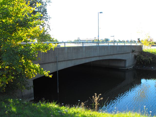
This bridge is a later example of a concrete rigid-frame bridge in Michigan. It is also an early example of a bridge with concrete and pole combination guardrails. Michigan State Highway Department/MDOT would itself adopt a combination concrete/pole guardrail design, but it would be different than the design seen here. The bridge is mainly only considered historic because it falls within the period of significance for the Belle Isle Historic District and as such is a contributing structure to the district.
Information and Findings From Michigan Historic Bridge InventoryNarrative Description This concrete rigid-frame bridge, which is oriented on a north-south axis, currently carries one-way traffic. It is located on Belle Isle, just south of the bridge connecting the island with the mainland. The Casino Way Bridge has a simple railing, consisting of a solid concrete base topped with a single metal rail, edging the sidewalks along both sides of the roadway. The rail terminates in the streamlined curve. The end is missing on the southeast end; the northwest end is flattened. In general, though, the bridge displays very good design integrity. A metal-arch structure with a lattice railing originally served this crossing. The bridge was widened in 1927, and replaced altogether in 1946, according to plans at the Detroit City Engineering Department. The 1946 project also included some modifications to the road's route, resulting in the new bridges location slightly to the east of the earlier structure. Plans for the new bridge, which were prepared by the City Engineering Office, are dated May 1946. On 20 August 1946, the city of Detroit closed bidding for the construction of three bridges on Belle Isle, including the Casino Way Bridge. This bridge has just reached the fifty-year line typically drawn for National Register eligibility. It is within the Belle Isle National Register district, and should be considered a contributing structure in that district. |
![]()
![]()
![]()
Coordinates (Latitude, Longitude):
Search For Additional Bridge Listings:
Bridgehunter.com: View listed bridges within 0.5 miles (0.8 kilometers) of this bridge.
Bridgehunter.com: View listed bridges within 10 miles (16 kilometers) of this bridge.
Additional Maps:
Google Streetview (If Available)
GeoHack (Additional Links and Coordinates)
Apple Maps (Via DuckDuckGo Search)
Apple Maps (Apple devices only)
Android: Open Location In Your Map or GPS App
Flickr Gallery (Find Nearby Photos)
Wikimedia Commons (Find Nearby Photos)
Directions Via Sygic For Android
Directions Via Sygic For iOS and Android Dolphin Browser
USGS National Map (United States Only)
Historical USGS Topo Maps (United States Only)
Historic Aerials (United States Only)
CalTopo Maps (United States Only)

© Copyright 2003-2026, HistoricBridges.org. All Rights Reserved. Disclaimer: HistoricBridges.org is a volunteer group of private citizens. HistoricBridges.org is NOT a government agency, does not represent or work with any governmental agencies, nor is it in any way associated with any government agency or any non-profit organization. While we strive for accuracy in our factual content, HistoricBridges.org offers no guarantee of accuracy. Information is provided "as is" without warranty of any kind, either expressed or implied. Information could include technical inaccuracies or errors of omission. Opinions and commentary are the opinions of the respective HistoricBridges.org member who made them and do not necessarily represent the views of anyone else, including any outside photographers whose images may appear on the page in which the commentary appears. HistoricBridges.org does not bear any responsibility for any consequences resulting from the use of this or any other HistoricBridges.org information. Owners and users of bridges have the responsibility of correctly following all applicable laws, rules, and regulations, regardless of any HistoricBridges.org information.
![]()