We Recommend:
Bach Steel - Experts at historic truss bridge restoration.
BridgeHunter.com Phase 1 is released to the public! - Visit Now
Old US-41 Peshekee River Bridge
Trunk Line Bridge Number 1

Primary Photographer(s): Nathan Holth
Bridge Documented: October 1, 2012 and November 13, 2021
Rural: Marquette County, Michigan: United States
1914 By Builder/Contractor: Powell and Mitchell of Marquette, Michigan and Engineer/Design: Michigan State Highway Department
Not Available or Not Applicable
40.0 Feet (12.2 Meters)
240.0 Feet (73.2 Meters)
15 Feet (4.57 Meters)
6 Main Span(s)
Not Applicable

View Information About HSR Ratings
Bridge Documentation
View Archived National Bridge Inventory Report - Has Additional Details and Evaluation
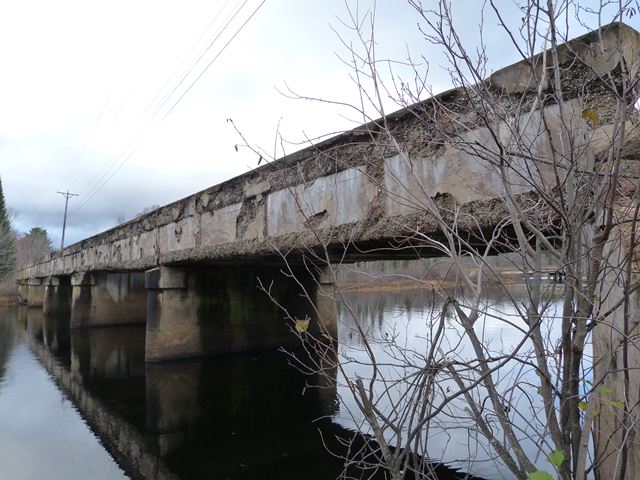
How many states can claim in the 21st Century to still have the first state highway bridge ever built in the state still standing? Given that such a bridge would be very old, and given that state highways tend to have higher traffic volumes, it is unlikely that such a bridge would survive in a particular state. However, Michigan can in fact claim to have the first bridge ever built for Michigan's state trunk line system still standing! The primary reason that this bridge survives today is likely because it did not serve as a trunk line bridge for very long. By 1930, the bridge was replaced with a steel stringer bridge on a new and improved alignment for the trunk line. As such, the concrete girder bridge was abandoned, and never needed to be demolished and replaced. If it had continued to serve trunk line traffic it would surely have been replaced, if for no other reason than that the bridge would end up being too narrow for state trunk line traffic. In fact, even the 1930 bridge has not survived, since it was replaced in 1995.
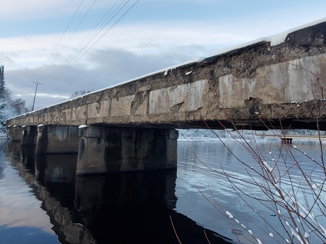
As such, the bridge is highly significant since it marks the beginning of bridge construction by Michigan's state highway agency, then called the Michigan State Highway Department and today called Michigan Department of Transportation. The bridge is also structurally significant. It is the longest straight chord concrete through girder bridge in Michigan. It would be the longest concrete girder of any type, except that the Mottville Bridge, a curved chord through girder, has it beat. However, no other concrete girder in Michigan has more spans than the Peshekee River Bridge, which has six spans. It is unusual to see the concrete through girder type, which was common for short crossings, used in a multi-span format for a longer river crossing. Finally, the bridge appears to be the oldest concrete girder in Michigan. Its age may be why the bridge stylistically does not follow the state standard plans for straight chord through girder bridges, which generally date from 1916 onward. The Peshekee River Bridge is far more simple in appearance than the already simple appearance of those state standard girders. The only architectural detailing on the bridge is simple inset rectangles on the outside of the girders. The bridge also does not have any bronze plaques that are a trademark of most state trunk line bridges. Instead, a simple casting is in the girders reading "State Trunk Line Bridge 1914".
The bridge today continues to sit abandoned, but available to pedestrians within Van Riper State Park. As such, the bridge is today owned by the DNR. Despite the fact that the bridge has enjoyed a life away from traffic and corrosive winter deicing salts, the bridge is nevertheless severely deteriorated. Widespread and severe spalling is present on the bridge. The deck's deterioration is not helped by the fact that dirt has built up on the deck and now grass grows on the bridge. All of this traps moisture on the deck which causes deterioration. Standing water was observed on the bridge deck during the field visit because the water has no way to drain off the deck. The widespread deterioration of the bridge has led to a weakening of the concrete girders. If viewed from the right angle, a slight sagging of each girder span in between piers can be seen.
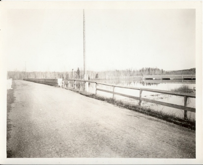
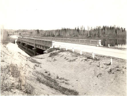
Thank you to Frank Paris for scanning the historical photos on this page, which are held by the Marquette County Road Commission.
Above: A post-1930 historical photo of Trunk Line Bridge #1, with the 1930 bridge visible in the background.
A historical photo showing the 1930 replacement bridge and alignment which ended Trunk Line Bridge #1's service as a Trunk Line Bridge.
Information and Findings From Michigan Historic Bridge InventoryNarrative Description This multiple-span concrete bridge is located in the Champion Beach County Park, about five miles east of the village of |
This bridge is tagged with the following special condition(s): Unorganized Photos
![]()
Photo Galleries and Videos: Old US-41 Peshekee River Bridge
Bridge Photo-Documentation
Original / Full Size PhotosA collection of overview and detail photos. This gallery offers photos in the highest available resolution and file size in a touch-friendly popup viewer.
Alternatively, Browse Without Using Viewer
![]()
Bridge Photo-Documentation
Mobile Optimized PhotosA collection of overview and detail photos. This gallery features data-friendly, fast-loading photos in a touch-friendly popup viewer.
Alternatively, Browse Without Using Viewer
![]()
Additional Unorganized Photos
Original / Full Size PhotosA supplemental collection of photos that are from additional visit(s) to the bridge and have not been organized or captioned. This gallery offers photos in the highest available resolution and file size in a touch-friendly popup viewer.
Alternatively, Browse Without Using Viewer
![]()
Additional Unorganized Photos
Mobile Optimized PhotosA supplemental collection of photos that are from additional visit(s) to the bridge and have not been organized or captioned. This gallery features data-friendly, fast-loading photos in a touch-friendly popup viewer.
Alternatively, Browse Without Using Viewer
![]()
Maps and Links: Old US-41 Peshekee River Bridge
Coordinates (Latitude, Longitude):
Search For Additional Bridge Listings:
Bridgehunter.com: View listed bridges within 0.5 miles (0.8 kilometers) of this bridge.
Bridgehunter.com: View listed bridges within 10 miles (16 kilometers) of this bridge.
Additional Maps:
Google Streetview (If Available)
GeoHack (Additional Links and Coordinates)
Apple Maps (Via DuckDuckGo Search)
Apple Maps (Apple devices only)
Android: Open Location In Your Map or GPS App
Flickr Gallery (Find Nearby Photos)
Wikimedia Commons (Find Nearby Photos)
Directions Via Sygic For Android
Directions Via Sygic For iOS and Android Dolphin Browser
USGS National Map (United States Only)
Historical USGS Topo Maps (United States Only)
Historic Aerials (United States Only)
CalTopo Maps (United States Only)


