We Recommend:
Bach Steel - Experts at historic truss bridge restoration.
BridgeHunter.com Phase 1 is released to the public! - Visit Now
West Grand Boulevard Railroad Overpass

Primary Photographer(s): Nathan Holth and Rick McOmber
Bridge Documented: July 1, 2007 and May 29, 2022
Railroad (Norfolk Southern, Former Michigan Central Railway) Over West Grand Boulevard
Detroit: Wayne County, Michigan: United States
1896 By Builder/Contractor: Thomas J. Kennedy and Engineer/Design: W. H. Ashwell and Company
Not Available or Not Applicable
50.0 Feet (15.2 Meters)
55.8 Feet (17 Meters)
Not Available
1 Main Span(s)
824180800272X01

View Information About HSR Ratings
Bridge Documentation
View Archived National Bridge Inventory Report - Has Additional Details and Evaluation
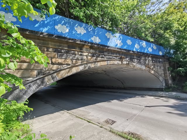
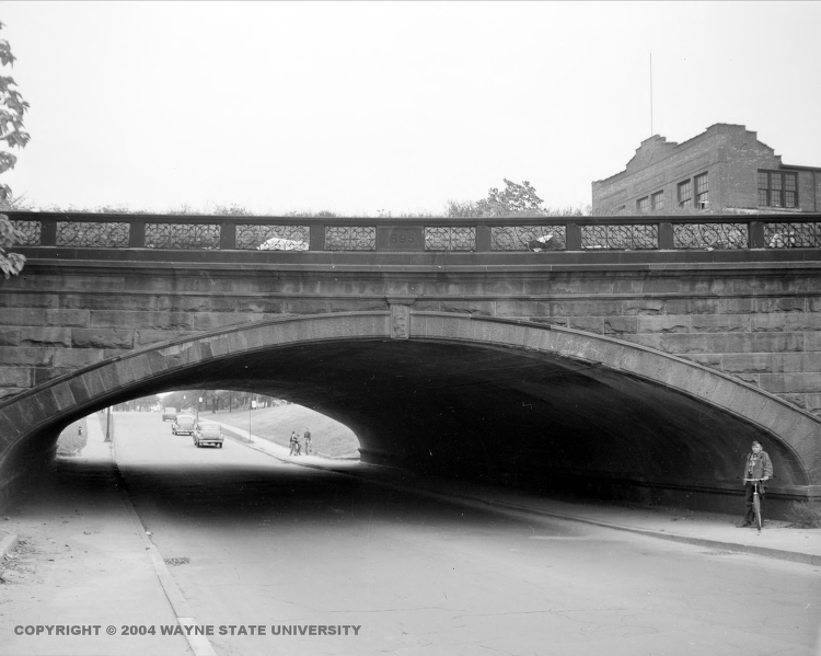
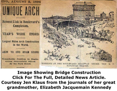
This bridge is a great way to make sure truck traffic does not travel on residential roads, as this bridge has extremely low vertical clearance. The bridge features a beautiful stone texturing which makes the bridge look like a stone arch to casual viewers. The bridge features an elliptical arch shape that spans the two-lane roadway and both sidewalks. An ugly concrete barrier has been added to the structure. Detroit has many railroad over highway grade separations, but this bridge stands out for its arch design. The bridge is one of the rarest and most significant historic bridges in Michigan. Constructed in 1895, it is one of the oldest... if not the oldest... concrete arch bridges in Michigan, and is among the oldest surviving concrete bridges in North America. It is also the only known example of a concrete arch bridge with Melan type reinforcing in Michigan. Melan reinforcing was essentially solid ribs of arched steel that were encased in concrete. This is quite different from the use of reinforcing rods, or rebar, as found in most examples of reinforced concrete. When completed, the bridge was described as the largest Melan arch bridge in the world. A historical article described the bridge in detail. The bridge's Melan reinforcing consists of 41 built-up riveted steel beams. Each built-up beam is composed of two paired angles connected by lattice. The space between these beams was filled with 1800 cubic yards of concrete. The face of the arch was covered with stone for aesthetic reasons, a practice common in the earlier years of concrete usage in bridge construction, as engineers had not yet figured out how to use concrete itself to produce aesthetic qualities, and people enjoyed the traditional appearance of a stone arch bridge as well. The stone on this bridge was described as Berea stone and Amhurst buff stone.
Below historical photo (note original ornate railing with 1895 date stone) from WSU Virtual Motor City Collection (Detroit News).

This bridge is tagged with the following special condition(s): Melan and Unorganized Photos
![]()
Photo Galleries and Videos: West Grand Boulevard Railroad Overpass
Bridge Photo-Documentation
A collection of overview and detail photos. This photo gallery contains a combination of Original Size photos and Mobile Optimized photos in a touch-friendly popup viewer.Alternatively, Browse Without Using Viewer
![]()
Additional Unorganized Photos
Original / Full Size PhotosA supplemental collection of photos that are from additional visit(s) to the bridge and have not been organized or captioned. This gallery offers photos in the highest available resolution and file size in a touch-friendly popup viewer.
Alternatively, Browse Without Using Viewer
![]()
Additional Unorganized Photos
Mobile Optimized PhotosA supplemental collection of photos that are from additional visit(s) to the bridge and have not been organized or captioned. This gallery features data-friendly, fast-loading photos in a touch-friendly popup viewer.
Alternatively, Browse Without Using Viewer
![]()
Maps and Links: West Grand Boulevard Railroad Overpass
Coordinates (Latitude, Longitude):
Search For Additional Bridge Listings:
Bridgehunter.com: View listed bridges within 0.5 miles (0.8 kilometers) of this bridge.
Bridgehunter.com: View listed bridges within 10 miles (16 kilometers) of this bridge.
Additional Maps:
Google Streetview (If Available)
GeoHack (Additional Links and Coordinates)
Apple Maps (Via DuckDuckGo Search)
Apple Maps (Apple devices only)
Android: Open Location In Your Map or GPS App
Flickr Gallery (Find Nearby Photos)
Wikimedia Commons (Find Nearby Photos)
Directions Via Sygic For Android
Directions Via Sygic For iOS and Android Dolphin Browser
USGS National Map (United States Only)
Historical USGS Topo Maps (United States Only)
Historic Aerials (United States Only)
CalTopo Maps (United States Only)


