

View Information About HSR Ratings

Above: Courtesy of the Digital Bridges collection, a through truss variation of this patented bridge design marketed by the Wrought Iron Bridge Company appearing in a period pamphlet distributed by the company. Click the image for a larger version with a description.
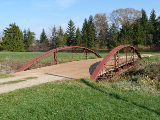
This bridge is the only remaining 1870s bowstring truss bridge in the entire state of Michigan! Bowstring truss bridges were the metal bridge of choice during the 1870s, a very short period of time, because by the 1880s the pin-connected Pratt truss and other variants became the standard. Surviving examples are extremely rare today, and because they usually predate 1880, are among the oldest surviving metal bridges in the country. The bridge is today distinguished as one of the two oldest and most important metal bridges in Michigan.
Bowstring truss bridges are very easy to associate with a builder because during this time a lot of experimentation was occurring with bridges, both in terms of overall design but also down to the forms of structural iron used to compose the trusses. Builders frequently patented and defended those patented designs aggressively. This bridge is a product of the Wrought Iron Bridge Company of Canton Ohio, an assessment made by an observation of the design of the bridge. This extremely prolific company produced a variety of truss bridges in the late 19th Century. This bowstring bridge is an excellent surviving example of one of the designs that this bridge company offered, which was marketed as a "plate and channel arch bridge." Although composing a top chord using a plate and channel (back-to-back channels with riveted cover plate) top chord was a method that actually became the most common way to build most late 19th century truss bridges of any kind by any company, very few of the bowstring bridges built by the Wrought Iron Bridge Company that remain today exhibit the plate and channel top chord. Most surviving examples instead display the Keystone column top chord. Keystone columns themselves are rare, and indeed the one place they are most frequently found is on the Wrought Iron Bridge Company bowstrings.
In the Wrought Iron Bridge Company's 1880s illustrated pamphlet, the plate and channel bowstring appears in the pamphlet with some interesting comments. As mentioned earlier, new bridge ideas were frequently being patented and aggressively defended by the patentee. The pamphlet description of the plate and channel bowstring remarks that "The Lattice Posts, whether made of Star, Angles or Tees, are covered by patents owned exclusively by this Company, and all other makers or users will be held liable for damages." Indeed, the Wrought Iron Bridge Company did use built-up vertical members with lattice on this and many of their bowstring truss bridges, and even their Pratt pony truss bridges which became popular in the early 1880s. The Townline Brook Bridge's lattice vertical members are composed using the "Tee's" which are T-shaped rolled beams. The "Stars" that the aforementioned quote describes are in fact also present on the Townline Brook Bridge, but not with the lattice, instead appearing on their own, acting as vertical members on all panel points that do not contain the latticed members. These aptly named beams/rods, are truly star-shaped and are quite attractive. Star-shaped beams/rods were only used for a short time, mostly in the same 1870s period that the bowstring truss bridges were being built. Later, more common structural steel elements like rods and angles became the preferred design.
The Townline Brook Bridge is as a result an example of a rare structure type and a good representative example of the work that the Wrought Iron Bridge Company. The bridge's original location is unknown, but up until 1967 it was located in Bennett Park in Charlotte. In 1967, it was relocated onto a private property to serve as a crossing to access a home. In this location, away from heavy traffic and salt, the bridge has not deteriorated and appears to be in excellent condition. In addition, despite its age and apparent relocation two times, the bridge has no notable alterations. The only structural issues observed on the bridge was some evidence of old collision damage that bent a couple verticals. The owner of the bridge commented that they had the bridge redecked with new wood planks a few years ago, and these appear to be holding up very well. The only work HistoricBridges.org would recommend for the bridge at this time would be to remove the dirt which appears to have built up around the ends of the truss. Because the ends of the bridge are buried in this dirt, moisture can build up there and could cause deterioration.
Information and Findings From Michigan Historic Bridge InventoryNarrative Description There is no
information about the history of the Residential Drive Bridge in county
or local records. According to its owner, Zygmunt Brzycki, the bridge
was moved to this site from Bennett Park in Charlotte in 1968. A
photograph in a booklet prepared for Charlotte's centennial in 1963
appears to show the bridge in the park. The bridge was probably
originally erected in another location in the late nineteenth century,
then salvaged by the city for park use when it became inadequate to
handle farm machinery and car traffic in the twentieth century. Statement of Significance This bowstring truss bridge is eligible for the National Register as an excellent example of the bowstring pony truss, a once common bridge type that is now extremely rare. |
![]()
![]()
![]()

![]()
This map shows the park in which the bridge was located until 1967. The map is shown for reference purposes only. The bridge today is located on private property. The exact location of the bridge is not being displayed online at this time out of respect for the owner. Please contact HistoricBridges.org using the contact link at the bottom of this page if you have any questions.
Coordinates (Latitude, Longitude):
Search For Additional Bridge Listings:
Bridgehunter.com: View listed bridges within 0.5 miles (0.8 kilometers) of this bridge.
Bridgehunter.com: View listed bridges within 10 miles (16 kilometers) of this bridge.
Additional Maps:
Google Streetview (If Available)
GeoHack (Additional Links and Coordinates)
Apple Maps (Via DuckDuckGo Search)
Apple Maps (Apple devices only)
Android: Open Location In Your Map or GPS App
Flickr Gallery (Find Nearby Photos)
Wikimedia Commons (Find Nearby Photos)
Directions Via Sygic For Android
Directions Via Sygic For iOS and Android Dolphin Browser
USGS National Map (United States Only)
Historical USGS Topo Maps (United States Only)
Historic Aerials (United States Only)
CalTopo Maps (United States Only)

© Copyright 2003-2025, HistoricBridges.org. All Rights Reserved. Disclaimer: HistoricBridges.org is a volunteer group of private citizens. HistoricBridges.org is NOT a government agency, does not represent or work with any governmental agencies, nor is it in any way associated with any government agency or any non-profit organization. While we strive for accuracy in our factual content, HistoricBridges.org offers no guarantee of accuracy. Information is provided "as is" without warranty of any kind, either expressed or implied. Information could include technical inaccuracies or errors of omission. Opinions and commentary are the opinions of the respective HistoricBridges.org member who made them and do not necessarily represent the views of anyone else, including any outside photographers whose images may appear on the page in which the commentary appears. HistoricBridges.org does not bear any responsibility for any consequences resulting from the use of this or any other HistoricBridges.org information. Owners and users of bridges have the responsibility of correctly following all applicable laws, rules, and regulations, regardless of any HistoricBridges.org information.
![]()