

View Information About HSR Ratings
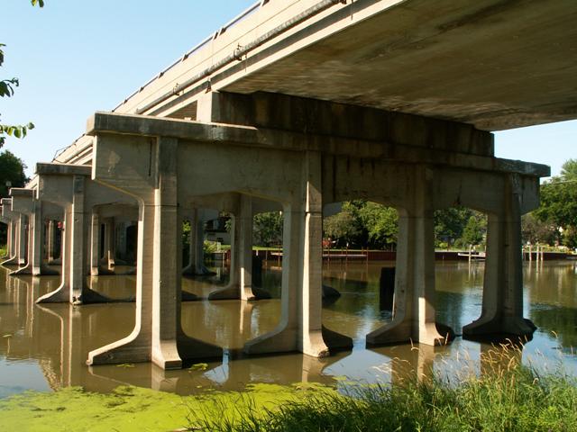
It is rare that a bridge would appear on the website on the basis of its substructure only. The superstructure is an ugly modern slab of concrete (pre-stressed box beams), and is a disgrace to modern engineering and although it can be seen in the photos, is not a part of this webpage any more than the trees in the background! It replaced the original superstructure in 1972 However, this ugly slab was placed on top of the piers of the bridge it replaced, which are a part of this website, as they deserve to be. These piers are quite complex in design, and are noteworthy and historic in their own right, and provide a reminder to the beautiful bridge that was once here. They likely once held a mighty 1930s structure such as that found in Ionia County on Cleveland Avenue. In terms of the route it follows, Bridgeview Street is really Jefferson Avenue in disguise, and other bridges found on the Jefferson Avenue corridor such as this bridge date to the 1930s. Before expressways like I-94 came to be, Jefferson Avenue was likely more of a through route, and would have been much busier. In addition, the Selfridge Air Force Base cut off Jefferson Avenue, further reducing the value as a through road that it once enjoyed. The wide piers that the narrower two-lane modern superstructure sits on suggest the bridge preceding the current slab had perhaps four lanes, and thus was designed to carry more traffic. This crossing is elevated to facilitate the passage of boats. Old North River Road runs under this bridge on the north side. An interesting design consideration, decorative concrete panels are present on the pier next to this road to act as guardrails.
In 2009, the entire bridge, both original substructure and modern substructure was demolished and replaced with an ugly modern bridge. What is ironic is at the time of demolition the "modern" superstructure was just as deteriorated as the much older substructure, evidence of the higher quality of bridges built in the 1930s versus those built in the 1970s.
![]()
![]()
This historic bridge has been demolished. This map is shown for reference purposes only.
Coordinates (Latitude, Longitude):
Search For Additional Bridge Listings:
Bridgehunter.com: View listed bridges within 0.5 miles (0.8 kilometers) of this bridge.
Bridgehunter.com: View listed bridges within 10 miles (16 kilometers) of this bridge.
Additional Maps:
Google Streetview (If Available)
GeoHack (Additional Links and Coordinates)
Apple Maps (Via DuckDuckGo Search)
Apple Maps (Apple devices only)
Android: Open Location In Your Map or GPS App
Flickr Gallery (Find Nearby Photos)
Wikimedia Commons (Find Nearby Photos)
Directions Via Sygic For Android
Directions Via Sygic For iOS and Android Dolphin Browser
USGS National Map (United States Only)
Historical USGS Topo Maps (United States Only)
Historic Aerials (United States Only)
CalTopo Maps (United States Only)

© Copyright 2003-2025, HistoricBridges.org. All Rights Reserved. Disclaimer: HistoricBridges.org is a volunteer group of private citizens. HistoricBridges.org is NOT a government agency, does not represent or work with any governmental agencies, nor is it in any way associated with any government agency or any non-profit organization. While we strive for accuracy in our factual content, HistoricBridges.org offers no guarantee of accuracy. Information is provided "as is" without warranty of any kind, either expressed or implied. Information could include technical inaccuracies or errors of omission. Opinions and commentary are the opinions of the respective HistoricBridges.org member who made them and do not necessarily represent the views of anyone else, including any outside photographers whose images may appear on the page in which the commentary appears. HistoricBridges.org does not bear any responsibility for any consequences resulting from the use of this or any other HistoricBridges.org information. Owners and users of bridges have the responsibility of correctly following all applicable laws, rules, and regulations, regardless of any HistoricBridges.org information.
![]()