

View Information About HSR Ratings
Appropriately located about 3 miles southeast of Hell (Michigan) which is right where the road commission sent this crumbling concrete girder bridge!
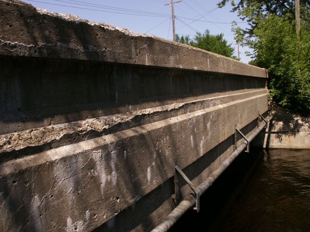
This bridge was once an attractive example of a utilitarian bridge design that Michigan built for shorter crossings during the late 1910s and into the 1920s. Today it is a sorry sight with extreme spalling destroying the simple beauty that this bridge's girders once displayed in the form of simple accents such as shapes of inset rectangles. The bridge is a blatant reminder of the cost (both money and history) of using salt to de-ice roads. Despite numerous de-icing alternatives that are non-corrosive and are also friendlier to the environment, most places continue to use salt to de-ice roads during Michigan's winter season, which often seems to be an endless season of snow and clouds.
Compared to other surviving bridges of this type in the state, the bridge is a relatively long example of a straight-chord girder span in Michigan.
It is unfortunate that this bridge is in such poor shape, as it is in a very scenic location and if it could be restored it would have looked quite nice where it is.
![]()
![]()
![]()
This historic bridge has been demolished. This map is shown for reference purposes only.
Coordinates (Latitude, Longitude):
Search For Additional Bridge Listings:
Bridgehunter.com: View listed bridges within 0.5 miles (0.8 kilometers) of this bridge.
Bridgehunter.com: View listed bridges within 10 miles (16 kilometers) of this bridge.
Additional Maps:
Google Streetview (If Available)
GeoHack (Additional Links and Coordinates)
Apple Maps (Via DuckDuckGo Search)
Apple Maps (Apple devices only)
Android: Open Location In Your Map or GPS App
Flickr Gallery (Find Nearby Photos)
Wikimedia Commons (Find Nearby Photos)
Directions Via Sygic For Android
Directions Via Sygic For iOS and Android Dolphin Browser
USGS National Map (United States Only)
Historical USGS Topo Maps (United States Only)
Historic Aerials (United States Only)
CalTopo Maps (United States Only)

© Copyright 2003-2025, HistoricBridges.org. All Rights Reserved. Disclaimer: HistoricBridges.org is a volunteer group of private citizens. HistoricBridges.org is NOT a government agency, does not represent or work with any governmental agencies, nor is it in any way associated with any government agency or any non-profit organization. While we strive for accuracy in our factual content, HistoricBridges.org offers no guarantee of accuracy. Information is provided "as is" without warranty of any kind, either expressed or implied. Information could include technical inaccuracies or errors of omission. Opinions and commentary are the opinions of the respective HistoricBridges.org member who made them and do not necessarily represent the views of anyone else, including any outside photographers whose images may appear on the page in which the commentary appears. HistoricBridges.org does not bear any responsibility for any consequences resulting from the use of this or any other HistoricBridges.org information. Owners and users of bridges have the responsibility of correctly following all applicable laws, rules, and regulations, regardless of any HistoricBridges.org information.
![]()