

View Information About HSR Ratings
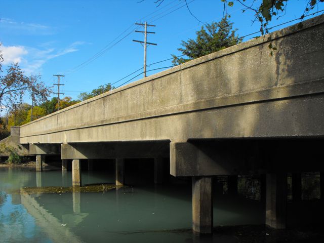
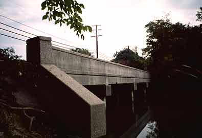
This bridge is not the most attractive bridge visually, nor is it the oldest bridge around. However the number of reinforced continuous concrete slab bridges of decent size which retain integrity is relatively low in the state. The Historic Bridge Inventory decided this bridge was eligible for listing in the National Register of Historic Places as a representative example. There are two bridges of this sort on Grosse Ile, both considered historic by the inventory. The bridge does indeed retain good integrity including a marble plaque cast into the guardrails. The guardrail design is plain, but unusual and unlike other bridges in the state. Wayne County Road Commission was noted for being innovative and trying new things, and as such historic bridges in Wayne County often bear little resemblance to bridges built during the same periods in other Michigan counties.
Information and Findings From Michigan Historic Sites Online
Ferry Street stretches from the East River to the West River roads on Grosse Ile, north of Grosse Ile Parkway. The Ferry Street Bridge passes over the Thorofare Canal east of Meridian, in an exurban residential area. The railings of the bridge are solid concrete parapets with an incised horizontal line near the top. White marble bridge plates at he northeast and southeast ends identify the bridge as Job 413 of the Wayne County Road Commission. There is an open expansion joint between the roadway and the sidewalks along each side. The bridge is supported by three bents which feature square concrete posts with chamfered edges. Statement of Significance According to the Wayne County Road Commission's 1945-1946 annual report, the county maintained "138 modern river bridges over 30-foot span," plus "more than 50 bridges on secondary roads which are being gradually replaced as funds become available and as the necessity for their replacement demands." In the next year, the old township bridge at Ferry Street, an 85-foot Pratt truss, apparently rose to the top of the list, and was replaced with the present structure. The commission's 1946-1947 annual report included a photograph of a similar structure (Graham Road over the Rouge River), with the caption: "This is typical bridge construction for township roads." Development of the Lodge Expressway (M-10) took most of the commission's energy during this period; the Ferry Street Bridge was one of only three township road bridges built in 1947. The Wayne County Road Commission used the continuous concrete slab as a standard bridge plan in the years following World War II, presumably in part to minimize the use of steel, which was expensive and difficult to obtain during this period. The Ferry Street Bridge was designed under the supervision of chief designer Julian C. Mead, who was employed by the road commission from 1921 to 1957. This is one of the bridges that should be considered for National Register designation under Criteria A and C as an example of the evolution of the road commission's bridge design. |
![]()
![]()
![]()
Coordinates (Latitude, Longitude):
Search For Additional Bridge Listings:
Bridgehunter.com: View listed bridges within 0.5 miles (0.8 kilometers) of this bridge.
Bridgehunter.com: View listed bridges within 10 miles (16 kilometers) of this bridge.
Additional Maps:
Google Streetview (If Available)
GeoHack (Additional Links and Coordinates)
Apple Maps (Via DuckDuckGo Search)
Apple Maps (Apple devices only)
Android: Open Location In Your Map or GPS App
Flickr Gallery (Find Nearby Photos)
Wikimedia Commons (Find Nearby Photos)
Directions Via Sygic For Android
Directions Via Sygic For iOS and Android Dolphin Browser
USGS National Map (United States Only)
Historical USGS Topo Maps (United States Only)
Historic Aerials (United States Only)
CalTopo Maps (United States Only)

© Copyright 2003-2025, HistoricBridges.org. All Rights Reserved. Disclaimer: HistoricBridges.org is a volunteer group of private citizens. HistoricBridges.org is NOT a government agency, does not represent or work with any governmental agencies, nor is it in any way associated with any government agency or any non-profit organization. While we strive for accuracy in our factual content, HistoricBridges.org offers no guarantee of accuracy. Information is provided "as is" without warranty of any kind, either expressed or implied. Information could include technical inaccuracies or errors of omission. Opinions and commentary are the opinions of the respective HistoricBridges.org member who made them and do not necessarily represent the views of anyone else, including any outside photographers whose images may appear on the page in which the commentary appears. HistoricBridges.org does not bear any responsibility for any consequences resulting from the use of this or any other HistoricBridges.org information. Owners and users of bridges have the responsibility of correctly following all applicable laws, rules, and regulations, regardless of any HistoricBridges.org information.
![]()
 Narrative Description