

View Information About HSR Ratings
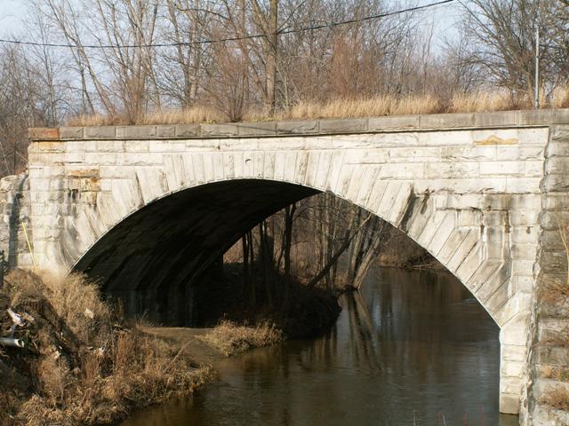
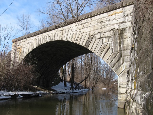
Michigan is not a state known for having many stone arch bridges. This bridge might be sneered at by people from out in the eastern United States, but here in Michigan this is one of the state's largest, oldest, and most impressive stone arch structures. The actual structure is in decent condition but is abandoned. The old railroad grade has been removed for an eternity from the looks of it. The rail line and the deck of this bridge is quite high from the terrain immediately surrounding it, which is the small valley that Bean Creek is in. There was originally a dirt approach to this bridge.
Randy, a website visitor, provided the following additional information regarding this bridge:
I spent my younger years watching NYC diesels passing thru her front yard. Most of Hudson is at the height of this bridge. The tracks from the east came in at ground level and then stayed at that level as they came to this bridge. The approach was a small fill on the east side. The fill is now gone and replaced by the parking lot to Bobbye's Pizza. The west approach was a fill of about 80-100 yards. At that point was another limestone block bridge which crossed over the Cincinnati Northern. To the west of this bridge was a short fill and then to normal elevation thru town. This bridge, the bridge over the Cincinnati Northern, and the station further to the west were all constructed of limestone. The station, railroad bridge, and west abutement for this bridge were torn down and dumped in Saurkraut Lake (basically a mud pit in the southwest corner of M-34 - US127 junction. A local history book called "Reflections On The Bean" has this bridge on the cover with a ten wheeler crossing it.
Information and Findings From Michigan Historic Sites OnlineNarrative Description Crossing Bean Creek a short distance north of Main Street in Hudson, the bridge is a single-span, stone arch bridge measuring about 75 feet long and 42 feet wide across the top, with a span length of about 65 feet. Standing on an abandoned section of the old Lakeshore and Michigan Southern Railroad, the structure is finished in rockface ashlar, the voussoirs being rusticated. The keystone contains a recessed oval panel carved with the date of construction-- 1871. Because the structure has not had to support traffic for many years, it is in an excellent state of repair. Statement of Significance The Bean Creek Bridge is one of Michigan's most impressive masonry arch bridges. It is outstanding for its size, for the quality of its masonry construction, and for its fine state of preservation. The bridge was constructed in 1871 by the Lakeshore and Michigan Southern Railroad, which took over this line in 1869. The bridge replace a wood tressle bridge which, built about 1840, was a part of the sixty-six miles of the Southern Michigan Railroad built by the State of Michigan between 1839 and 1843. |
This bridge is tagged with the following special condition(s): Unorganized Photos
![]()
![]()
![]()
![]()
![]()
Coordinates (Latitude, Longitude):
Search For Additional Bridge Listings:
Bridgehunter.com: View listed bridges within 0.5 miles (0.8 kilometers) of this bridge.
Bridgehunter.com: View listed bridges within 10 miles (16 kilometers) of this bridge.
Additional Maps:
Google Streetview (If Available)
GeoHack (Additional Links and Coordinates)
Apple Maps (Via DuckDuckGo Search)
Apple Maps (Apple devices only)
Android: Open Location In Your Map or GPS App
Flickr Gallery (Find Nearby Photos)
Wikimedia Commons (Find Nearby Photos)
Directions Via Sygic For Android
Directions Via Sygic For iOS and Android Dolphin Browser
USGS National Map (United States Only)
Historical USGS Topo Maps (United States Only)
Historic Aerials (United States Only)
CalTopo Maps (United States Only)

© Copyright 2003-2025, HistoricBridges.org. All Rights Reserved. Disclaimer: HistoricBridges.org is a volunteer group of private citizens. HistoricBridges.org is NOT a government agency, does not represent or work with any governmental agencies, nor is it in any way associated with any government agency or any non-profit organization. While we strive for accuracy in our factual content, HistoricBridges.org offers no guarantee of accuracy. Information is provided "as is" without warranty of any kind, either expressed or implied. Information could include technical inaccuracies or errors of omission. Opinions and commentary are the opinions of the respective HistoricBridges.org member who made them and do not necessarily represent the views of anyone else, including any outside photographers whose images may appear on the page in which the commentary appears. HistoricBridges.org does not bear any responsibility for any consequences resulting from the use of this or any other HistoricBridges.org information. Owners and users of bridges have the responsibility of correctly following all applicable laws, rules, and regulations, regardless of any HistoricBridges.org information.
![]()