

View Information About HSR Ratings
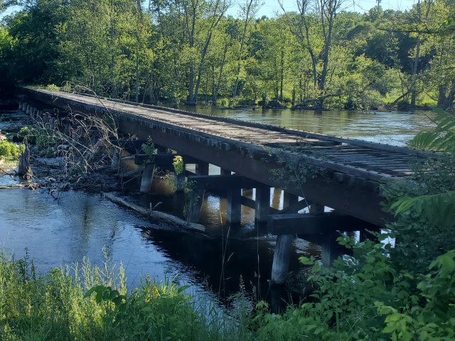
This simple steel stringer bridge on timber bents is a remnant of this abandoned railroad line and the paper mill complex that gave Parchment its name. This bridge carried railroad tracks over the river and through to the paper mill buildings once located immediately north of the bridge.
Given how much else of this heritage that has been destroyed, this railroad bridge is now locally significant as a rare surviving remnant of the paper mill industry.
Few cities have had less interest or respect for their heritage than Parchment. Parchment was a company town created by the Kalamazoo Vegetable Parchment Company which made what was essentially wax paper. Over the years, the company went through some ownership changes until closing in the early 2000s. The paper mill complex consisted of a ca. 1910s Mill 1 complex and a 1920s Mill 2 complex which also had a smaller set of buildings called Mill 3. Once these paper mills were closed, most of the equipment was auctioned off. The equipment was removed from the buildings destructively, leaving huge holes in some buildings. The mills stood abandoned for many years, until eventually Mill 1 was demolished. This was the worst offense of the city as these buildings were the oldest and had a lot more aesthetic character than the Mill 2 buildings. They would have made outstanding candidates for adaptive reuse, perhaps as mixed used developments... which ironically was what the city thought would happen to the property after demolition, but without the unique buildings. This plan did not work, and nothing much has been built in the footprint other than a new road, a soft serve ice cream stand and a Dollar General. The Dollar General was not new business for the city, it simply moved from an older strip mall in the city, which did not sell to a new business as of the time of this writing and remained vacant in 2022. A far cry from the business and residents a restored Mill 1 might have attracted, that is for sure. Parchment should have looked to the successful adaptive reuses of mill buildings in the eastern United States, where such buildings of this style are more common. Following the unprofitable attempt to redevelop the Mill 1 property, Mill 2 stood standing for even longer, but as of 2022, a warehouse is being built next to it, and the mill might be demolished as a result. Once Mill 2 is demolished the only remnants of the very buildings that gave the city its name will be the (also abandoned) company administration office building. The bridge, also, will be a surviving remnant of the mills. Perhaps it should be turned into a rail-trail, with interpretive signage describing all the history that has been lost, so future generations might not wonder why someone would name a city "Parchment" because without a connection to this rich history, all Parchment will be is a city with a name weirder than Kalamazoo.
HistoricBridges.org gained possession of a set of photos of this mill after it had been abandoned, but has been unsure what to do with them, or where to post them. Buildings are not the focus of this website, although these buildings had beautiful riveted trusses inside, and as a Western Michigan University graduate, the author of this website felt a connection to this aspect of history in the Kalamazoo area. This page seems the closest match for a way to honor the paper mills and share these photos, since this bridge was a critical part of the railroad infrastructure that once serviced the paper mills. Aerial photos showed two railroad lines once passed through or alongside the mills.
These abandoned mill photos are being included as a single massive unorganized gallery on this page for now until time allows for them to be organized.

Above: Historical 1914 advertisement for Kalamazoo Vegetable Parchment.

Above: The abandoned power house of Mill 1, Kalamazoo Vegetable Parchment Company. This was located a short distance north of the bridge, and likely received shipments of coal from the railroad. Photo Credit: Anonymous.

Above: ca. 1940 photo showing railroad tracks once present at the mill.

Above: Historical photo showing the Glendale Building (part of the Mill 2 area) with railroad tracks in the foreground.
This bridge is tagged with the following special condition(s): Unorganized Photos
![]()
![]()
![]()

![]()
![]()

![]()
Coordinates (Latitude, Longitude):
Search For Additional Bridge Listings:
Bridgehunter.com: View listed bridges within 0.5 miles (0.8 kilometers) of this bridge.
Bridgehunter.com: View listed bridges within 10 miles (16 kilometers) of this bridge.
Additional Maps:
Google Streetview (If Available)
GeoHack (Additional Links and Coordinates)
Apple Maps (Via DuckDuckGo Search)
Apple Maps (Apple devices only)
Android: Open Location In Your Map or GPS App
Flickr Gallery (Find Nearby Photos)
Wikimedia Commons (Find Nearby Photos)
Directions Via Sygic For Android
Directions Via Sygic For iOS and Android Dolphin Browser
USGS National Map (United States Only)
Historical USGS Topo Maps (United States Only)
Historic Aerials (United States Only)
CalTopo Maps (United States Only)

© Copyright 2003-2025, HistoricBridges.org. All Rights Reserved. Disclaimer: HistoricBridges.org is a volunteer group of private citizens. HistoricBridges.org is NOT a government agency, does not represent or work with any governmental agencies, nor is it in any way associated with any government agency or any non-profit organization. While we strive for accuracy in our factual content, HistoricBridges.org offers no guarantee of accuracy. Information is provided "as is" without warranty of any kind, either expressed or implied. Information could include technical inaccuracies or errors of omission. Opinions and commentary are the opinions of the respective HistoricBridges.org member who made them and do not necessarily represent the views of anyone else, including any outside photographers whose images may appear on the page in which the commentary appears. HistoricBridges.org does not bear any responsibility for any consequences resulting from the use of this or any other HistoricBridges.org information. Owners and users of bridges have the responsibility of correctly following all applicable laws, rules, and regulations, regardless of any HistoricBridges.org information.
![]()