

View Information About HSR Ratings
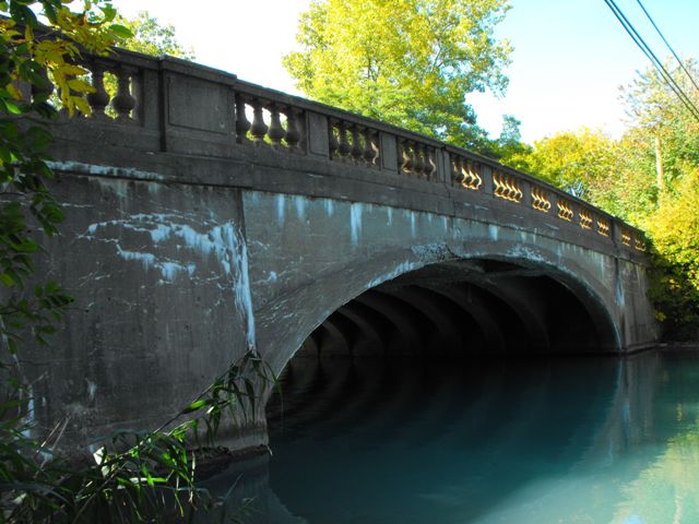
This bridge is extremely significant because it is an example of Wayne County's rare cantilevered concrete arch bridges. These unusual bridges defy attempts at classification, and have also been described as curved t-beam bridges instead of arch bridges, because the arch is actually formed of individual beams rather than a solid arch structure as is normally the case with closed spandrel arch bridges. Wayne County built a number of these bridges across the county, and several examples remain today. A cantilevered concrete arch does not function like a traditional arch. Traditional arch bridges require the arch to be a complete and connected arch to function. This arch bridge does not function in that way. Each half of each arch spans is a cantilever arm that is structurally independent from the other half of the arch in that span. These cantilever arms support a suspended span which is essentially a reinforced concrete slab in the center of the bridge. Looking closely at this bridge, two seams are visible on the side of the arch, marking where the cantilever arms end and the suspended span begins.
Information and Findings From Michigan Historic Sites OnlineNarrative Description Grosse Ile is the largest island in the Detroit River, located near its mouth at Lake Erie. The area between Grosse Ile and downtown Detroit, about 20 miles to the northeast, experienced intense industrial development in the early twentieth century, but the island developed as an exclusive residential area. Substantial nineteenth and twentieth century houses on large lots surround the Parke Lane Road Bridge. The properties to the east are on the shore of the Detroit River. The bridge's graceful concrete cantilevered arch, which includes an 18-foot cantilevered section, is complemented by concrete balustrade railings with urn-shaped spindles. Orange pebble aggregate adds color and texture to the spindles, and to octagonal lamp standards on each end of the railing. The lamp globes are missing. Otherwise, the bridge retains excellent integrity. Statement of Significance Grosse Ile's written history began in 1679, when it was described by missionary and explorer Father Hennepin. It gained a railroad in 1873, when the Chicago and Canadian Southern Railroad completed a bridge from the Michigan mainland, lying across the Trenton Channel to the west; the link to Canada was by ferry. Although the island was surveyed in 1808, it did not become a separate township until 1914, when it split from Monguagon Township. A writer in 1922 observed: "Grosse Ile is famed as an island of beautiful homes and large estates, many of which are occupied by descendents of the old families associated with the early history of the island." It also housed a naval base and airport by the 1920s. In the late nineteenth or early twentieth century, the township erected a hand operated swing bridge to carry Park Road (now Parke Lane Road) over the Thorofare Canal, which crosses the northern half of the island on a northeast-southeast diagonal. By 1929, this narrow, lightweight structure was obsolete sue to increases in traffic volume and vehicle weight. In addition, the piles supporting the bridge were rapidly deteriorating. The old structure was replaced by an exceptionally attractive concrete cantilevered-arch span. The county road commission's 1928-1929 annual report observed that "the beautiful lines of the arch of this bridge surmounted by its ornamental handrail and cluster lighting is in keeping with the surroundings." County road commission plates on the northwest and southeast railing ends identify the bridge as "Job No. 328," built in 1929. Plates on the southwest and northeast ends identify it as a state reward bridge, and give a construction date of 1930. The state highway department included a photograph of the completed structure in its 1929-1930 biennial report. As a noteworthy example of aesthetically pleasing design, and as an interesting representative of concrete cantilevered-arch construction, the Parke Lane Road Bridge is eligible for the National Register under Criterion C. As an outstanding product of the Wayne County Road Commission's bridge engineers, the bridge also qualifies under Criterion A. |
![]()
![]()
![]()
Coordinates (Latitude, Longitude):
Search For Additional Bridge Listings:
Bridgehunter.com: View listed bridges within 0.5 miles (0.8 kilometers) of this bridge.
Bridgehunter.com: View listed bridges within 10 miles (16 kilometers) of this bridge.
Additional Maps:
Google Streetview (If Available)
GeoHack (Additional Links and Coordinates)
Apple Maps (Via DuckDuckGo Search)
Apple Maps (Apple devices only)
Android: Open Location In Your Map or GPS App
Flickr Gallery (Find Nearby Photos)
Wikimedia Commons (Find Nearby Photos)
Directions Via Sygic For Android
Directions Via Sygic For iOS and Android Dolphin Browser
USGS National Map (United States Only)
Historical USGS Topo Maps (United States Only)
Historic Aerials (United States Only)
CalTopo Maps (United States Only)

© Copyright 2003-2025, HistoricBridges.org. All Rights Reserved. Disclaimer: HistoricBridges.org is a volunteer group of private citizens. HistoricBridges.org is NOT a government agency, does not represent or work with any governmental agencies, nor is it in any way associated with any government agency or any non-profit organization. While we strive for accuracy in our factual content, HistoricBridges.org offers no guarantee of accuracy. Information is provided "as is" without warranty of any kind, either expressed or implied. Information could include technical inaccuracies or errors of omission. Opinions and commentary are the opinions of the respective HistoricBridges.org member who made them and do not necessarily represent the views of anyone else, including any outside photographers whose images may appear on the page in which the commentary appears. HistoricBridges.org does not bear any responsibility for any consequences resulting from the use of this or any other HistoricBridges.org information. Owners and users of bridges have the responsibility of correctly following all applicable laws, rules, and regulations, regardless of any HistoricBridges.org information.
![]()