HistoricBridges.org Menu: HistoricBridges.org Menu:


We Recommend:
Bach Steel - Experts at historic truss bridge restoration.

HistoricBridges.org: Bridge Browser

Old US-41 Peshekee River Bridge

Trunk Line Bridge Number 1

Old US-41 Peshekee River Bridge

Primary Photographer(s): Nathan Holth

Bridge Documented: October 1, 2012 and November 13, 2021

View Photos
and Videos
View Maps
and Links

Facility Carried / Feature Intersected
Abandoned US-41 Alignment Over Peshekee River
Location
Rural: Marquette County, Michigan: United States
Structure Type
Concrete Through Girder, Fixed
Construction Date and Builder / Engineer
1914 By Builder/Contractor: Powell and Mitchell of Marquette, Michigan and Engineer/Design: Michigan State Highway Department
Rehabilitation Date
Not Available or Not Applicable
Main Span Length
40.0 Feet (12.2 Meters)
Structure Length
240.0 Feet (73.2 Meters)
Roadway Width
15 Feet (4.57 Meters)
Spans
6 Main Span(s)
Inventory Number
Not Applicable

Historic Significance Rating (HSR)
View Information About HSR Ratings

Bridge Documentation

View Archived National Bridge Inventory Report - Has Additional Details and Evaluation

How many states can claim in the 21st Century to still have the first state highway bridge ever built in the state still standing? Given that such a bridge would be very old, and given that state highways tend to have higher traffic volumes, it is unlikely that such a bridge would survive in a particular state. However, Michigan can in fact claim to have the first bridge ever built for Michigan's state trunk line system still standing! The primary reason that this bridge survives today is likely because it did not serve as a trunk line bridge for very long. By 1930, the bridge was replaced with a steel stringer bridge on a new and improved alignment for the trunk line. As such, the concrete girder bridge was abandoned, and never needed to be demolished and replaced. If it had continued to serve trunk line traffic it would surely have been replaced, if for no other reason than that the bridge would end up being too narrow for state trunk line traffic. In fact, even the 1930 bridge has not survived, since it was replaced in 1995.

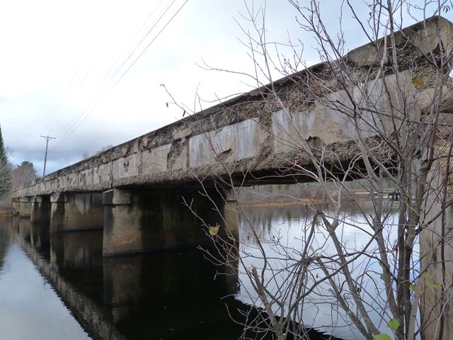
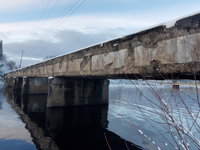
As such, the bridge is highly significant since it marks the beginning of bridge construction by Michigan's state highway agency, then called the Michigan State Highway Department and today called Michigan Department of Transportation. The bridge is also structurally significant. It is the longest straight chord concrete through girder bridge in Michigan. It would be the longest concrete girder of any type, except that the Mottville Bridge, a curved chord through girder, has it beat. However, no other concrete girder in Michigan has more spans than the Peshekee River Bridge, which has six spans. It is unusual to see the concrete through girder type, which was common for short crossings, used in a multi-span format for a longer river crossing. Finally, the bridge appears to be the oldest concrete girder in Michigan. Its age may be why the bridge stylistically does not follow the state standard plans for straight chord through girder bridges, which generally date from 1916 onward. The Peshekee River Bridge is far more simple in appearance than the already simple appearance of those state standard girders. The only architectural detailing on the bridge is simple inset rectangles on the outside of the girders. The bridge also does not have any bronze plaques that are a trademark of most state trunk line bridges. Instead, a simple casting is in the girders reading "State Trunk Line Bridge 1914".

The bridge today continues to sit abandoned, but available to pedestrians within Van Riper State Park. As such, the bridge is today owned by the DNR. Despite the fact that the bridge has enjoyed a life away from traffic and corrosive winter deicing salts, the bridge is nevertheless severely deteriorated. Widespread and severe spalling is present on the bridge. The deck's deterioration is not helped by the fact that dirt has built up on the deck and now grass grows on the bridge. All of this traps moisture on the deck which causes deterioration. Standing water was observed on the bridge deck during the field visit because the water has no way to drain off the deck. The widespread deterioration of the bridge has led to a weakening of the concrete girders. If viewed from the right angle, a slight sagging of each girder span in between piers can be seen.

Thank you to Frank Paris for scanning the historical photos on this page, which are held by the Marquette County Road Commission.

Above: A post-1930 historical photo of Trunk Line Bridge #1, with the 1930 bridge visible in the background.

A historical photo showing the 1930 replacement bridge and alignment which ended Trunk Line Bridge #1's service as a Trunk Line Bridge.

Information and Findings From Michigan Historic Bridge Inventory

Narrative Description

This multiple-span concrete bridge is located in the Champion Beach County Park, about five miles east of the village of
Michigamme. The structure carries an abandoned segment of US-41 over the Peshekee River. It is situated between the current
highway bridge (to the north) and the steel plate girder bridge of the Soo Line Railroad (to the south). Built in 1914 by the
Michigan State Highway Department, the bridge is comprised of a six 40-foot concrete through girders, carried by full-height
concrete abutments and solid concrete piers with bullnosed cutwaters. The bridge illustrates prototypical MSHD design and
detailing, with two straight girders that carry the concrete slab deck. The modest architectural expression is provided by
recessed rectangular panels in the girder walls, which are capped with heavy concrete copings. Cast into the guardrails on both
sides is "State Trunk Line Bridge 1914."

In 1913 the Michigan State Legislature passed the State Trunk Line Act, which authorized the designation of a trunk-line network
totaling nearly 3000 miles. The act stipulated that the state highway department would design, build and maintain trunk line
bridges spanning 30 feet of more, if the county or local government improved three miles of adjacent road. Soon after its
passage, a mainline route across Marquette County was designated. The route extended from Marquette, the county seat, westward
through Negaunee and Ishpeming to Michigamme on the Baraga County line. Near Michigamme it crossed the Peshekee River. To entice
the state highway department to build a bridge here, the Marquette County Road Commission built a three-mile stretch of the road
in 1913. The department approved the bridge, turning its design over to MSHD Bridge Engineer C.V. Dewart.

For the crossing, Dewart delineated this large-scale concrete bridge, designating it as Trunk Line Bridge No. 1. The structure
would be massive, extending 240 feet and consuming some 600 cubic yards of concrete. It featured, according to MSHD, "reinforced
concrete construction throughout, in which all steel is bedded in concrete, which makes an absolutely permanent structure." The
department hired contractors Powell and Mitchell of Marquette to build the structure. They completed it in 1914 for a total cost
of $11,129.70. The trunk line was later incorporated into US-41, and this bridge carried increasingly heavy traffic until its
subsequent abandonment in a highway re-alignment. Today it stands deteriorating and overgrown in a county park.

The concrete through girder that MSHD built here in 1914 used a design that the agency had just developed as a medium-span
standard. During the 1910s and 1920s, the highway department delineated straight girders in five-foot increments between 30 and
50 feet for use in a wide variety of application.

"The reinforced concrete through girder is the design generally employed for spans from thirty to fifty feet in both the eighteen
and twenty-foot clear roadway from curb to curb," MSHD stated in its Seventh Biennial Report. "This design lends itself in the
majority of cases on account of its very shallow floor system, thereby giving the waterway a maximum clearance under elevation of
roadway crossing the bridge."

By 1930 the through girder had largely fallen out of favor with the state and county highway departments, but before it was
discontinued, perhaps hundreds of thes utilitarian structures were built throughout Michigan. The Trunk Line Bridge No. 1 in
Marquette county is technologically significant as the prototype for this important design. It is also historically significant
as the first trunk line bridge designed by the state highway department and as a pivotal crossing on one of the Upper Peninsula's
most important routes. Although deteriorated, the Trunk Line Bridge No. 1 is today distinguished as one of Michigan's most
important vehicular bridges.


This bridge is tagged with the following special condition(s): Unorganized Photos

Divider

Photo Galleries and Videos: Old US-41 Peshekee River Bridge


View Photo Gallery

Bridge Photo-Documentation

Original / Full Size Photos
A collection of overview and detail photos. This gallery offers photos in the highest available resolution and file size in a touch-friendly popup viewer.
Alternatively, Browse Without Using Viewer

Divider

View Photo Gallery

Bridge Photo-Documentation

Mobile Optimized Photos
A collection of overview and detail photos. This gallery features data-friendly, fast-loading photos in a touch-friendly popup viewer.
Alternatively, Browse Without Using Viewer

Divider

View Photo Gallery

Additional Unorganized Photos

Original / Full Size Photos
A supplemental collection of photos that are from additional visit(s) to the bridge and have not been organized or captioned. This gallery offers photos in the highest available resolution and file size in a touch-friendly popup viewer.
Alternatively, Browse Without Using Viewer

Divider

View Photo Gallery

Additional Unorganized Photos

Mobile Optimized Photos
A supplemental collection of photos that are from additional visit(s) to the bridge and have not been organized or captioned. This gallery features data-friendly, fast-loading photos in a touch-friendly popup viewer.
Alternatively, Browse Without Using Viewer

Divider

Maps and Links: Old US-41 Peshekee River Bridge

Coordinates (Latitude, Longitude):

Search For Additional Bridge Listings:

Bridgehunter.com: View listed bridges within 0.5 miles (0.8 kilometers) of this bridge.

Bridgehunter.com: View listed bridges within 10 miles (16 kilometers) of this bridge.

HistoricBridges.org Bridge Browser: View listed bridges within 0.5 miles (0.8 kilometers) of this bridge.

HistoricBridges.org Bridge Browser: View listed bridges within 10 miles (16 kilometers) of this bridge.

2021 National Bridge Inventory: View listed bridges within 0.5 miles (0.8 kilometers) of this bridge.

Additional Maps:

Google Maps

Google Streetview (If Available)

Bing Maps

OpenStreetMap

GeoHack (Additional Links and Coordinates)

Apple Maps (Via DuckDuckGo Search)

Apple Maps (Apple devices only)

MapQuest

HERE We Go Maps

ACME Mapper

Waze Map

Android: Open Location In Your Map or GPS App

Flickr Gallery (Find Nearby Photos)

Wikimedia Commons (Find Nearby Photos)

Directions Via Sygic For Android

Directions Via Sygic For iOS and Android Dolphin Browser

USGS National Map (United States Only)

Historical USGS Topo Maps (United States Only)

Historic Aerials (United States Only)

CalTopo Maps (United States Only)


Divider
 
Home Top

Divider

About - Contact

© Copyright 2003-2024, HistoricBridges.org. All Rights Reserved. Disclaimer: HistoricBridges.org is a volunteer group of private citizens. HistoricBridges.org is NOT a government agency, does not represent or work with any governmental agencies, nor is it in any way associated with any government agency or any non-profit organization. While we strive for accuracy in our factual content, HistoricBridges.org offers no guarantee of accuracy. Information is provided "as is" without warranty of any kind, either expressed or implied. Information could include technical inaccuracies or errors of omission. Opinions and commentary are the opinions of the respective HistoricBridges.org member who made them and do not necessarily represent the views of anyone else, including any outside photographers whose images may appear on the page in which the commentary appears. HistoricBridges.org does not bear any responsibility for any consequences resulting from the use of this or any other HistoricBridges.org information. Owners and users of bridges have the responsibility of correctly following all applicable laws, rules, and regulations, regardless of any HistoricBridges.org information.

Admin Login

Divider