

View Information About HSR Ratings
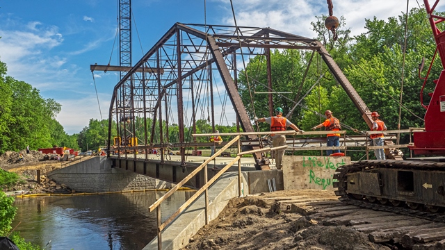
2016 Update: This bridge was technically replaced with a new bridge, but the trusses were placed on this replacement bridge as a non-structural decoration. The trusses continue to support themselves, and side from loss of floorbeams, the complete truss including bottom chord and overhead bracing remain intact.

Above: Photo by Arthur Sidner showing bridge after 2016 project. Note steel beam under the bridge.
Original Narrative
This bridge is a rare example of a pin-connected Camelback truss. The truss is shaped in such as way that it strongly has a "Camelback" shape to it, since five panels of the bridge are devoted to a horizontal top chord, giving it a somewhat unusual appearance. Also unusual is that the depth of the portal bracing is less than the depth of the sway bracing. Aside from repairs to a vertical member and an end post, the bridge trusses have excellent historic integrity with no noteworthy alterations.
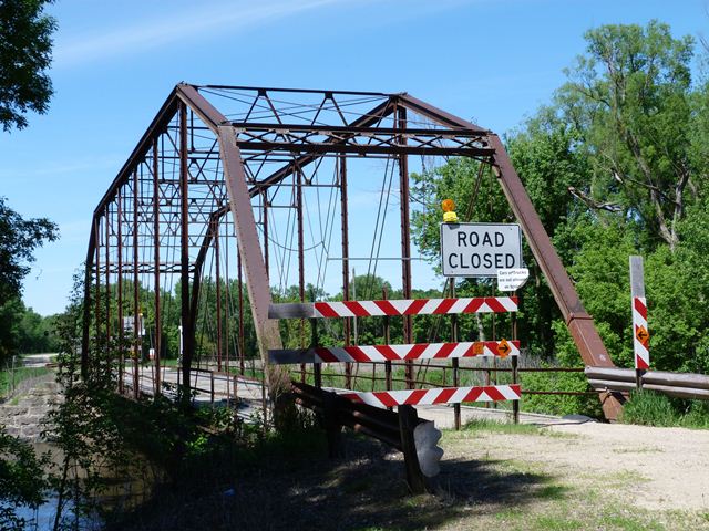
This bridge has repeatedly been threatened with demolition. The first time was when the HAER documentation was completed in 1993 following flood damage to the abutments. The HAER documentation states that the bridge was slated for demolition. This obviously never happened, since the bridge remains standing today. More recently, the bridge was closed to traffic and again threatened with demolition. The Dodd Ford Bridge Preservation Society was formed to advocate for the preservation of the bridge. They produced a YouTube videos, featuring an "Our Story" production about the bridge. The fight to save this bridge from demolition is ongoing. The story of the bridge's most recent fight for continued existence can be traced back to ca. 2007/2008 when a Section 106 Review was conducted in response to a federal grant that the county was seeking to replace the bridge. Section 106 requires consideration of feasible and prudent alternatives to demolition. The outcome of Section 106 was that in fact that replacement was avoidable and that rehabilitation was both feasible and prudent. The bridge was described as an excellent candidate for rehabilitation. This meant that if the county wanted federal help for this bridge, the county would have to agree to rehabilitate the bridge. The federal funds could not be used to replace the bridge. The county, for whatever reason, really didn't like that idea. So great was the county's dislike that the county did something that is almost unheard of: they turned down the federal money by withdrawing its application for funding. Following this somewhat unusual action by the county, the Amboy community sought other means of preservation, and applied for Minnesota Legacy Funds to supplement costs for rehabilitating the bridge for use as part of a recreational trail. They were given $100,000 to conduct an engineering assessment for that purpose. The county has now proposed the possibility of rehabilitating the bridge for low volume traffic by adding steel stringers underneath the bridge to carry the load of traffic. The county has proposed to do this using state funds and new funding from the Minnesota Legacy funds.
HistoricBridges.org's field visit revealed that despite a lack of paint, the bridge trusses are overall in outstanding condition. Even the bottom chord connections, which often are areas with substantial section loss and/or pack rust, have nearly no section loss at all. It is not clear why the bridge was even closed to traffic. If there is a severe problem with the truss, it is likely isolated in nature and easy to correct. The only thing questionable is some unusual repairs made in 1984 when metal cases were built around a damaged end post and vertical member. This repair differs from other more common repair methods, such as splicing a new member section in place, or welding plate to damaged members. These cases look like they might not provide substantial strengthening and may trap moisture and lead to deterioration.
This bridge is tagged with the following special condition(s): Trusses Converted To Decorative and Unorganized Photos
![]()
![]()
![]()
![]()
![]()

![]()
![]()
Coordinates (Latitude, Longitude):
Search For Additional Bridge Listings:
Bridgehunter.com: View listed bridges within 0.5 miles (0.8 kilometers) of this bridge.
Bridgehunter.com: View listed bridges within 10 miles (16 kilometers) of this bridge.
Additional Maps:
Google Streetview (If Available)
GeoHack (Additional Links and Coordinates)
Apple Maps (Via DuckDuckGo Search)
Apple Maps (Apple devices only)
Android: Open Location In Your Map or GPS App
Flickr Gallery (Find Nearby Photos)
Wikimedia Commons (Find Nearby Photos)
Directions Via Sygic For Android
Directions Via Sygic For iOS and Android Dolphin Browser
USGS National Map (United States Only)
Historical USGS Topo Maps (United States Only)
Historic Aerials (United States Only)
CalTopo Maps (United States Only)

© Copyright 2003-2025, HistoricBridges.org. All Rights Reserved. Disclaimer: HistoricBridges.org is a volunteer group of private citizens. HistoricBridges.org is NOT a government agency, does not represent or work with any governmental agencies, nor is it in any way associated with any government agency or any non-profit organization. While we strive for accuracy in our factual content, HistoricBridges.org offers no guarantee of accuracy. Information is provided "as is" without warranty of any kind, either expressed or implied. Information could include technical inaccuracies or errors of omission. Opinions and commentary are the opinions of the respective HistoricBridges.org member who made them and do not necessarily represent the views of anyone else, including any outside photographers whose images may appear on the page in which the commentary appears. HistoricBridges.org does not bear any responsibility for any consequences resulting from the use of this or any other HistoricBridges.org information. Owners and users of bridges have the responsibility of correctly following all applicable laws, rules, and regulations, regardless of any HistoricBridges.org information.
![]()