We Recommend:
Bach Steel - Experts at historic truss bridge restoration.
BridgeHunter.com Phase 1 is released to the public! - Visit Now
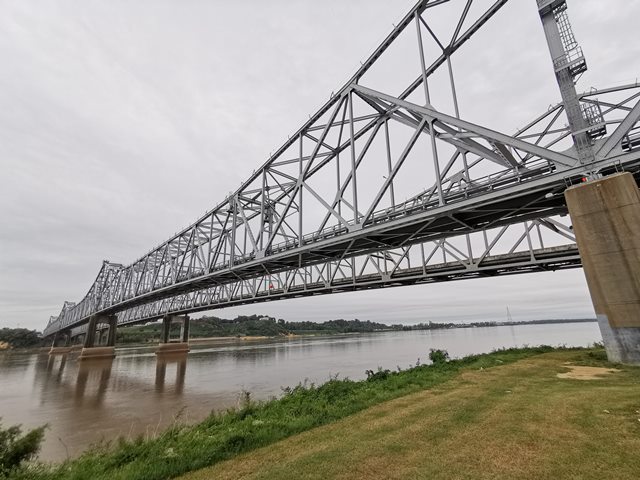
Natchez-Vidalia Bridge

Primary Photographer(s): Nathan Holth
Bridge Documented: October 14, 2019
US-84 and US-425 (Westbound) (John R. Junkin Drive) Over Mississippi River
Natchez and Vidalia: Adams County, Mississippi and Concordia Parish, Louisiana: United States
Metal Cantilever 20 Panel Rivet-Connected Warren Through Truss, Fixed and Approach Spans: Metal Continuous Deck Girder, Fixed
1940 By Builder/Contractor: Bethlehem Steel Company of Bethlehem, Pennsylvania and Dravo Contracting Company of Pittsburgh, Pennsylvania and Engineer/Design: Ash, Howard, Needles, and Tammen of New York, New York
2014
875.0 Feet (266.7 Meters)
4,205.0 Feet (1281.7 Meters)
24 Feet (7.32 Meters)
5 Main Span(s) and 6 Approach Span(s)
21000840010001A

View Information About HSR Ratings
Bridge Documentation
This bridge, today paired with a modern cantilever truss, is a very early example of a truss bridge with no v-lacing or lattice on its members. An unusual detail is that the cantilever arms hold the suspended span from the top chord, rather than extending a hanger down to the bottom chord. It is interesting to note that this unusual design detail is replicated in the companion 1990s bridge that was built next to this bridge. Bethlehem Steel Company of Bethlehem, Pennsylvania was the superstructure contractor, and Dravo Contracting Company of Pittsburgh, Pennsylvania was the substructure contractor.
View Archived National Bridge Inventory Report - Has Additional Details and Evaluation
View Historical Article About This Bridge
View Articles About 2014 Rehabilitation of this Bridge
|
Main Plaque FEDERAL WORKS AGENCYPUBLIC WORKS ADMINISTRATION JOHN M. CARMODY FEDERAL WORKS ADMINISTRATOR FRANKLIN D. ROOSEVELT PRESIDENT OF THE UNITED STATES NATCHEZ-VIDALIA BRIDGE 1938-1940 ----------------------------------- NATCHEZ HERE PASSED, IN 1543, DE SOTO'S MEN UNDER MOSCOSO. IN 1682 LA SALLE AND DE TONTI HERE VISITED THE NATCHEZ INDIANS. IN 1716 BIENVILLE HERE BUILT FT. ROSALIE AND ESTABLISHED A FRENCH SETTLEMENT. IN 1763 THE FORT WAS CEDED TO THE ENGLISH AND RENAMED FT. PANMURE. IN 1779 IT PASSED TO THE SPANIARDS. IN 1798 IT WAS OCCUPIED BY AMERICAN TROOPS. CHARTERS IN 1803, THE CITY OF NATCHEZ WAS FROM 1798 TO 1802, AND FROM 1817 TO 1821 THE CAPITAL OF MISSISSIPPI. ----------------------------------- IN THIS, THE 224TH YEAR SINCE ITS FOUNDING NATCHEZ DEDICATES TO THE PEOPLE THE NATCHEZ-VIDALIA BRIDGE |
![]()
Photo Galleries and Videos: Natchez-Vidalia Bridge
Bridge Photo-Documentation
Original / Full Size PhotosA collection of overview and detail photos. This gallery offers photos in the highest available resolution and file size in a touch-friendly popup viewer.
Alternatively, Browse Without Using Viewer
![]()
Bridge Photo-Documentation
Mobile Optimized PhotosA collection of overview and detail photos. This gallery features data-friendly, fast-loading photos in a touch-friendly popup viewer.
Alternatively, Browse Without Using Viewer
![]()
Maps and Links: Natchez-Vidalia Bridge
Coordinates (Latitude, Longitude):
Search For Additional Bridge Listings:
Bridgehunter.com: View listed bridges within 0.5 miles (0.8 kilometers) of this bridge.
Bridgehunter.com: View listed bridges within 10 miles (16 kilometers) of this bridge.
Additional Maps:
Google Streetview (If Available)
GeoHack (Additional Links and Coordinates)
Apple Maps (Via DuckDuckGo Search)
Apple Maps (Apple devices only)
Android: Open Location In Your Map or GPS App
Flickr Gallery (Find Nearby Photos)
Wikimedia Commons (Find Nearby Photos)
Directions Via Sygic For Android
Directions Via Sygic For iOS and Android Dolphin Browser
USGS National Map (United States Only)
Historical USGS Topo Maps (United States Only)
Historic Aerials (United States Only)
CalTopo Maps (United States Only)

