

View Information About HSR Ratings
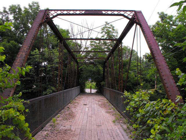
This bridge is significant as a early, rare surviving example of a bridge built by a noteworthy regional bridge company. The bridge has been closed to vehicular traffic and reconfigured for non-motorized use in its original location. No major work was done on the truss structure itself however.
The bridge has unusual detail at the sway bracing / top chord connection, where bent metal bar is curled around with a hole for the main top chord pin present. Otherwise, the bridge is traditionally composed. The truss retains good historic integrity with the exception of the loss of the original railings.
Located near the University of Missouri, this six panel bridge that is made of wrought iron is in a location where it can be enjoyed by many.
Information and Findings From Missouri's Historic Bridge InventoryBridge Features Superstructure: wrought iron, 6-panel, pin-connected
Pratt through truss Discussion of Bridge In May 1888, when J.D. Little and a large group of local citizens petitioned the Boone County Court for a new bridge over Hinkson Creek, the setting was a rural one. The city of Columbia has since grown up around the site, but the iron truss that was built that year remains much as it did when it was completed. Actually, the 1888 bridge here was preceded by an earlier structure that carried the Columbia and Providence Road; Little's petition was for a permanent iron span to replace the deteriorating timber structure. After reviewing the petition, the court directed county road and bridge commissioner W.E. Wright "to examine the old bridge and the site and report the necessity of a new bridge and the probable cost of erecting same." Wright inspected the old bridge, surveyed the site and reported back to the court that a 103-foot truss would be necessary to span the creek at this point. The county then contracted with St. Louis bridge builder H.W. Sebastian to fabricate and erect the wrought iron Pratt truss for $1750.00, and it hired local contractors Bergman and Nichols to build the stone abutments. The Hinkson Creek Bridge was completed by the end of November 1888. The truss first carried mainline wagon traffic, then later secondary car traffic, and now it is closed and barricaded. The original deck and guardrails have been replaced, but the structure otherwise remains unchanged. The Hinkson Creek Bridge is historically significant as the last remaining example from what was once an extensive group of wrought iron trusses in Boone County. It is technologically significant as an early, well-preserved example of what was a mainstay structural type in Missouri: the pin-connected Pratt through truss. The bridge is also noteworthy for its association with H.W. Sebastian. Henry Sebastian and William Vliet began building bridges from their Kansas City office in the 1870s. Sebastian split from Vliet sometime before 1879, forming H.W. Sebastian and Company in St. Louis. In 1888 - as the Hinkson Creek Bridge was under construction, in fact - he incorporated his firm as the St. Louis Bridge and Iron Works. The Hinkson Creek Bridge is the earliest remaining truss in Missouri attributable to this seminal in-state bridge builder. It is thus both historically and technologically significant. Bridge Considered Historic By Survey: Yes |
![]()
![]()
![]()
Coordinates (Latitude, Longitude):
Search For Additional Bridge Listings:
Bridgehunter.com: View listed bridges within 0.5 miles (0.8 kilometers) of this bridge.
Bridgehunter.com: View listed bridges within 10 miles (16 kilometers) of this bridge.
Additional Maps:
Google Streetview (If Available)
GeoHack (Additional Links and Coordinates)
Apple Maps (Via DuckDuckGo Search)
Apple Maps (Apple devices only)
Android: Open Location In Your Map or GPS App
Flickr Gallery (Find Nearby Photos)
Wikimedia Commons (Find Nearby Photos)
Directions Via Sygic For Android
Directions Via Sygic For iOS and Android Dolphin Browser
USGS National Map (United States Only)
Historical USGS Topo Maps (United States Only)
Historic Aerials (United States Only)
CalTopo Maps (United States Only)

© Copyright 2003-2026, HistoricBridges.org. All Rights Reserved. Disclaimer: HistoricBridges.org is a volunteer group of private citizens. HistoricBridges.org is NOT a government agency, does not represent or work with any governmental agencies, nor is it in any way associated with any government agency or any non-profit organization. While we strive for accuracy in our factual content, HistoricBridges.org offers no guarantee of accuracy. Information is provided "as is" without warranty of any kind, either expressed or implied. Information could include technical inaccuracies or errors of omission. Opinions and commentary are the opinions of the respective HistoricBridges.org member who made them and do not necessarily represent the views of anyone else, including any outside photographers whose images may appear on the page in which the commentary appears. HistoricBridges.org does not bear any responsibility for any consequences resulting from the use of this or any other HistoricBridges.org information. Owners and users of bridges have the responsibility of correctly following all applicable laws, rules, and regulations, regardless of any HistoricBridges.org information.
![]()