

View Information About HSR Ratings
This bridge was one of the largest and most significant multi-span simple-span truss bridges in the state of Missouri. It was historically and technologically significant and was found eligible for the National Register of Historic Places by the Historic Bridge Inventory. Missouri has shown little to no commitment to preserving any of the large river historic bridges under its jurisdiction. The Cape Girardeau Bridge is perhaps the most important bridge demolished, but there are many other Mississippi River and Missouri River bridges which have been being demolished at a disturbingly rapid rate. The loss and damage of history and beauty that has occurred in Missouri as a result of large river historic bridge demolition is immeasurable even over just the past ten years from the writing of this narrative in November 2009.
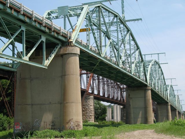
HistoricBridges.org did not make it to Missouri before this bridge was demolished. Photos of the bridge were taken and provided by Missouri Department of Transportation. Because a HistoricBridges.org visit was not made, a complete photo-documentation of the bridge is not available. However, this page has been put in place to make available to the public the excellent historical narrative that MoDOT had on file for the bridge as well as the extensive information from the Historic Bridge Inventory. It is hoped that the few photos and the narratives will help to document this incredible bridge which is gone forever. One additional overlooked detail to note about this bridge is it had unusual riveted towers on top of the truss which held electrical wires. This was an unusual feature, and since the towers appeared to be riveted and original, they were a significant and unique historic detail.
The photos HistoricBridges.org acquired from MODOT were mostly of the demolition of the historic bridge, particularly during deck removal, although their are a few photos from before demolition began. The photos are not pretty as a result, but they at least provide a look at the bridge.
There are also high quality professionally shot still photos of the implosion of the main spans of this historic bridge. If you are a true historic bridge enthusiast they will break your heart to even glance at. It is truly sickening to think that a bridge that took so much effort on the part of so many people to construct, and has stood, serving faithfully, for so very long, can be reduced to rubble in a fraction of a second. So why are these implosion photos posted on HistoricBridges.org? Because we have found that nothing drives home the reality of the risk of demolition that historic bridges face than a graphic demolition photo. They are great attention-grabbers in presentations.
With all that said, consider yourself warned. The photo gallery for this bridge contains scenes of extreme wanton and gratuitous violence done against a historic bridge. Historic bridges were harmed in the making of this photo gallery. Viewer discretion is advised.
Information and Findings From Missouri's Historic Bridge InventoryBridge Features superstructure: steel, 10-, 12- and 14-panel, rigid-connected Pennsylvania through trusses; rigid-connected Pratt deck truss approach spans substructure: concrete abutments; concrete bullnose and spill-through piers floor/decking: concrete over metal plate deck other features: upper chord and inclined end post: 2 channels with cover plate and lacing; lower chord: 2 channels with batten plates and lacing; vertical: 4 angles with batten plates and lacing; diagonal: 2 channels with batten plates and lacing; lateral bracing: 1 angle - lower, 4 angles with lacing - upper; strut: 4 angles with lattice and lacing; portal strut; 4 angles with lacing (W-frame); floor beam: I-beam; bridge plate: Glasgow Bridge / Financed By / Howard County, Saline County / Federal Aid / Appropriated By / Missouri State Highway Commission / Designed By F.W. Adgate / Consulting Engineer / Chicago, Ill. / Supervised By / Missouri State Highway Department / B.H. Piepmeier, Chief Engineer / L..I. Sverdrup, Bridge Engineer / Contractors / Substructure / Union Bridge & Const. Co. / Kansas City, Mo / Superstructure / Mt. Vernon Bridge Co. / Mt. Vernon, Ohio / Completed 1925 Discussion of Bridge This multiple-span highway bridge carries State Highway 240 over the Missouri River at Glasgow, between Saline and Howard counties. Located immediately downriver from the Illinois Central Gulf Railroad's bridge, this immense structure consists of five truss spans varying between 224 feet to 343 feet in length. The first bridge built over the Missouri River at Glasgow was the Glasgow Steel Bridge-the first all-steel bridge in the world-built in 1879 by the Chicago & Alton Railroad Company. Positioned alongside the existing railroad bridge, the highway bridge was designed in 1922 with the objective of linking vehicular traffic between Saline and Howard counties. comprised of five riveted Pennsylvania through trusses and series of deck truss and deck girder approach spans, the structure cost $619,00.00-$278.00 per lineal foot-and was financed in part by the two counties. Federal aid was also appropriated by the Missouri State Highway Commission. Designed by Consulting Engineer F. Adgate and supervised by the Missouri State Highway Department, the bridge extends some 2,244 feet in length. The contract to build the superstructure was awarded to the Mt. Vernon Bridge Company of Mt. Vernon, Ohio. The concrete substructure was built by the Union Bridge and Construction Company of Kansas City, Missouri. Throughout the years, rehabilitation efforts have taken place, including resurfacing the floor with asphalt, general painting and installation of a concrete-filled grid deck. Since its completion, the Glasgow Bridge has functioned as a strategically important state highway while retaining its structural integrity. The Glasgow Bridge, significant as one of the first over the Missouri River in this area of the state, has continuously provided a reliable year-round route to local and interstate vehicular traffic over the Missouri River since its construction. The structure is also significant as a well-preserved example of large-scale bridge construction in Missouri. Like several bridges built over the Missouri River in the 1920s, it incorporated long, fixed-span, simply supported trusses on concrete piers. The Pennsylvania trusses of the Glasgow Bridge fit well within the mainstream of great river bridge construction in the 1920s. Just as the pin-connected Whipple truss had been the industry standard for Missouri River railroad bridges in the 1880s and 1890s, the riveted Pennsylvania (or Petit) truss was the standard configuration for long-span highway bridge applications in the 1910s, 1920s and 1930s. Its name derived from extensive use in the 19th century by the Pennsylvania Railroad, the Pennsylvania truss was patented in 1875 as a refinement of the standard Pratt truss, from which it was derived. Pennsylvania trusses featured vertical compression members and two-panel diagonals in tension, like the Whipple trusses they superseded. The primary differences lay in the substitution of a polygonal top chords for economy of materials and the addition of sub-struts or sub-ties. These relatively short diagonal members severed to provide lateral support for the diagonals and stiffen the truss under heavy moving loads. Like most truss types in America, Pennsylvanias were pioneered by the railroads and were later used to carry vehicular traffic. The First polygonal-chorded bridge over the Mississippi River - the doubletrack Merchants' Bridge at St. Louis, was a Pennsylvania truss. During the bridge boom along the Missouri River in the 1920s, fifteen of the eighteen fixed-span bridges featured Pennsylvania trusses. Almost identical, they varied only in span lengths, which were determined largely by adjacent railroad bridges. Bridge Considered Historic By Survey: Yes |
![]()
![]()
![]()

![]()
![]()
![]()
![]()
![]()
This historic bridge has been demolished. This map is shown for reference purposes only.
Coordinates (Latitude, Longitude):
Search For Additional Bridge Listings:
Bridgehunter.com: View listed bridges within 0.5 miles (0.8 kilometers) of this bridge.
Bridgehunter.com: View listed bridges within 10 miles (16 kilometers) of this bridge.
Additional Maps:
Google Streetview (If Available)
GeoHack (Additional Links and Coordinates)
Apple Maps (Via DuckDuckGo Search)
Apple Maps (Apple devices only)
Android: Open Location In Your Map or GPS App
Flickr Gallery (Find Nearby Photos)
Wikimedia Commons (Find Nearby Photos)
Directions Via Sygic For Android
Directions Via Sygic For iOS and Android Dolphin Browser
USGS National Map (United States Only)
Historical USGS Topo Maps (United States Only)
Historic Aerials (United States Only)
CalTopo Maps (United States Only)

© Copyright 2003-2026, HistoricBridges.org. All Rights Reserved. Disclaimer: HistoricBridges.org is a volunteer group of private citizens. HistoricBridges.org is NOT a government agency, does not represent or work with any governmental agencies, nor is it in any way associated with any government agency or any non-profit organization. While we strive for accuracy in our factual content, HistoricBridges.org offers no guarantee of accuracy. Information is provided "as is" without warranty of any kind, either expressed or implied. Information could include technical inaccuracies or errors of omission. Opinions and commentary are the opinions of the respective HistoricBridges.org member who made them and do not necessarily represent the views of anyone else, including any outside photographers whose images may appear on the page in which the commentary appears. HistoricBridges.org does not bear any responsibility for any consequences resulting from the use of this or any other HistoricBridges.org information. Owners and users of bridges have the responsibility of correctly following all applicable laws, rules, and regulations, regardless of any HistoricBridges.org information.
![]()