We Recommend:
Bach Steel - Experts at historic truss bridge restoration.
BridgeHunter.com Phase 1 is released to the public! - Visit Now
Liberty Bridge
MO-291 Northbound Bridge

Primary Photographer(s): Nathan Holth
Bridge Documented: June 5, 2016
Sugar Creek: Jackson County, Missouri: United States
Metal Continuous 14 Panel Rivet-Connected Warren Through Truss, Fixed and Approach Spans: Metal Continuous 12 Panel Rivet-Connected Warren Deck Truss, Fixed
1949 By Builder/Contractor: Mount Vernon Bridge Company of Mount Vernon, Ohio and Engineer/Design: Sverdrup and Parcel of St. Louis, Missouri
2002
460.0 Feet (140.2 Meters)
1,882.3 Feet (573.7 Meters)
24 Feet (7.32 Meters)
2 Main Span(s) and 6 Approach Span(s)
6353

View Information About HSR Ratings
Bridge Documentation
View Archived National Bridge Inventory Report - Has Additional Details and Evaluation
View Missouri Historic Bridge Inventory Sheet For This Historic Bridge
Missouri was once home to an impressive collection of continuous and cantilever truss bridges, perhaps a larger collection than any other state. Today however, nearly all have been demolished, and nearly all that survive are planned for future demolition. Missouri has overseen one of the most complete annihilations of large-span historic truss bridges in the entire country. The loss of beauty, history, and engineering is incalculable. Bridges like this should be treasured landmarks. This bridge in particular, which today serves only northbound traffic with a newer parallel bridge serving southbound traffic, would seem to be a good candidate for long-term preservation given that the two bridges together provide four lanes for traffic. However, MoDOT has refused to (as Section 106 mitigation for demolition of similar bridges) develop a Historic Bridge Management Plan to ensure the long-term preservation of this bridge. This refusal is a strong indication that this bridge will eventually be targeted for demolition.
The southbound bridge was built in 1996.
In terms of engineering, this bridge offers a nice comparison: its approach spans are two-span continuous deck trusses, while its main spans are two span continuous through trusses. Its worth noting that two-span continuous deck truss bridges are somewhat uncommon (three-span configurations are more common).
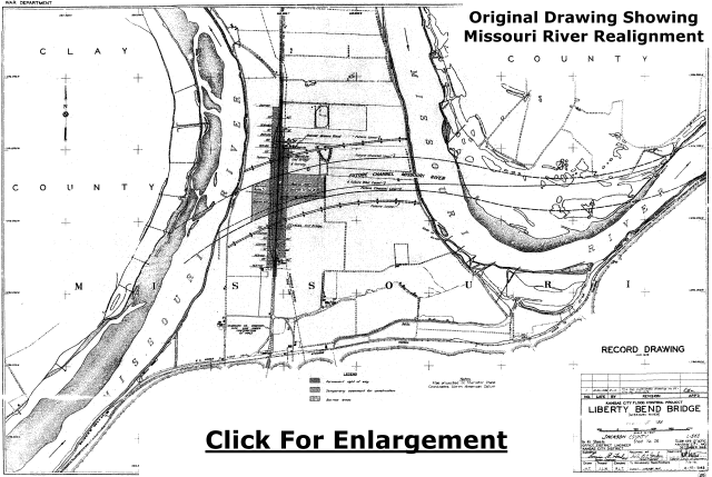
Above: This bridge built as part of an impressive project to realign the Missouri River to eliminate a long, tight bend in the river. The old river is shown in the above drawing, and the new alignment, the alignment seen today, is shown as "future channel" outlined on the drawing.

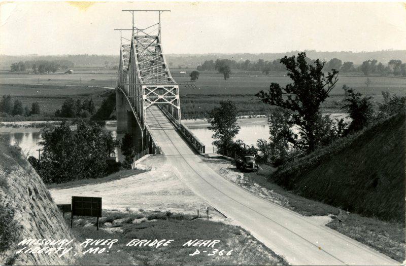
Above: This photo shows the previous Missouri bridge, which was located on the old rivet alignment north of the existing bridges seen today. This former bridge was designed by the Strauss Bascule Bridge Co. of Chicago, Illinois and built in 1929.
![]()
Photo Galleries and Videos: Liberty Bridge
Bridge Photo-Documentation
Original / Full Size PhotosA collection of overview and detail photos. This gallery offers photos in the highest available resolution and file size in a touch-friendly popup viewer.
Alternatively, Browse Without Using Viewer
![]()
Bridge Photo-Documentation
Mobile Optimized PhotosA collection of overview and detail photos. This gallery features data-friendly, fast-loading photos in a touch-friendly popup viewer.
Alternatively, Browse Without Using Viewer
![]()
CarCam: Northbound Crossing
Full Motion VideoNote: The downloadable high quality version of this video (available on the video page) is well worth the download since it offers excellent 1080 HD detail and is vastly more impressive than the compressed streaming video. Streaming video of the bridge. Also includes a higher quality downloadable video for greater clarity or offline viewing.
![]()
CarCam: Southbound Crossing
Full Motion VideoNote: The downloadable high quality version of this video (available on the video page) is well worth the download since it offers excellent 1080 HD detail and is vastly more impressive than the compressed streaming video. Streaming video of the bridge. Also includes a higher quality downloadable video for greater clarity or offline viewing.
![]()
Maps and Links: Liberty Bridge
Coordinates (Latitude, Longitude):
Search For Additional Bridge Listings:
Bridgehunter.com: View listed bridges within 0.5 miles (0.8 kilometers) of this bridge.
Bridgehunter.com: View listed bridges within 10 miles (16 kilometers) of this bridge.
Additional Maps:
Google Streetview (If Available)
GeoHack (Additional Links and Coordinates)
Apple Maps (Via DuckDuckGo Search)
Apple Maps (Apple devices only)
Android: Open Location In Your Map or GPS App
Flickr Gallery (Find Nearby Photos)
Wikimedia Commons (Find Nearby Photos)
Directions Via Sygic For Android
Directions Via Sygic For iOS and Android Dolphin Browser
USGS National Map (United States Only)
Historical USGS Topo Maps (United States Only)
Historic Aerials (United States Only)
CalTopo Maps (United States Only)


