HistoricBridges.org Menu: HistoricBridges.org Menu:


We Recommend:
Bach Steel - Experts at historic truss bridge restoration.

HistoricBridges.org: Bridge Browser

Old Appleton Bridge

Old Appleton Bridge

Primary Photographer(s): Nathan Holth and Rick McOmber

Bridge Documented: July 4, 2021 and August 28, 2021

View Photos
and Videos
View Maps
and Links

Facility Carried / Feature Intersected
Main Street Over Apple Creek
Location
Old Appleton: Cape Girardeau County, Missouri and Perry County, Missouri: United States
Structure Type
Metal 9 Panel Pin-Connected Pratt Through Truss, Fixed and Approach Spans: Metal 3 Panel Pin-Connected Queenpost Pony Truss, Fixed
Construction Date and Builder / Engineer
1879 By Builder/Contractor: H. W. Sebastian and Company of St. Louis, Missouri (St. Louis Bridge and Iron Works)
Rehabilitation Date
2005
Main Span Length
103.0 Feet (31.4 Meters)
Structure Length
161.0 Feet (49.1 Meters)
Roadway Width
13 Feet (3.96 Meters)
Spans
1 Main Span(s) and 2 Approach Span(s)
Inventory Number
Not Applicable

Historic Significance Rating (HSR)
View Information About HSR Ratings

Bridge Documentation

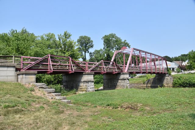
This bridge has been preserved for pedestrians with a park around it, and it is noted as a very old Pratt truss with rare Queenpost approaches. There used to be a newer historic riveted Warren pony truss bridge on nearby US-61. What happened to it? MoDOT happened. There is now an insanely ugly slab of concrete there. As such, HistoricBridges.org has no photos of that bridge.

View National Register of Historic Places Nomination Form For This Bridge

Above: Historical 1939 photo of bridge from Historic American Building Survey


This bridge is tagged with the following special condition(s): Unorganized Photos

Divider

Photo Galleries and Videos: Old Appleton Bridge


View Photo Gallery

Bridge Photo-Documentation

Original / Full Size Photos
A collection of overview and detail photos. This gallery offers photos in the highest available resolution and file size in a touch-friendly popup viewer.
Alternatively, Browse Without Using Viewer

Divider

View Photo Gallery

Bridge Photo-Documentation

Mobile Optimized Photos
A collection of overview and detail photos. This gallery features data-friendly, fast-loading photos in a touch-friendly popup viewer.
Alternatively, Browse Without Using Viewer

Divider

View Photo Gallery

Additional Unorganized Photos

Original / Full Size Photos
A supplemental collection of photos that are from additional visit(s) to the bridge and have not been organized or captioned. This gallery offers photos in the highest available resolution and file size in a touch-friendly popup viewer.
Alternatively, Browse Without Using Viewer

Divider

View Photo Gallery

Additional Unorganized Photos

Mobile Optimized Photos
A supplemental collection of photos that are from additional visit(s) to the bridge and have not been organized or captioned. This gallery features data-friendly, fast-loading photos in a touch-friendly popup viewer.
Alternatively, Browse Without Using Viewer

Divider

Maps and Links: Old Appleton Bridge

Coordinates (Latitude, Longitude):

Search For Additional Bridge Listings:

Bridgehunter.com: View listed bridges within 0.5 miles (0.8 kilometers) of this bridge.

Bridgehunter.com: View listed bridges within 10 miles (16 kilometers) of this bridge.

HistoricBridges.org Bridge Browser: View listed bridges within 0.5 miles (0.8 kilometers) of this bridge.

HistoricBridges.org Bridge Browser: View listed bridges within 10 miles (16 kilometers) of this bridge.

2021 National Bridge Inventory: View listed bridges within 0.5 miles (0.8 kilometers) of this bridge.

Additional Maps:

Google Maps

Google Streetview (If Available)

Bing Maps

OpenStreetMap

GeoHack (Additional Links and Coordinates)

Apple Maps (Via DuckDuckGo Search)

Apple Maps (Apple devices only)

MapQuest

HERE We Go Maps

ACME Mapper

Waze Map

Android: Open Location In Your Map or GPS App

Flickr Gallery (Find Nearby Photos)

Wikimedia Commons (Find Nearby Photos)

Directions Via Sygic For Android

Directions Via Sygic For iOS and Android Dolphin Browser

USGS National Map (United States Only)

Historical USGS Topo Maps (United States Only)

Historic Aerials (United States Only)

CalTopo Maps (United States Only)


Divider
 
Home Top

Divider

About - Contact

© Copyright 2003-2024, HistoricBridges.org. All Rights Reserved. Disclaimer: HistoricBridges.org is a volunteer group of private citizens. HistoricBridges.org is NOT a government agency, does not represent or work with any governmental agencies, nor is it in any way associated with any government agency or any non-profit organization. While we strive for accuracy in our factual content, HistoricBridges.org offers no guarantee of accuracy. Information is provided "as is" without warranty of any kind, either expressed or implied. Information could include technical inaccuracies or errors of omission. Opinions and commentary are the opinions of the respective HistoricBridges.org member who made them and do not necessarily represent the views of anyone else, including any outside photographers whose images may appear on the page in which the commentary appears. HistoricBridges.org does not bear any responsibility for any consequences resulting from the use of this or any other HistoricBridges.org information. Owners and users of bridges have the responsibility of correctly following all applicable laws, rules, and regulations, regardless of any HistoricBridges.org information.

Admin Login

Divider