

View Information About HSR Ratings
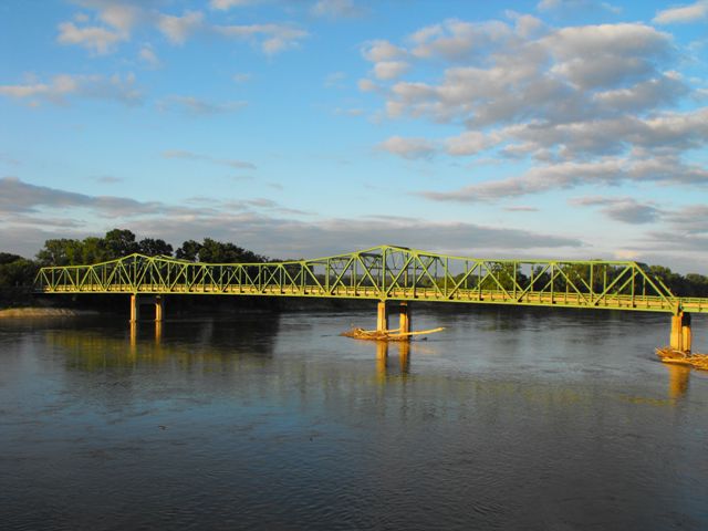
This bridge is a very important bridge for several reasons. First and foremost, it is a cantilever truss bridge. Cantilever truss bridges are few in number nationwide, yet also are being demolished at a rapid rate. In addition, the St. Francisville Bridge is significant as a rare example of a small-scale cantilever truss bridge. While there are a number of other small cantilevers in the country, they are significantly fewer in number than larger cantilever bridges. The small scale cantilever bridges have a strikingly different appearance from larger cantilever truss bridges, most notably the towers do not rise above the surrounding trusses as extensively. Finally, the bridge is significant as a large-scale construction project funded by federal Depression relief programs.
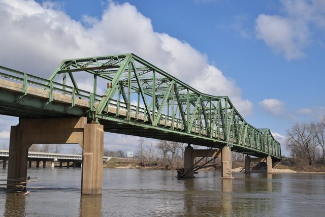
The St. Francisville Bridge contains a traditionally composed cantilever truss with cantilevers following a Warren truss configuration. The bridge also contains a suspended Warren through truss span at the center of the bridge between cantilever arms. The south end of the bridge also includes six steel stringer approach spans.
The St. Francisville Bridge had carried a major regional highway as a toll bridge since its construction. In the early 2000s this bridge was bypassed by a new bridge and SR-27 was realigned onto this new bridge. In 2003 the historic St. Francisville Bridge was converted from a toll bridge to a free bridge to carry local traffic on a county road. The bridge has continued to exist with a high degree of historic integrity and it remains essentially unaltered from its original design. In 2016 the bridge was closed to all traffic. While the truss remains in great condition, some of the piers have unusual, and extensive cracking (particularly the approach spans) and this is likely why the bridge was closed.
Information and Findings From Missouri and Iowa's Historic Bridge InventoryBridge Features Superstructure: steel, 12-panel, rigid-connected
cantilever Warren through truss Iowa's Discussion of Bridge The St. Francisville Bridge carries Iowa Route 394 and the Missouri Supplemental Route B over the Des Moines River, between Lee County, Iowa and Clark County, Missouri. A three-span, rigid-connected Warren through truss cantilevered over the river, the imposing crossing is supported by a concrete substructure with subtle Art Moderne detailing. Designed by the esteemed engineering firm of Sverdrup and Parcel, the bridge was built by F.W. Whitehead, an otherwise obscure contractor. Construction efforts were organized by the Wayland Special Road District No. 1 in Clark County, and funding was provided in part through the Federal Emergency Administration of the Public Works, under Project No. 3395-R. Since its completion in June 1937, the St. Francisville Bridge has functioned as a toll bridge, and is now Iowa's only such crossing still in non-governmental hands. Missouri's Discussion of Bridge The St. Francisville Bridge carries Missouri
Supplemental Route B, and Iowa Route 394 over the Des Moines River,
between Clark County, Missouri, and Lee County, Iowa. A three-span,
rigid-connected Warren through truss cantilevered over the river, the
imposing crossing is supported by a concrete substructure with subtle
Art Moderne detailing. Designed by the esteemed engineering firm of
Sverdrup and Parcel, the bridge was built by F.W. Whitehead, an
otherwise obscure contractor. Construction efforts were organized by the
Wayland Special Road District No. 1 in Clark County, and funding was
provided in part through the Federal Emergency Administration of the
Public Works, under Project No. 3395-R. Since its completion in June
1937, the St. Francisville Bridge has functioned as a toll bridge,
and it is now Missouri's only such crossing still in non-government
hands. As of early 1991, the fare for a one-way crossing was 25
cents. Bridge Considered Historic By Surveys: Yes View Original PDF For Missouri Historic Bridge Inventory Sheet |
This bridge is tagged with the following special condition(s): Unorganized Photos
![]()
![]()
![]()
![]()
![]()
Coordinates (Latitude, Longitude):
Search For Additional Bridge Listings:
Bridgehunter.com: View listed bridges within 0.5 miles (0.8 kilometers) of this bridge.
Bridgehunter.com: View listed bridges within 10 miles (16 kilometers) of this bridge.
Additional Maps:
Google Streetview (If Available)
GeoHack (Additional Links and Coordinates)
Apple Maps (Via DuckDuckGo Search)
Apple Maps (Apple devices only)
Android: Open Location In Your Map or GPS App
Flickr Gallery (Find Nearby Photos)
Wikimedia Commons (Find Nearby Photos)
Directions Via Sygic For Android
Directions Via Sygic For iOS and Android Dolphin Browser
USGS National Map (United States Only)
Historical USGS Topo Maps (United States Only)
Historic Aerials (United States Only)
CalTopo Maps (United States Only)

© Copyright 2003-2026, HistoricBridges.org. All Rights Reserved. Disclaimer: HistoricBridges.org is a volunteer group of private citizens. HistoricBridges.org is NOT a government agency, does not represent or work with any governmental agencies, nor is it in any way associated with any government agency or any non-profit organization. While we strive for accuracy in our factual content, HistoricBridges.org offers no guarantee of accuracy. Information is provided "as is" without warranty of any kind, either expressed or implied. Information could include technical inaccuracies or errors of omission. Opinions and commentary are the opinions of the respective HistoricBridges.org member who made them and do not necessarily represent the views of anyone else, including any outside photographers whose images may appear on the page in which the commentary appears. HistoricBridges.org does not bear any responsibility for any consequences resulting from the use of this or any other HistoricBridges.org information. Owners and users of bridges have the responsibility of correctly following all applicable laws, rules, and regulations, regardless of any HistoricBridges.org information.
![]()