

View Information About HSR Ratings
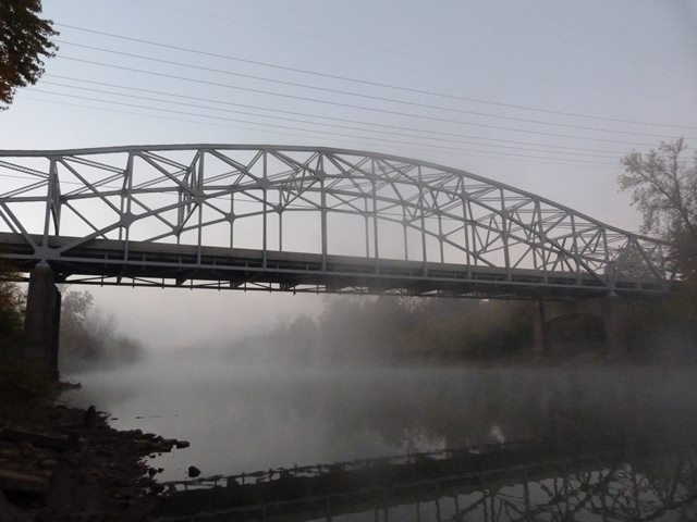
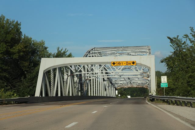
This is a bridge of unusual design, and was reportedly the first of its kind in the United States. It looks like the type of bridge normally described as a continuous truss with a suspended deck. However, the bridge is described as a "continuous tied arch." The second bridge of this type to be built was the much larger Julien Dubuque Bridge.
The unusual design of the Maramec River Bridge was the result of a desire for a particularly beautiful bridge at this location which was traditionally part of a route to recreational areas for St. Louis area residents. Designed by the Missouri State Highway Department, a department that did not place as much importance on aesthetics as some states like Oregon or Michigan, the development of an aesthetic bridge was somewhat unusual. Also unusual is for a state highway department to design and construct a bridge type that had never been built before.
The bridge today retains good historic integrity. It remains today as a striking, aesthetically pleasing bridge, and as the first of its kind in the country enjoys high levels of historical significance.
Information and Findings From Missouri's Historic Bridge InventoryBridge Features Superstructure: steel, 11-panel, rigid-connected, cantilevered tied arch Substructure: concrete abutments, wingwalls and piers Floor / Decking: concrete deck over steel stringers Other Features: upper chord, inclined end post and arch ribs: 2 built-up channels with cover plate and Discussion of Bridge This three-span steel bridge carries State Highway 21 over the Meramec River on the line between St. Louis and Jefferson counties northwest of Arnold. The Meramec River Bridge was designed by the Missouri State Highway Commission Bureau of Bridges in 1939. "Since the Meramec River Bridge is located in a region that has been called the playground of St. Louis," bridge engineer Howard Mullins stated, "an effort was made to secure a structure of reasonable esthetic fitness." MSHD engineers considered several configurations for the bridge: a continuous plate rib tied arch, a three-span continuous truss, three single-span tied arches and a suspension bridge, among others, before developing the plan for a cantilevered tied arch. As delineated by the highway department, the structure would feature a 264-foot tied arch span, cantilevered on both sides by 192-foot anchor spans. "The continuity of the trusses and the action of the arch tie produce a structure which is threefold indeterminate," Mullins wrote. "A condition of single redundancy was also produced by the double intersection diagonals at the center of the arch truss. These double diagonals were used to permit a pleasing truss outline." The superstructure was supported by concrete spill-through piers, which were in tum founded on bedrock. Designating the project as Federal Aid Project 806C(l), the highway department solicited competitive proposals in December 1939. A month later the state highway commission awarded a construction contract to the Massman Construction Company. The Kansas City based contractor commissioned the superstructural fabrication to the Stupp Brothers Bridge and Iron Company of St. Louis. Massman's construction crew used traditional falseworks under the anchor spans and erected the center span by cantilevering from the sides. To connect the arch at center-span, the men removed the end bearing shoes on the anchor spans, lifting the two arch halves slightly, before the arch was riveted and the shoes replaced. Opened to traffic later in 1940, the Meramec River Bridge consumed some 1087 tons of structural steel. Since its completion, it has functioned in place, with the replacement of its original steel grid deck with concrete as the only alteration of note. Not only was the Meramec River Bridge the first continuous tied arch built in Missouri, it was the first of its kind built in the United States. "Of the many unusual highway bridges built in recent years few were more novel than one recently constructed over the Meramec River, a short distance south of St. Louis, by the Missouri state highway department," Mullins stated. Although its 264-foot span was modest by most standards and was dwarfed by the 845-foot Julien Dubuque Bridge built over the Mississippi River three years later, the Meramec River Bridge is technologically significant as a rare incidence of structural experimentation by the state highway department and an uncharacteristic acknowledgement by the department of bridge aesthetics. It is thus noteworthy for its distinctive appearance and its atypical configuration. In essentially unaltered condition, the Meramec River Bridge is a well-preserved example of highway bridge design in the pre-war years. Bridge Considered Historic By Survey: Yes |
This bridge is tagged with the following special condition(s): Unorganized Photos
![]()
![]()
![]()
![]()
![]()
Coordinates (Latitude, Longitude):
Search For Additional Bridge Listings:
Bridgehunter.com: View listed bridges within 0.5 miles (0.8 kilometers) of this bridge.
Bridgehunter.com: View listed bridges within 10 miles (16 kilometers) of this bridge.
Additional Maps:
Google Streetview (If Available)
GeoHack (Additional Links and Coordinates)
Apple Maps (Via DuckDuckGo Search)
Apple Maps (Apple devices only)
Android: Open Location In Your Map or GPS App
Flickr Gallery (Find Nearby Photos)
Wikimedia Commons (Find Nearby Photos)
Directions Via Sygic For Android
Directions Via Sygic For iOS and Android Dolphin Browser
USGS National Map (United States Only)
Historical USGS Topo Maps (United States Only)
Historic Aerials (United States Only)
CalTopo Maps (United States Only)

© Copyright 2003-2025, HistoricBridges.org. All Rights Reserved. Disclaimer: HistoricBridges.org is a volunteer group of private citizens. HistoricBridges.org is NOT a government agency, does not represent or work with any governmental agencies, nor is it in any way associated with any government agency or any non-profit organization. While we strive for accuracy in our factual content, HistoricBridges.org offers no guarantee of accuracy. Information is provided "as is" without warranty of any kind, either expressed or implied. Information could include technical inaccuracies or errors of omission. Opinions and commentary are the opinions of the respective HistoricBridges.org member who made them and do not necessarily represent the views of anyone else, including any outside photographers whose images may appear on the page in which the commentary appears. HistoricBridges.org does not bear any responsibility for any consequences resulting from the use of this or any other HistoricBridges.org information. Owners and users of bridges have the responsibility of correctly following all applicable laws, rules, and regulations, regardless of any HistoricBridges.org information.
![]()