We Recommend:
Bach Steel - Experts at historic truss bridge restoration.
BridgeHunter.com Phase 1 is released to the public! - Visit Now
General Sullivan Bridge
Little Bay Bridge

Primary Photographer(s): Nathan Holth
Bridge Documented: June 16, 2012
Portsmouth and Dover: Rockingham County, New Hampshire and Strafford County, New Hampshire: United States
Metal Continuous (Arched) Rivet-Connected Polygonal Warren Through Truss, Fixed and Approach Spans: Metal Rivet-Connected Polygonal Warren Deck Truss, Fixed
1934 By Builder/Contractor: Lackawanna Steel Construction Corporation of Buffalo, New York and Crandrall Engineering Company of Cambridge, Massachusetts and Engineer/Design: Fay, Spofford, and Thorndike of Boston, Massachusetts
1950
275.0 Feet (83.8 Meters)
1,585.0 Feet (483.1 Meters)
24 Feet (7.32 Meters)
1 Main Span(s) and 8 Approach Span(s)
6502000002300

View Information About HSR Ratings
Bridge Documentation
This bridge's future is at risk!
Bridge Status: This bridge is slated for demolition!View Archived National Bridge Inventory Report - Has Additional Details and Evaluation
View a detailed historical narrative about this historic bridge.
View Historical Article About This Bridge

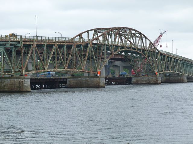
This bridge is the only surviving example of a unique design of bridge designed by Fay, Spofford, and Thorndike. The larger and earlier example was the Lake Champlain Bridge, now demolished. The three central spans of the bridge are one of the earliest examples in the country of a design of bridge that was copied by a number of engineers in future bridge projects. The design features a deck truss that transitions into a through truss, using an arched shape. The specific design as seen here and later adapted by others does not include hangers, and can either be constructed to function, like the General Sullivan Bridge, in a hingeless format (continuous truss) or a hinged design (cantilever truss). These bridges are sometimes called "arched continuous trusses" or "arched cantilever trusses." However the theory and general design behind these varieties of bridges can be further adapted to allow the center portion of the truss to arch well above the roadway, and to connect to the roadway via hangers. This variation is called a "suspended-deck continuous truss" or "suspended-deck cantilever truss." Fay, Spofford, and Thorndike also built some of the earliest examples of suspended-deck truss bridges as well.
Given that this bridge is among the earliest surviving examples of its style, as well as an early surviving highway continuous truss, it is hard to understate the historic significance of this bridge. It is certainly among the most significant bridges in New Hampshire.
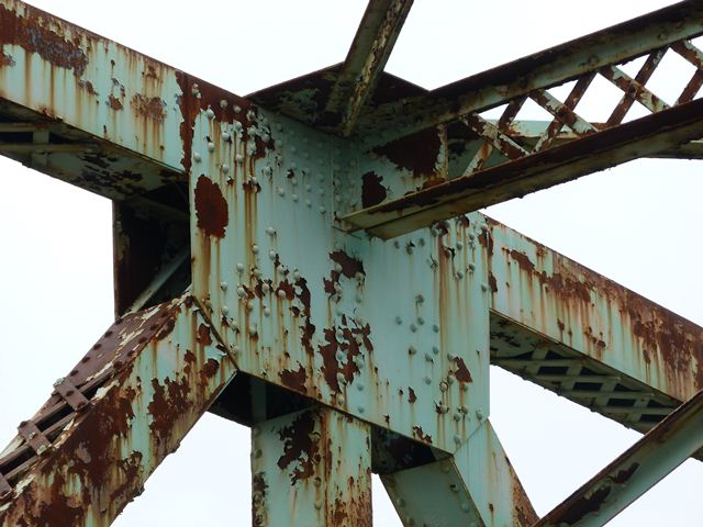
The General Sullivan Bridge has been bypassed by a modern bridge, however was left standing next to its replacement. There was serious concerns that despite this, the bridge was still at risk for demolition. However, a visit to the bridge in 2012 found that a large approach structure had been built to reach the northern end of the bridge, which was disconnected as part of the continuing project to provide a wider vehicular bridge next to the historic bridge. This substantial approach structure accommodates non-motorized traffic. It seems unlikely that the bridge currently faces demolition, if such expense went toward producing this new approach system. There is some cause for continuing concern however, since one of the southern approach spans is signed and partially fenced to limit the number of pedestrians on it, suggesting there is some form of deterioration on this particular span. It is hoped that the bridge will receive whatever repairs are needed to ensure this exceedingly significant historic bridge remains for decades to come.
![]()
Photo Galleries and Videos: General Sullivan Bridge
Structure Overview
Original / Full Size PhotosA collection of overview photos that show the bridge as a whole and general areas of the bridge. This gallery offers photos in the highest available resolution and file size in a touch-friendly popup viewer.
Alternatively, Browse Without Using Viewer
![]()
Structure Details
Original / Full Size PhotosA collection of detail photos that document the parts, construction, and condition of the bridge. This gallery offers photos in the highest available resolution and file size in a touch-friendly popup viewer.
Alternatively, Browse Without Using Viewer
![]()
Structure Overview
Mobile Optimized PhotosA collection of overview photos that show the bridge as a whole and general areas of the bridge. This gallery features data-friendly, fast-loading photos in a touch-friendly popup viewer.
Alternatively, Browse Without Using Viewer
![]()
Structure Details
Mobile Optimized PhotosA collection of detail photos that document the parts, construction, and condition of the bridge. This gallery features data-friendly, fast-loading photos in a touch-friendly popup viewer.
Alternatively, Browse Without Using Viewer
![]()
Maps and Links: General Sullivan Bridge
Access this bridge from the north on Dover Point Road, where there is a small park from where you can both view and walk on the bridge and park your car.
Coordinates (Latitude, Longitude):
Search For Additional Bridge Listings:
Bridgehunter.com: View listed bridges within 0.5 miles (0.8 kilometers) of this bridge.
Bridgehunter.com: View listed bridges within 10 miles (16 kilometers) of this bridge.
Additional Maps:
Google Streetview (If Available)
GeoHack (Additional Links and Coordinates)
Apple Maps (Via DuckDuckGo Search)
Apple Maps (Apple devices only)
Android: Open Location In Your Map or GPS App
Flickr Gallery (Find Nearby Photos)
Wikimedia Commons (Find Nearby Photos)
Directions Via Sygic For Android
Directions Via Sygic For iOS and Android Dolphin Browser
USGS National Map (United States Only)
Historical USGS Topo Maps (United States Only)
Historic Aerials (United States Only)
CalTopo Maps (United States Only)


