We Recommend:
Bach Steel - Experts at historic truss bridge restoration.
BridgeHunter.com Phase 1 is released to the public! - Visit Now
Canal Road Bridge
Six Mile Creek Aqueduct

Primary Photographer(s): Nathan Holth
Bridge Documented: November 8, 2015
Rural: Hunterdon County, New Jersey: United States
1934
12.0 Feet (3.7 Meters)
42.0 Feet (12.8 Meters)
Not Available
3 Main Span(s)
18G0403

View Information About HSR Ratings
Bridge Documentation
View Archived National Bridge Inventory Report - Has Additional Details and Evaluation
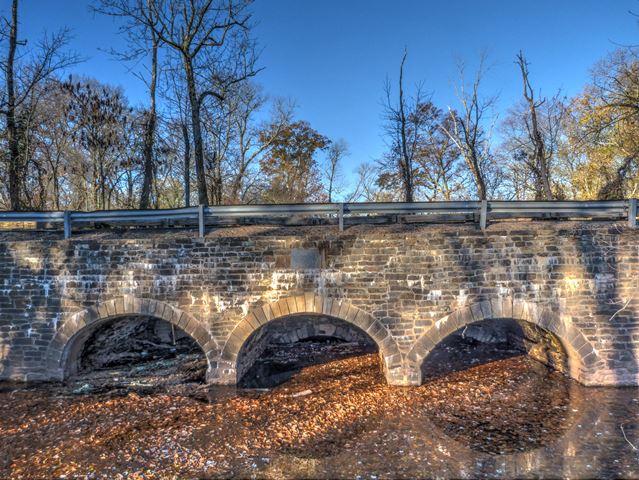
This is a very old stone structure. It was built in 1834 as an aqueduct that carries Six Mile Run under the Delaware and Raritan Canal. At some point the structure was widened by adding a stone arch structure to the east side. The road that parallels the canal passes over this segment. The added stone structure is quite a bit higher in elevation than the original arch. Looking at the barrel of the structure, it is visible further below.
The dimensions given above are what are listed in the National Bridge Inventory. The length of the aqueduct (ie the width of the bridge) is obviously much greater than the roadway width. The roadway width was not listed in the National Bridge Inventory. HistoricBridges.org estimates the overall length of the aqueduct at 135 feet.
Information and Findings From New Jersey's Historic Bridge InventoryDiscussion of Bridge The three-span stone arch was constructed as part of the Delaware and Raritan Canal in 1834. The canal operated until about 1940 and primarily carried Pennsylvania coal to New York. After its closing, the state acquired the canal for a park. In 1984 the aqueduct, which carries the road and the canal/towpath at different levels, was restored. It is one of the largest of at least 16 stone arch structures along the canal. It is listed on the National Register because it carries the canal r-o-w. Discussion of Surrounding Area The bridge is an aqueduct serving to carry both River Road and the neighboring Delaware and Raritan Canal over Six Mile Run. The area is rural with fields and woods. To the north is the 19th-century crossroads village of Blackwells Mills with a restored canal lock tenders house maintained by the Delaware and Raritan Canal State Park. The canal right-of-way is listed in the National Register. Since the structure carries the listed resource, it is interpreted as also being eligible. Bridge Considered Historic By Survey: Yes |
![]()
Photo Galleries and Videos: Canal Road Bridge
Bridge Photo-Documentation
Original / Full Size PhotosA collection of overview and detail photos. This gallery offers photos in the highest available resolution and file size in a touch-friendly popup viewer.
Alternatively, Browse Without Using Viewer
![]()
Bridge Photo-Documentation
Mobile Optimized PhotosA collection of overview and detail photos. This gallery features data-friendly, fast-loading photos in a touch-friendly popup viewer.
Alternatively, Browse Without Using Viewer
![]()
Maps and Links: Canal Road Bridge
Coordinates (Latitude, Longitude):
Search For Additional Bridge Listings:
Bridgehunter.com: View listed bridges within 0.5 miles (0.8 kilometers) of this bridge.
Bridgehunter.com: View listed bridges within 10 miles (16 kilometers) of this bridge.
Additional Maps:
Google Streetview (If Available)
GeoHack (Additional Links and Coordinates)
Apple Maps (Via DuckDuckGo Search)
Apple Maps (Apple devices only)
Android: Open Location In Your Map or GPS App
Flickr Gallery (Find Nearby Photos)
Wikimedia Commons (Find Nearby Photos)
Directions Via Sygic For Android
Directions Via Sygic For iOS and Android Dolphin Browser
USGS National Map (United States Only)
Historical USGS Topo Maps (United States Only)
Historic Aerials (United States Only)
CalTopo Maps (United States Only)

