We Recommend:
Bach Steel - Experts at historic truss bridge restoration.
BridgeHunter.com Phase 1 is released to the public! - Visit Now
Fair Lawn Avenue Bridge

Primary Photographer(s): Nathan Holth
Bridge Documented: September 5, 2019
Paterson and Fair Lawn: Passaic County, New Jersey and Bergen County, New Jersey: United States
1967
134.0 Feet (40.8 Meters)
270.0 Feet (82.3 Meters)
19.4 Feet (5.91 Meters)
2 Main Span(s)
1600009

View Information About HSR Ratings
Bridge Documentation
This bridge no longer exists!
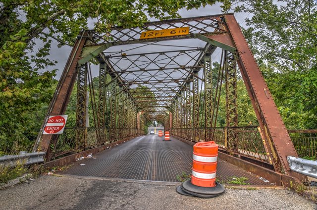
Bridge Status: Demolished in 2021 with replacement planned.This attractive two span pin-connected through truss with a slight skew has been sentenced to the dumpster. Pin-connected truss bridges with a skew are uncommon. The bridge also has a beautiful lattice railing. As of 2019, the bridge had been closed to eastbound traffic with only westbound traffic allowed.
View Archived National Bridge Inventory Report - Has Additional Details and Evaluation
Information and Findings From New Jersey's Historic Bridge InventorySummary The 2-span pin-connected Pratt thru truss bridge supported on concrete abutments and a cutwater pier is a well-preserved example of its type. Aside from impact damage and the 1925 and mid-1960s replacement of the sidewalk brackets and stringers, the span is largely unaltered. The original lattice railings survive. The undocumented bridge was built after the disastrous 1903 flood that claimed most of the bridges in the Paterson area. It is one of 3 significant thru truss bridges in the county. Setting/Context The bridge carries two lanes over the Passaic River at the boundary between Bergen and Passaic counties at a T intersection. The Passaic County side is adjacent to a late-19th century industrial plant now used for chemical production while the Bergen County side is dominated by early-20th century detached homes in the suburban community of Fair Lawn. Physical Description The skewed 2-span pin-connected and riveted Pratt thru truss bridge with a cantilevered sidewalk on the downstream side is supported on concrete abutments with wingwalls and a center cutwater pier. The top chords and inclined end posts are built-up box members with lacing on the underside. The verticals are laced toe-out channels, and the diagonals and bottom chords are stamped eye bars. The span marks the transition from pinned to riveted field connections. The upper panel points are pinned while the lower panel points have pins for the bottom chords and rivets for connecting the floor beams to the verticals. The floor beams are built up and set on the skew. The lattice portal brace has been strengthened by the addition of plate corner braces welded in place in the mid 1960s. One of the most significant features of the bridge is the survival of the handsome lattice railings set inside the truss lines. The railings are accented with rosette bosses. The deck is a modern steel grid deck placed in the mid 1960s. Historical and Technological Significance The well-preserved 2-span pin-connected and riveted Pratt thru truss bridge built in 1905 to replace a span lost in the October, 1903 flood, ranks as the only example of its type in the county. It is also significant in that it marks the transition from pinned to riveted field connections. Its location in an urban area makes its a remarkable survivor form an era when load and traffic needs were much different. Despite some impact damage, the bridge remains in service on a busy intercounty road appearing and functioning much as it did in 1905 when it was completed. It survives as a good representative example of its truss type and fabrication technology (criterion C). The bridge is one of four thru truss spans in the county, and it is the only one that has pin connections. It is a late example of a pinconnected bridge. By 1905 most metal thru truss bridges had riveted field connections. No original plans survive, and the fabricator is not documented in the county engineer's records. The bridge is one of many in Passaic County that were built after the 1903 flood that carried away ten bridges on the section of the Passaic River between the Great Falls in Paterson and Dundee dam in Clifton, about two miles downstream from the falls. Boundary Description and Justification The bridge is individually significant. No significant cultural resources are contiguous to the bridge. Therefore, the boundary is limited to the substructure and superstructure of the span itself. Sources Bibliography: Passaic County Engineer. Bridge File, 9. Minutes Passaic County Board of Chosen Freeholders. 1903-1905. "Flood Damage to Bridges at Paterson, N.J. Engineering News. Vol. L, No. 18 (October 29, 1903), pp. 377-378. Bridge Considered Historic By Survey: Yes |
![]()
Photo Galleries and Videos: Fair Lawn Avenue Bridge
Bridge Photo-Documentation
Original / Full Size PhotosA collection of overview and detail photos. This gallery offers photos in the highest available resolution and file size in a touch-friendly popup viewer.
Alternatively, Browse Without Using Viewer
![]()
Bridge Photo-Documentation
Mobile Optimized PhotosA collection of overview and detail photos. This gallery features data-friendly, fast-loading photos in a touch-friendly popup viewer.
Alternatively, Browse Without Using Viewer
![]()
Maps and Links: Fair Lawn Avenue Bridge
This historic bridge has been demolished. This map is shown for reference purposes only.
Coordinates (Latitude, Longitude):
Search For Additional Bridge Listings:
Bridgehunter.com: View listed bridges within 0.5 miles (0.8 kilometers) of this bridge.
Bridgehunter.com: View listed bridges within 10 miles (16 kilometers) of this bridge.
Additional Maps:
Google Streetview (If Available)
GeoHack (Additional Links and Coordinates)
Apple Maps (Via DuckDuckGo Search)
Apple Maps (Apple devices only)
Android: Open Location In Your Map or GPS App
Flickr Gallery (Find Nearby Photos)
Wikimedia Commons (Find Nearby Photos)
Directions Via Sygic For Android
Directions Via Sygic For iOS and Android Dolphin Browser
USGS National Map (United States Only)
Historical USGS Topo Maps (United States Only)
Historic Aerials (United States Only)
CalTopo Maps (United States Only)

