

View Information About HSR Ratings
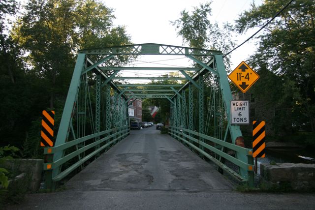
This bridge is intimately nestled within a tiny community called Finesville, and this community looks an image right out of the period this bridge was built. The buildings are positioned very close together: right next to the road and the bridge. It is a truly historical setting that feels much like a museum. The Historic Bridge Inventory found both the bridge and surrounding buildings to be part of a potential historic district. Since that time, the location appears to have indeed been listed as a National Register of Historic Places District, Finesville-Seigletown Historic District (Ref Number 10000892) in 2010. For more information and photos of Finesville visit this website.
The bridge itself stands out as an attractive, variation of a traditional truss bridge type. The bridge is unique on account of its unusual builder, the only documented example of this builder, and the bridge's accompanying unique portal bracing design greatly enhances the aesthetic qualities of the bridge. A historical photograph of the bridge however shows that one unusual and attractive detail of this bridge has been destroyed through alteration. The top of the end posts originally had v-lacing instead of the more typical cover plate. At some point this v-lacing was replaced with cover plate. This alteration does not prevent the bridge from being an important historic bridge, but it does change the appearance of the bridge more than one might expect, and not in a positive manner.
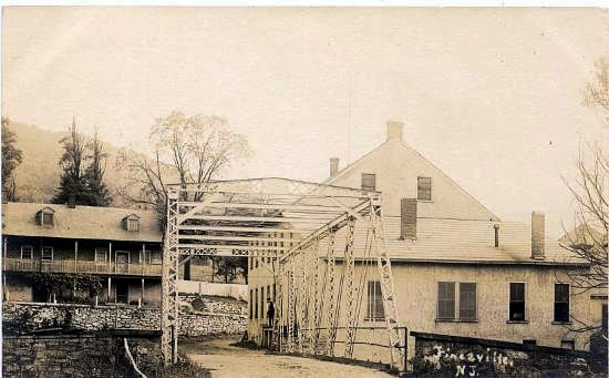
Above: A 1910 photo of the bridge. Note the v-lacing on the top of the end post. Source: Township of Pohatcong
Information and Findings From New Jersey's Historic Bridge InventoryDiscussion of Bridge Summary: The 8-panel pin-connected
Pratt thru truss bridge is supported on random ashlar abutments. The
floorbeams appear to be original. BIBLIOGRAPHY: PHYSICAL DESCRIPTION: The eight-panel full hip Pratt thru-truss bridge has a plaque located at the center of the portals identifying the builder and the Hunterdon County Bridge Committee members. The pin-connected bridge is supported upon stone abutments with retaining walls. The top chords and inclined end posts are box members composed of shallow toe-out channels and cover plates with battens. The bottom chord consists of stamped eyebars, to which reinforcing plates have been welded at the panel points. The vertical members are composed of angles with lacing. The portal braces are also composed of angles with lattice. All but the first interior floor beams are hung from U-bolts. The floor beam hangers are forged loop eye bars that have been reinforced by the addition of bars welded to the top chord and the panel point reinforcing plate. Knee braces have been added at lateral struts and portals. Channel end diagonal braces have been added, and cover plates have been welded to the end posts. According to county records, the corrugated steel deck with asphalt overlay was installed in 1958. Some elements are stamped "Passaic R.M. Co.". HISTORICAL AND TECHNOLOGICAL SIGNIFICANCE: The date of
construction of the 8-panel pin-connected Pratt thru truss bridge is not
documented, but stylistically it appears to be circa 1890. The fairly
well preserved bridge is the only known example of the work of G.M. Rusling, a New Jersey fabricator. In addition to being a good example of
an important bridge type and the work of a local fabricator, the bridge
is located in the village of Mount Joy, a potential National Register
Historic District. It is a contributing resource in that potential
historic district. The first house was reportedly erected in 1829 in
what was a saw mill and iron ore mining area. The village preserves its
historic, 19th- and early-20th century character. The mill dam is
located a few feet upstream from the bridge. Although some alterations
are present, they are predominantly non-intrusive in nature and the
bridge retains its integrity of design. Discussion of Surrounding Area The bridge carries one lane of a narrow street over the Musconetcong River, the border between Hunterdon and Warren Counties. The street is in the center of the well-preserved 19th-century village of Finesville which has National Register-historic district potential. The bridge contributes to the historic character of that potential district. The bridge is a few feet downstream from a mill dam. The mill, now converted to housing, remains. Bridge Considered Historic By Survey: Yes |
![]()
![]()
![]()
Coordinates (Latitude, Longitude):
Search For Additional Bridge Listings:
Bridgehunter.com: View listed bridges within 0.5 miles (0.8 kilometers) of this bridge.
Bridgehunter.com: View listed bridges within 10 miles (16 kilometers) of this bridge.
Additional Maps:
Google Streetview (If Available)
GeoHack (Additional Links and Coordinates)
Apple Maps (Via DuckDuckGo Search)
Apple Maps (Apple devices only)
Android: Open Location In Your Map or GPS App
Flickr Gallery (Find Nearby Photos)
Wikimedia Commons (Find Nearby Photos)
Directions Via Sygic For Android
Directions Via Sygic For iOS and Android Dolphin Browser
USGS National Map (United States Only)
Historical USGS Topo Maps (United States Only)
Historic Aerials (United States Only)
CalTopo Maps (United States Only)

© Copyright 2003-2026, HistoricBridges.org. All Rights Reserved. Disclaimer: HistoricBridges.org is a volunteer group of private citizens. HistoricBridges.org is NOT a government agency, does not represent or work with any governmental agencies, nor is it in any way associated with any government agency or any non-profit organization. While we strive for accuracy in our factual content, HistoricBridges.org offers no guarantee of accuracy. Information is provided "as is" without warranty of any kind, either expressed or implied. Information could include technical inaccuracies or errors of omission. Opinions and commentary are the opinions of the respective HistoricBridges.org member who made them and do not necessarily represent the views of anyone else, including any outside photographers whose images may appear on the page in which the commentary appears. HistoricBridges.org does not bear any responsibility for any consequences resulting from the use of this or any other HistoricBridges.org information. Owners and users of bridges have the responsibility of correctly following all applicable laws, rules, and regulations, regardless of any HistoricBridges.org information.
![]()