

View Information About HSR Ratings
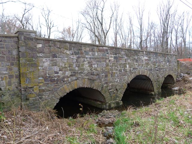
This bridge was just a short distance from an old metal truss bridge that had been damaged by an overweight truck and was demolished by the time HistoricBridges.org did a field visit. As part of that project this bridge was also replaced. This bridge was altered, and it is not clear if it was a true stone arch bridge or was a concrete arch with stone facing. If it was a concrete bridge, the 1941 date might be when the bridge was originally built, however if it was a true stone arch bridge the 1941 date likely refers to the alteration date.
One of the parapet walls had already been demolished when this bridge was photographed. The plaque was also removed.
|
Plaque Text 1941C. Y. HAMP DIR. F. R. HOFFMAN S. L. BODINE F. BOHREN ENG. |
Information and Findings From New Jersey's Historic Bridge InventoryDiscussion of Bridge According to county records, the now corrugated steel-lined arches of the 3-span bridge are concrete lined. The original date of construction is not known, nor is it known if the spans are stone or concrete arches. 1941 may well be the date of reconstruction. The structure, which has larger arches flanking the central arch, is finished with coursed ashlar spandrel walls and ringstones. The undocumented span is not known to be historically or technologically distinguished. No plans survive. Discussion of Surrounding Area The bridge carries two lanes of a moderately traveled county road over a minor stream. The setting is wooded and rural with sparse housing. A marker identifies the adjacent structure as the 1830 tavern built to replace the 1750 log Kingswood Tavern located on the same site. The bridge is contiguous to a pony truss span (1000011) that crosses the main channel of the stream. Bridge Considered Historic By Survey: No |
![]()
![]()
![]()
This historic bridge has been demolished. This map is shown for reference purposes only.
Coordinates (Latitude, Longitude):
Search For Additional Bridge Listings:
Bridgehunter.com: View listed bridges within 0.5 miles (0.8 kilometers) of this bridge.
Bridgehunter.com: View listed bridges within 10 miles (16 kilometers) of this bridge.
Additional Maps:
Google Streetview (If Available)
GeoHack (Additional Links and Coordinates)
Apple Maps (Via DuckDuckGo Search)
Apple Maps (Apple devices only)
Android: Open Location In Your Map or GPS App
Flickr Gallery (Find Nearby Photos)
Wikimedia Commons (Find Nearby Photos)
Directions Via Sygic For Android
Directions Via Sygic For iOS and Android Dolphin Browser
USGS National Map (United States Only)
Historical USGS Topo Maps (United States Only)
Historic Aerials (United States Only)
CalTopo Maps (United States Only)

© Copyright 2003-2026, HistoricBridges.org. All Rights Reserved. Disclaimer: HistoricBridges.org is a volunteer group of private citizens. HistoricBridges.org is NOT a government agency, does not represent or work with any governmental agencies, nor is it in any way associated with any government agency or any non-profit organization. While we strive for accuracy in our factual content, HistoricBridges.org offers no guarantee of accuracy. Information is provided "as is" without warranty of any kind, either expressed or implied. Information could include technical inaccuracies or errors of omission. Opinions and commentary are the opinions of the respective HistoricBridges.org member who made them and do not necessarily represent the views of anyone else, including any outside photographers whose images may appear on the page in which the commentary appears. HistoricBridges.org does not bear any responsibility for any consequences resulting from the use of this or any other HistoricBridges.org information. Owners and users of bridges have the responsibility of correctly following all applicable laws, rules, and regulations, regardless of any HistoricBridges.org information.
![]()