

View Information About HSR Ratings
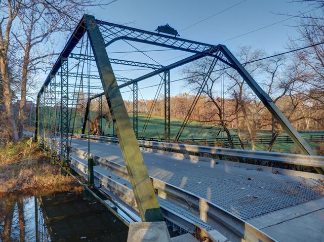
This is an excellent example of a Pratt truss by the notable King Bridge Company. It retains good historic integrity, and follows the typical detailing of its builder including plaques.
Information and Findings From New Jersey's Historic Bridge InventorySummary One of two well-preserved King Iron Bridge Co. pin-connected Pratt thru trusses in Mercer County, the Mine Road bridge is three years later than Bear Tavern Road (1100060), but is nevertheless an important example of its type. Supported on unaltered ashlar abutments, the 5-panel bridge has few visible repairs. The floor beams may not be original. It is one of four thru truss bridges in the county and ranks as the second oldest and one of the least altered. Setting/Context On a rural two-lane road, the one-lane bridge crosses a small stream. The bridge enjoys integrity of setting in a rural area dominated by working farms. It is located in the sparsely developed northwestern portion of the county east of busy NJ 31. Physical Description The seven panel half-hip pin-connected Pratt thru truss with a steel grate deck installed in 1976 has true hangers that twist 90 degrees out of phase and then pick up the end floor beams. The bearings rest on ashlar abutments. The inclined end posts and upper chord are built-up members composed of shallow channels with a face plate. The same dimension channels are used for the laced verticals. Diagonals (of bar stock with loop-forged eyes) and counters (rods) are fitted with turnbuckles for tuning the bridge, and the bottom chord is die-forged eyebars. The originality of the rolled I beam floor beams is not known, but it is believed that they are not original. They are cut back in section for the suspenders and large square nuts that do appear to be original. The floor beams are fitted with the original brackets for the lateral bracing. The portal struts have a lattice bracing, as does the sway bracing, and each end carries a King Iron Bridge and Manufacturing Co. plaque. The lateral bracing is connected to a crimped bracket that connects at the upper panel point pins. A few welded repairs to the verticals at the panel points are visible, but otherwise the bridge is very well preserved. The modern beam guide rail is attached to the verticals by bolts. Historical and Technological Significance The well-preserved 102'-long pin-connected thru truss by the King Iron Bridge and Manufacturing Company of Cleveland, Ohio was erected in 1885, according to its plaque, and is one of two well preserved King thru trusses from the 1880s in Mercer County. The Mine Road bridge, the longer, heavier, and newer of the two, as well as its counterpart on Bear Tavern Road (1100060), are of statewide importance as early examples of a historic bridge type. They are also examples of bridges fabricated by one of the largest and most successful late-19th century manufacturers. The two Mercer County bridges are believed to be the only documented King Iron Bridge and Manufacturing Company in the state. Technologically they reflect early metal truss bridge construction details, such as the true floor beam hangers, the lateral bracing connections, and the prong-like floor beam connectors at the verticals. The bridge is an early and very well preserved example of its type. The King Iron Bridge and Manufacturing Company was established by Zenas King in Cleveland about 1860. Learning the bridge selling business in the 1850s as a salesman representing the Moseley Bridge Company (a patented tubular bowstring), King patented his own tubular bowsting bridge that was to be the company's chief product through the 1870s, and he successfully marketed it nationally through a network of regional representatives. He published catalogues in 1875 and 1884 as well as annual reports. As the market moved away from the light bowstring truss about 1880, he diversified his product line to include the what was becoming standard thru and pony trusses. The King company was one of the largest and most prolific bridge fabricating firms in the country yet only approximately half a dozen documented examples of the firm's work survive in New Jersey. While the company remained an active, viable concern for about a decade after the founder's death in 1892, it was not a regional force in this century. The King Iron Bridge and Manufacturing Company, known as the King Bridge Company after 1892, represents, in addition to period engineering and technology, the manner in which iron and early steel bridges were marketed in this country. The fabricator served as both engineer and builder. That practice was to disappear with the rise of the consulting engineer and the professionally trained county engineer in the early years of this century. Sources Simmons, David A. "Bridge Building on a National Scale: The King Iron Bridge and Manufacturing Company." The Journal of the Society for Industrial Archaeology. Vol. 15, No. 2, 1989. Mercer County Engineers Office. Transfer File 230.3. Bridge Considered Historic By Survey: Yes |
![]()
![]()
![]()
Coordinates (Latitude, Longitude):
Search For Additional Bridge Listings:
Bridgehunter.com: View listed bridges within 0.5 miles (0.8 kilometers) of this bridge.
Bridgehunter.com: View listed bridges within 10 miles (16 kilometers) of this bridge.
Additional Maps:
Google Streetview (If Available)
GeoHack (Additional Links and Coordinates)
Apple Maps (Via DuckDuckGo Search)
Apple Maps (Apple devices only)
Android: Open Location In Your Map or GPS App
Flickr Gallery (Find Nearby Photos)
Wikimedia Commons (Find Nearby Photos)
Directions Via Sygic For Android
Directions Via Sygic For iOS and Android Dolphin Browser
USGS National Map (United States Only)
Historical USGS Topo Maps (United States Only)
Historic Aerials (United States Only)
CalTopo Maps (United States Only)

© Copyright 2003-2026, HistoricBridges.org. All Rights Reserved. Disclaimer: HistoricBridges.org is a volunteer group of private citizens. HistoricBridges.org is NOT a government agency, does not represent or work with any governmental agencies, nor is it in any way associated with any government agency or any non-profit organization. While we strive for accuracy in our factual content, HistoricBridges.org offers no guarantee of accuracy. Information is provided "as is" without warranty of any kind, either expressed or implied. Information could include technical inaccuracies or errors of omission. Opinions and commentary are the opinions of the respective HistoricBridges.org member who made them and do not necessarily represent the views of anyone else, including any outside photographers whose images may appear on the page in which the commentary appears. HistoricBridges.org does not bear any responsibility for any consequences resulting from the use of this or any other HistoricBridges.org information. Owners and users of bridges have the responsibility of correctly following all applicable laws, rules, and regulations, regardless of any HistoricBridges.org information.
![]()