

View Information About HSR Ratings
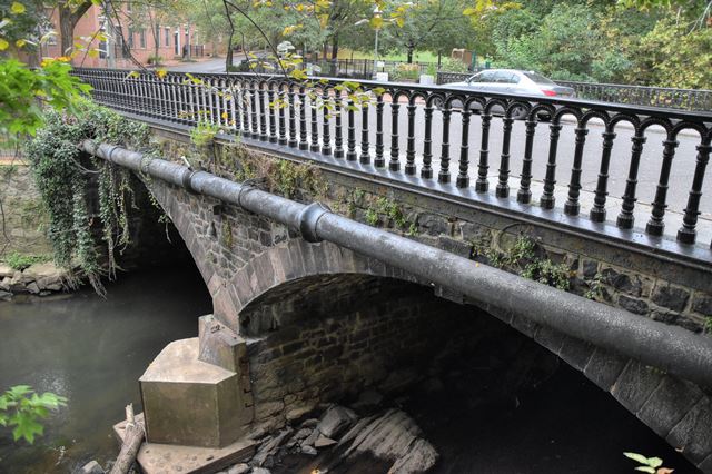
This stone arch bridge is one of the only known bridges in the country to feature cast iron railings. The Historic Bridge Inventory claims that Henry E. Finch was the architect for the bridge, yet the railing has a casting that states that Robert P. Gallagher was the architect. James D. Field fabricated the iron railings for the bridge, while the bridge contractor was John. H. Silvers. The historic bridge contributes to the Mill Hill Historic District.
Information and Findings From New Jersey's Historic Bridge InventorySummary The handsome 2-span rubble-coursed stone arch bridge with its original cast iron balustrade, the only known example of its type in the area, was designed by Trenton architect Henry E. Finch. He also did the 1869 S. Clinton St. stone arch bridge. The well-preserved bridge with voussoirs contributes to the architectural significance of the Mill Hill Historic District. The 1977 NR nomination does not include an inventory, but the bridge is mentioned in the text as a contributing resource. It is also individually significant based on its type, completeness, and association with architect Finch. The bridge is individually eligible for listing in the National Register under Criterion C and is a contributing element to the Mill Hill Historic District. Setting/Context The bridge carries a city street over Assunpink Creek in an urban, mid-19th century mixed use neighborhood in downtown Trenton. The surroundings are dominated by row houses that are being restored. Some modern, incompatible redevelopment has occurred to the north and east of the bridge. The span contributes greatly to the historic character of area. Bridge Considered Historic By Survey: Yes |
![]()
![]()
![]()
Coordinates (Latitude, Longitude):
Search For Additional Bridge Listings:
Bridgehunter.com: View listed bridges within 0.5 miles (0.8 kilometers) of this bridge.
Bridgehunter.com: View listed bridges within 10 miles (16 kilometers) of this bridge.
Additional Maps:
Google Streetview (If Available)
GeoHack (Additional Links and Coordinates)
Apple Maps (Via DuckDuckGo Search)
Apple Maps (Apple devices only)
Android: Open Location In Your Map or GPS App
Flickr Gallery (Find Nearby Photos)
Wikimedia Commons (Find Nearby Photos)
Directions Via Sygic For Android
Directions Via Sygic For iOS and Android Dolphin Browser
USGS National Map (United States Only)
Historical USGS Topo Maps (United States Only)
Historic Aerials (United States Only)
CalTopo Maps (United States Only)

© Copyright 2003-2026, HistoricBridges.org. All Rights Reserved. Disclaimer: HistoricBridges.org is a volunteer group of private citizens. HistoricBridges.org is NOT a government agency, does not represent or work with any governmental agencies, nor is it in any way associated with any government agency or any non-profit organization. While we strive for accuracy in our factual content, HistoricBridges.org offers no guarantee of accuracy. Information is provided "as is" without warranty of any kind, either expressed or implied. Information could include technical inaccuracies or errors of omission. Opinions and commentary are the opinions of the respective HistoricBridges.org member who made them and do not necessarily represent the views of anyone else, including any outside photographers whose images may appear on the page in which the commentary appears. HistoricBridges.org does not bear any responsibility for any consequences resulting from the use of this or any other HistoricBridges.org information. Owners and users of bridges have the responsibility of correctly following all applicable laws, rules, and regulations, regardless of any HistoricBridges.org information.
![]()