

View Information About HSR Ratings
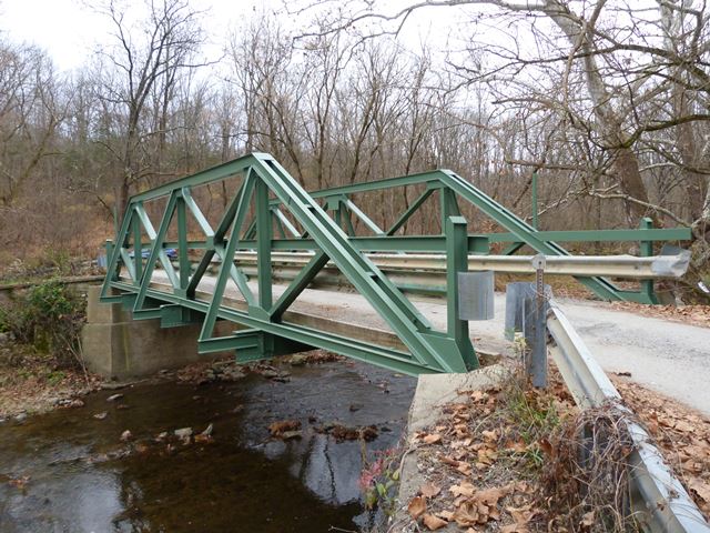
Built in 1938, this bridge is a relatively early example of a welded truss bridge. An interesting detail on this bridge however is that the floorbeams are reused from some other pin-connected truss bridge, perhaps the previous one at this very location, or perhaps another one entirely. The salvaged and reused riveted floor beams have two large holes visible in the flanges at each end of the beams, this was for the u-bolt hangers of the previous pin-connected truss bridge that they were a part of. Outriggers have been welded to the ends of these floor beams.
Information and Findings From New Jersey's Historic Bridge InventoryDiscussion of Bridge The one-span welded pony truss bridge is set on stone abutments, one of them with a later concrete buttress. The truss is composed of rolled I-sections welded together with gusset plates. The floorbeams are built-up with flange angles riveted to the web plates. Rolled stringers support a timber deck. The bridge replaces a pin-connected Pratt pony truss. It is one of three welded pony trusses crossing the same creek in Pohatcong Township. Although the bridge conveys the concept of the truss design, it no longer retains integrity of materials or design and is not individually eligible for listing in the National Register of Historic Places, nor does it currently contribute to an identified historic district. Discussion of Surrounding Area The bridge is located in a wooded area with scattered residences. The one-lane bridge carries a winding road over a stream. Bridge Considered Historic By Survey: No |
![]()
![]()
![]()
Coordinates (Latitude, Longitude):
Search For Additional Bridge Listings:
Bridgehunter.com: View listed bridges within 0.5 miles (0.8 kilometers) of this bridge.
Bridgehunter.com: View listed bridges within 10 miles (16 kilometers) of this bridge.
Additional Maps:
Google Streetview (If Available)
GeoHack (Additional Links and Coordinates)
Apple Maps (Via DuckDuckGo Search)
Apple Maps (Apple devices only)
Android: Open Location In Your Map or GPS App
Flickr Gallery (Find Nearby Photos)
Wikimedia Commons (Find Nearby Photos)
Directions Via Sygic For Android
Directions Via Sygic For iOS and Android Dolphin Browser
USGS National Map (United States Only)
Historical USGS Topo Maps (United States Only)
Historic Aerials (United States Only)
CalTopo Maps (United States Only)

© Copyright 2003-2026, HistoricBridges.org. All Rights Reserved. Disclaimer: HistoricBridges.org is a volunteer group of private citizens. HistoricBridges.org is NOT a government agency, does not represent or work with any governmental agencies, nor is it in any way associated with any government agency or any non-profit organization. While we strive for accuracy in our factual content, HistoricBridges.org offers no guarantee of accuracy. Information is provided "as is" without warranty of any kind, either expressed or implied. Information could include technical inaccuracies or errors of omission. Opinions and commentary are the opinions of the respective HistoricBridges.org member who made them and do not necessarily represent the views of anyone else, including any outside photographers whose images may appear on the page in which the commentary appears. HistoricBridges.org does not bear any responsibility for any consequences resulting from the use of this or any other HistoricBridges.org information. Owners and users of bridges have the responsibility of correctly following all applicable laws, rules, and regulations, regardless of any HistoricBridges.org information.
![]()