

View Information About HSR Ratings
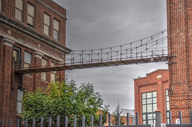
Although it does not appear to be original materials, it is believed this bridge represents the original intent of John A. Roebling's Sons to display a tiny suspension bridge as an integral part of their wire works, which was listed on HAER documents as a "Test Bridge". Also included in the photo gallery are general photos of the wire works, much of which has been adaptively reused, and remains a rare intact collection of buildings from a major bridge company of the past.
Length given is an estimate.
HAER provides the following summary:
In 1848 John A. Roebling purchased a 25 acre site along the Delaware & Raritan Canal in Chambersburg (now a part of Trenton) for his wire rope business. Roebling designed the buildings and machinery and directed the company until his death in 1869, when his three sons Washington, Ferdinand, and Charles took over. Besides designing, building, and supplying cable and wire rope for important suspension bridges from the 1860s to the 1930s, the company manufactured wire rope and related products for shipping, mining, construction (including the Panama Canal), electrical power transmission, cable cars, tramways, aircraft, submarine netting, musical instruments, elevators, logging and oil drilling. By World War I, the factory was the largest wire rope plant in the world and the company grew considerably in response to steadily increasing demands for its products.
This bridge is tagged with the following special condition(s): Unorganized Photos
![]()
![]()
![]()
Coordinates (Latitude, Longitude):
Search For Additional Bridge Listings:
Bridgehunter.com: View listed bridges within 0.5 miles (0.8 kilometers) of this bridge.
Bridgehunter.com: View listed bridges within 10 miles (16 kilometers) of this bridge.
Additional Maps:
Google Streetview (If Available)
GeoHack (Additional Links and Coordinates)
Apple Maps (Via DuckDuckGo Search)
Apple Maps (Apple devices only)
Android: Open Location In Your Map or GPS App
Flickr Gallery (Find Nearby Photos)
Wikimedia Commons (Find Nearby Photos)
Directions Via Sygic For Android
Directions Via Sygic For iOS and Android Dolphin Browser
USGS National Map (United States Only)
Historical USGS Topo Maps (United States Only)
Historic Aerials (United States Only)
CalTopo Maps (United States Only)

© Copyright 2003-2026, HistoricBridges.org. All Rights Reserved. Disclaimer: HistoricBridges.org is a volunteer group of private citizens. HistoricBridges.org is NOT a government agency, does not represent or work with any governmental agencies, nor is it in any way associated with any government agency or any non-profit organization. While we strive for accuracy in our factual content, HistoricBridges.org offers no guarantee of accuracy. Information is provided "as is" without warranty of any kind, either expressed or implied. Information could include technical inaccuracies or errors of omission. Opinions and commentary are the opinions of the respective HistoricBridges.org member who made them and do not necessarily represent the views of anyone else, including any outside photographers whose images may appear on the page in which the commentary appears. HistoricBridges.org does not bear any responsibility for any consequences resulting from the use of this or any other HistoricBridges.org information. Owners and users of bridges have the responsibility of correctly following all applicable laws, rules, and regulations, regardless of any HistoricBridges.org information.
![]()