

View Information About HSR Ratings
This bascule bridge is noted for its arched deck plate girder approach spans, which are encased in concrete, although the lower chords have had the concrete removed. It is also noted for its main bascule span, which is a fixed trunnion, but designed according to a patented design.
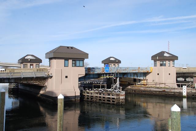
Information and Findings From New Jersey's Historic Bridge InventorySummary The 10-span haunched deck girder bridge has a double-leaf bascule with fixed concrete counterweights main span. The approach spans are encased. The bascule is one of over 12 in southeast New Jersey from the 1920s and 1930s designed by the noted firm of Ash Howard Needles and Tammen. A representative example of the type, the span is altered with new reducers, motors, controls, locks, electrical systems, and remodeled operators houses. The alterations make the span less significant than others. Setting/Context The movable bridge carries 4 lanes of traffic and two sidewalks over a navigable portion of the Shark River. The bridge is located between the beach resort towns of Avon-by-the-Sea and Belmar. The area is heavily developed with marinas, restaurants, stores, and late-19th to late-20th century seasonal and year-round homes and apartments. Physical Description The main span of the 860'-long 10-span bridge is a 90'-long double-leaf bascule. The two approach spans to the south and seven to the north are haunched deck multi girders on a concrete substructure. The bridge is finished with standard-design concrete balustrades, and the enclosures on the movable leafs are the same style executed in metal. Operators/machinery houses are set at each corner of the movable leafs. They have been remodeled with oversized metal pyramidal hip roofs and new metal windows and doors. The movable leafs are composed of four haunched girders with floor beams and an open steel grid deck. The bascule leafs have fixed counterweights at the tail ends. Each leaf is operated by a pinion that engages a rack affixed to the outside of the fascia girders. While the trunnions and trunnion towers are original, the motors, controls, electrical systems, back up operation, primary reducers, motor brakes, machinery brakes, and locks are all new. The secondary reducers are original as are the racks and pinions. The operators' and equipment houses have also been redone. Historical and Technological Significance The 1932 NJ 71 bascule bridge over the Shark River is an altered example of the most common post-1925 movable bridge type in southeast New Jersey. It is one of over 12 patented Ash-Howard-Needles & Tammen movable bridges built between 1928 and 1941 in the Monmouth-Cape May County region. Many of the examples survive in unaltered condition. The Shark River bridge retains its integrity of function and some original or in kind replacement fabric. But, in comparison, this span is not a well preserved example and is thus less technologically significant than others of the same design built in the same time period. The patent related to the bridge addresses the design of the trunnion tower. More complete examples of bridges of the same design in Monmouth County are Oceanic Bridge over the Navesink River (1300S31, 1939, Middletown Twp.) and NJ 36 over the Navesink River (1315150, 1932, Highlands Borough). Bridge Considered Historic By Survey: No |
![]()
![]()
![]()
Coordinates (Latitude, Longitude):
Search For Additional Bridge Listings:
Bridgehunter.com: View listed bridges within 0.5 miles (0.8 kilometers) of this bridge.
Bridgehunter.com: View listed bridges within 10 miles (16 kilometers) of this bridge.
Additional Maps:
Google Streetview (If Available)
GeoHack (Additional Links and Coordinates)
Apple Maps (Via DuckDuckGo Search)
Apple Maps (Apple devices only)
Android: Open Location In Your Map or GPS App
Flickr Gallery (Find Nearby Photos)
Wikimedia Commons (Find Nearby Photos)
Directions Via Sygic For Android
Directions Via Sygic For iOS and Android Dolphin Browser
USGS National Map (United States Only)
Historical USGS Topo Maps (United States Only)
Historic Aerials (United States Only)
CalTopo Maps (United States Only)

© Copyright 2003-2026, HistoricBridges.org. All Rights Reserved. Disclaimer: HistoricBridges.org is a volunteer group of private citizens. HistoricBridges.org is NOT a government agency, does not represent or work with any governmental agencies, nor is it in any way associated with any government agency or any non-profit organization. While we strive for accuracy in our factual content, HistoricBridges.org offers no guarantee of accuracy. Information is provided "as is" without warranty of any kind, either expressed or implied. Information could include technical inaccuracies or errors of omission. Opinions and commentary are the opinions of the respective HistoricBridges.org member who made them and do not necessarily represent the views of anyone else, including any outside photographers whose images may appear on the page in which the commentary appears. HistoricBridges.org does not bear any responsibility for any consequences resulting from the use of this or any other HistoricBridges.org information. Owners and users of bridges have the responsibility of correctly following all applicable laws, rules, and regulations, regardless of any HistoricBridges.org information.
![]()