We Recommend:
Bach Steel - Experts at historic truss bridge restoration.
BridgeHunter.com Phase 1 is released to the public! - Visit Now
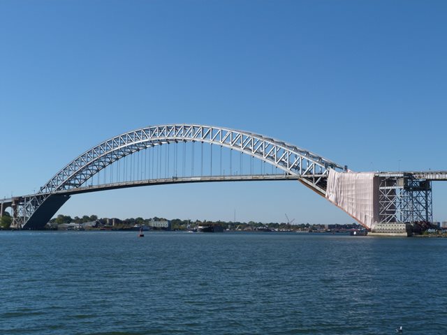
Bayonne Bridge
Primary Photographer(s): Nathan Holth
Bridge Documented: October 19-20, 2013 and September 3, 2019
Bayonne and New York: Hudson County, New Jersey and Staten Island, New York: United States
Metal Two-Hinged Braced Ribbed Through Arch, Fixed and Approach Spans: Metal Deck Girder, Fixed
1931 By Builder/Contractor: American Bridge Company of New York, New York and Engineer/Design: Othmar Ammann
2014
1,675.0 Feet (510.5 Meters)
6,695.0 Feet (2040.6 Meters)
40 Feet (12.19 Meters)
1 Main Span(s) and 72 Approach Span(s)
5523040

View Information About HSR Ratings
Bridge Documentation
Bridge Status: This bridge was significantly altered (after documentation by HistoricBridges.org) as part of a project to raise the roadway/deck of the bridge for boats!
View Archived National Bridge Inventory Report - Has Additional Details and Evaluation
View Historic American Engineering Record (HAER) Documentation For This Bridge
HAER Data Pages, PDF
View Section 106 Documentation For The "Raise the Roadway" Project
View A Biography of Othmar Ammann
View A Port Authority Book About The Bayonne Bridge
View A Historical Book About The Bayonne Bridge
View A Historical Report About This Bridge's Construction
View Historical Article About This Bridge
History and Significance

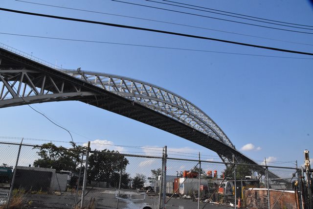
This bridge is nationally significant as one of the most noteworthy steel arch bridges in the United States. It was completed at the same time as the Sydney Harbor Bridge, but since it was a couple feet longer than Sydney Harbor, the Bayonne Bridge claimed the title of longest arch span in the world, a record it held for decades until 1977 when the New River Bridge in West Virginia was completed.
Discussion and Commentary About The "Raise the Roadway" Project
This bridge ran into trouble when project to enlarge the Panama Canal took place. This project in turn will increase the size of container ships which pass through the canal, with many of these ships moving on to destinations like the ports in New Jersey which can only be accessed by passing under the Bayonne Bridge. These newer, larger ships (called New Panamax ships) will be so tall that they will not fit under the as-built Bayonne Bridge.
Since making money is the essential goal in life, no amount of historic significance or beauty in the Bayonne Bridge would make New Jersey turn away the billions of dollars that would be lost if the obstruction to the larger ships was not addressed. As such, normally, this scenario would be a death sentence for a historic bridge. However, a unique project was developed that raises the roadway and deck of the bridge to the height needed for the larger ships, but also retains a portion of the original historic bridge, specifically the record-breaking steel arch structure.

Given the clearance problem that this bridge faces, the "Raise the Roadway" project is about the best that could be hoped for. The project is far preferable to the alternative which would have been total demolition and replacement with a hideously ugly modern bridge, resulting in the destruction of a nationally significant arch structure. This project avoids this horrible fate. It will also retain the record-breaking portion of the bridge, which is the steel arch. However, the fact remains that this project will severely alter the bridge and result in the loss of absolutely every bit of the original bridge with the exception of the steel arch structure. All approach span superstructures (riveted plate girder and concrete t-beams) will be demolished and replaced with modern pre-cast box segments, which will look similar to modern freeway structures. All original concrete piers will be demolished and replaced. This project will also will vastly alter the visual appearance of the main span. In particular, the experience of driving over the bridge will be a lot less interesting, since the arch will only rise above the roadway for a short distance, and it won't rise so dramatically above the roadway.
In short, this project will have a devastating effect on the historic integrity of the bridge, but is still a lot better then demolishing and replacing the bridge.
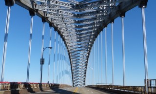
Public information and transparency was very poor for this project. Absolutely no useful information was provided on the Port Authority website regarding the construction timeline. Here in the 21st Century, any time a bridge project of this scale is completed, a detailed, frequently updated construction timeline should be provided online. None of this was made available online. As a result, the sidewalk to this bridge was abruptly closed to pedestrians with no reasonable prior notice made. Additionally, construction work began without reasonable notice made online. As such, HistoricBridges.org had to make an emergency trip to photograph the bridge in October, and by this time was unable to walk on the sidewalk, and had photos obstructed by paint containment. Despite these problems, HistoricBridges.org was still able to gather a rather thorough photo-documentation of this bridge which is intended to convey the appearance and design of the bridge prior to alteration. Below is a photo of the bridge following completion of the project showing the raised deck.
This bridge is tagged with the following special condition(s): Unorganized Photos
![]()
Photo Galleries and Videos: Bayonne Bridge
Structure Overview
Original / Full Size PhotosA collection of overview photos that show the bridge as a whole and general areas of the bridge. This gallery offers photos in the highest available resolution and file size in a touch-friendly popup viewer.
Alternatively, Browse Without Using Viewer
![]()
Structure Details
Original / Full Size PhotosA collection of detail photos that document the parts, construction, and condition of the bridge. This gallery offers photos in the highest available resolution and file size in a touch-friendly popup viewer.
Alternatively, Browse Without Using Viewer
![]()
Crossing The Bridge
Original / Full Size PhotosA series of photos taken with a high resolution, wide angle GoPro camera showing the experiance of driving over the bridge. This gallery offers photos in the highest available resolution and file size in a touch-friendly popup viewer.
Alternatively, Browse Without Using Viewer
![]()
Structure Overview
Mobile Optimized PhotosA collection of overview photos that show the bridge as a whole and general areas of the bridge. This gallery features data-friendly, fast-loading photos in a touch-friendly popup viewer.
Alternatively, Browse Without Using Viewer
![]()
Structure Details
Mobile Optimized PhotosA collection of detail photos that document the parts, construction, and condition of the bridge. This gallery features data-friendly, fast-loading photos in a touch-friendly popup viewer.
Alternatively, Browse Without Using Viewer
![]()
Crossing The Bridge
Mobile Optimized PhotosA series of photos taken with a high resolution, wide angle GoPro camera showing the experiance of driving over the bridge. This gallery features data-friendly, fast-loading photos in a touch-friendly popup viewer.
Alternatively, Browse Without Using Viewer
![]()
CarCam: Southbound Crossing
Full Motion VideoNote: The downloadable high quality version of this video (available on the video page) is well worth the download since it offers excellent 1080 HD detail and is vastly more impressive than the compressed streaming video. Streaming video of the bridge. Also includes a higher quality downloadable video for greater clarity or offline viewing.
![]()
2019 Additional Unorganized Photos
Original / Full Size PhotosA supplemental collection of photos after the bridge's major rehabilitation that are from additional visit(s) to the bridge and have not been organized or captioned. This gallery offers photos in the highest available resolution and file size in a touch-friendly popup viewer.
Alternatively, Browse Without Using Viewer
![]()
2019 Additional Unorganized Photos
Mobile Optimized PhotosA supplemental collection of photos after the bridge's major rehabilitation that are from additional visit(s) to the bridge and have not been organized or captioned. This gallery features data-friendly, fast-loading photos in a touch-friendly popup viewer.
Alternatively, Browse Without Using Viewer
![]()
Maps and Links: Bayonne Bridge
Coordinates (Latitude, Longitude):
Search For Additional Bridge Listings:
Bridgehunter.com: View listed bridges within 0.5 miles (0.8 kilometers) of this bridge.
Bridgehunter.com: View listed bridges within 10 miles (16 kilometers) of this bridge.
Additional Maps:
Google Streetview (If Available)
GeoHack (Additional Links and Coordinates)
Apple Maps (Via DuckDuckGo Search)
Apple Maps (Apple devices only)
Android: Open Location In Your Map or GPS App
Flickr Gallery (Find Nearby Photos)
Wikimedia Commons (Find Nearby Photos)
Directions Via Sygic For Android
Directions Via Sygic For iOS and Android Dolphin Browser
USGS National Map (United States Only)
Historical USGS Topo Maps (United States Only)
Historic Aerials (United States Only)
CalTopo Maps (United States Only)


