

View Information About HSR Ratings
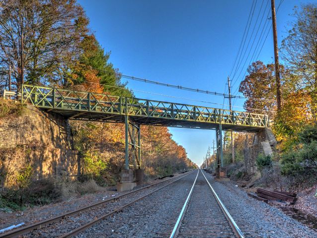
Featuring rare Howe trusses built in 1889, this bridge also makes an early use of riveted connections. The steel bents it rests on were largely reconstructed in 1914.
Information and Findings From New Jersey's Historic Bridge InventorySummary The rivet-connected skewed 3-span Howe pony truss with counters overpass on ashlar abutments and 1914 steel bents is an example of an uncommon truss type. It is an unconventional design with small spacer panels added to each truss to compensate for the skew. The floor beams are perpendicular to the road. Even though all but a few of the built-up floor beams and the flooring system have been replaced, the 1889 bridge survives as a good example and unusual example of its type. Setting/Context The narrow bridge carries one lane of traffic over 2 active tracks of ConRail's main freight line known as the New York Branch. The right-ofway was developed by the Reading Railroad in the mid-1870s. It is located in a sparsely developed rural portion of the county in an area known as Skillman, location of the state's "epileptic village." A station was located on the south side of the bridge. When it was removed is not known, but it is depicted on a 1955 county map. Physical Description The skewed three-span rivet-connected Howe pony truss bridge is supported on ashlar abutments and metal bents composed of toe-out angles. The lateral bracing on the bents was added in 1914. A Howe truss works on the opposite principle of the more common Pratt truss. The verticals are in tension, and the diagonals and counters are the compression members. The chords, verticals, and diagonals are composed of toe-out angles while the counters are dimensioned plate. The original floor beams, which have been replaced at least twice, were built up. The floor beams are perpendicular to the roadway, not the abutments. The most unusual design detail of the trusses is the use of a small panel at either end of each truss which allowed for equal sizing of each pair of skewed trusses. The bridge has been strengthened with welded knee braces on the inside of the trusses and plate welded to the top chord. The stringers and flooring were originally wood, but they have been replaced with steel stringers and an asphalt wearing surface. A modern beam guard rail protects the inner face of the trusses. Historical and Technological Significance The Howe pony truss bridge was designed by the Philadelphia & Reading Railroad Chief Engineer's Office in 1889. In addition to being one of the few documented example of a Howe pony truss bridge in the state, it ranks as the oldest railroad-related span in Somerset County. Why a Howe truss was used is not documented, but it may relate to the decision to reuse the existing substructure which divided the bridge into three spans. The use of the small panels at the end of each truss in order keep each pair of trusses the same length is also an unusual design detail. In 1914 the bracing between the bent posts was added as were the concrete piers, and in 1982 most of the floor beams and stringers were replaced. Despite its over 100 years of active service, the bridge is extremely well preserved and ranks as one of the distinctive pony truss spans in the state. The bridge was constructed for the Philadelphia and Reading Railroad (Reading) at Skillman, site of the state's epileptic village. A nonextant station was located to the southwest of the bridge. The rail right-of-way was chartered in 1870 and built as the Delaware & Bound Brook Railroad by the Central Railroad of New Jersey in 1873-1875 as an alternative double-track route between New York and Philadelphia. The line was acquired by the Reading Railroad, and was used for both freight and passenger service until the 1970s when the line went bankrupt. The right-of-way passed to Conrail which found it useful for freight service displaced from Amtrak's Northeast Corridor which is the old Camden & Amboy (Pennsylvania Railroad after 1873) route. The Skillman Road overpass is also one of the oldest grade crossing elimination bridges in the region. This is at least the second bridge at the crossing. Boundary Description and Justification The bridge is evaluated as individually distinguished for its technological significance. It is adjacent to the campus of the State's Skillman Training School for Boys, but it is not near historic buildings associated with the early history of that facility. The boundary is limited to the substructure and superstructure of the bridge itself. Sources Conrail Records. NJDOT Plan File: 6118 (45.95). Gibb, Hugh. "Brotherly Love - Philadelphia Style," Bulletin of the National Railway Historical Society, 39, No. 6, 1974, pp. 21-43. Bridge Considered Historic By Survey: Yes |
![]()
![]()
![]()
Coordinates (Latitude, Longitude):
Search For Additional Bridge Listings:
Bridgehunter.com: View listed bridges within 0.5 miles (0.8 kilometers) of this bridge.
Bridgehunter.com: View listed bridges within 10 miles (16 kilometers) of this bridge.
Additional Maps:
Google Streetview (If Available)
GeoHack (Additional Links and Coordinates)
Apple Maps (Via DuckDuckGo Search)
Apple Maps (Apple devices only)
Android: Open Location In Your Map or GPS App
Flickr Gallery (Find Nearby Photos)
Wikimedia Commons (Find Nearby Photos)
Directions Via Sygic For Android
Directions Via Sygic For iOS and Android Dolphin Browser
USGS National Map (United States Only)
Historical USGS Topo Maps (United States Only)
Historic Aerials (United States Only)
CalTopo Maps (United States Only)

© Copyright 2003-2025, HistoricBridges.org. All Rights Reserved. Disclaimer: HistoricBridges.org is a volunteer group of private citizens. HistoricBridges.org is NOT a government agency, does not represent or work with any governmental agencies, nor is it in any way associated with any government agency or any non-profit organization. While we strive for accuracy in our factual content, HistoricBridges.org offers no guarantee of accuracy. Information is provided "as is" without warranty of any kind, either expressed or implied. Information could include technical inaccuracies or errors of omission. Opinions and commentary are the opinions of the respective HistoricBridges.org member who made them and do not necessarily represent the views of anyone else, including any outside photographers whose images may appear on the page in which the commentary appears. HistoricBridges.org does not bear any responsibility for any consequences resulting from the use of this or any other HistoricBridges.org information. Owners and users of bridges have the responsibility of correctly following all applicable laws, rules, and regulations, regardless of any HistoricBridges.org information.
![]()