

View Information About HSR Ratings
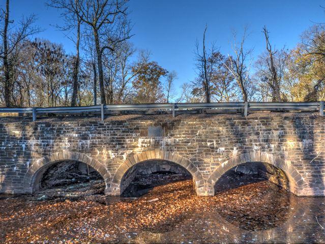
This is a very old stone structure. It was built in 1834 as an aqueduct that carries Six Mile Run under the Delaware and Raritan Canal. At some point the structure was widened by adding a stone arch structure to the east side. The road that parallels the canal passes over this segment. The added stone structure is quite a bit higher in elevation than the original arch. Looking at the barrel of the structure, it is visible further below.
The dimensions given above are what are listed in the National Bridge Inventory. The length of the aqueduct (ie the width of the bridge) is obviously much greater than the roadway width. The roadway width was not listed in the National Bridge Inventory. HistoricBridges.org estimates the overall length of the aqueduct at 135 feet.
Information and Findings From New Jersey's Historic Bridge InventoryDiscussion of Bridge The three-span stone arch was constructed as part of the Delaware and Raritan Canal in 1834. The canal operated until about 1940 and primarily carried Pennsylvania coal to New York. After its closing, the state acquired the canal for a park. In 1984 the aqueduct, which carries the road and the canal/towpath at different levels, was restored. It is one of the largest of at least 16 stone arch structures along the canal. It is listed on the National Register because it carries the canal r-o-w. Discussion of Surrounding Area The bridge is an aqueduct serving to carry both River Road and the neighboring Delaware and Raritan Canal over Six Mile Run. The area is rural with fields and woods. To the north is the 19th-century crossroads village of Blackwells Mills with a restored canal lock tenders house maintained by the Delaware and Raritan Canal State Park. The canal right-of-way is listed in the National Register. Since the structure carries the listed resource, it is interpreted as also being eligible. Bridge Considered Historic By Survey: Yes |
![]()
![]()
![]()
Coordinates (Latitude, Longitude):
Search For Additional Bridge Listings:
Bridgehunter.com: View listed bridges within 0.5 miles (0.8 kilometers) of this bridge.
Bridgehunter.com: View listed bridges within 10 miles (16 kilometers) of this bridge.
Additional Maps:
Google Streetview (If Available)
GeoHack (Additional Links and Coordinates)
Apple Maps (Via DuckDuckGo Search)
Apple Maps (Apple devices only)
Android: Open Location In Your Map or GPS App
Flickr Gallery (Find Nearby Photos)
Wikimedia Commons (Find Nearby Photos)
Directions Via Sygic For Android
Directions Via Sygic For iOS and Android Dolphin Browser
USGS National Map (United States Only)
Historical USGS Topo Maps (United States Only)
Historic Aerials (United States Only)
CalTopo Maps (United States Only)

© Copyright 2003-2025, HistoricBridges.org. All Rights Reserved. Disclaimer: HistoricBridges.org is a volunteer group of private citizens. HistoricBridges.org is NOT a government agency, does not represent or work with any governmental agencies, nor is it in any way associated with any government agency or any non-profit organization. While we strive for accuracy in our factual content, HistoricBridges.org offers no guarantee of accuracy. Information is provided "as is" without warranty of any kind, either expressed or implied. Information could include technical inaccuracies or errors of omission. Opinions and commentary are the opinions of the respective HistoricBridges.org member who made them and do not necessarily represent the views of anyone else, including any outside photographers whose images may appear on the page in which the commentary appears. HistoricBridges.org does not bear any responsibility for any consequences resulting from the use of this or any other HistoricBridges.org information. Owners and users of bridges have the responsibility of correctly following all applicable laws, rules, and regulations, regardless of any HistoricBridges.org information.
![]()